Berlin (DE)
Les Dossiers synthétiques et d'enjeux sont disponibles gratuitement.
Merci de vous inscrire et vous connecter pour accéder au Dossier complet de site.
- Dossier synthétique EN
- Dossier d’enjeux DE | EN
- Le site sur Google Maps
- Retour à la carte
Données synthétiques
BERLIN (DE)
Scales XL/L
Team representative Architect/landscape designer
Location Berlin Pankow, Germany
Population Berlin 3.821.800 inhabitants | Pankow 418.250 inhabitants
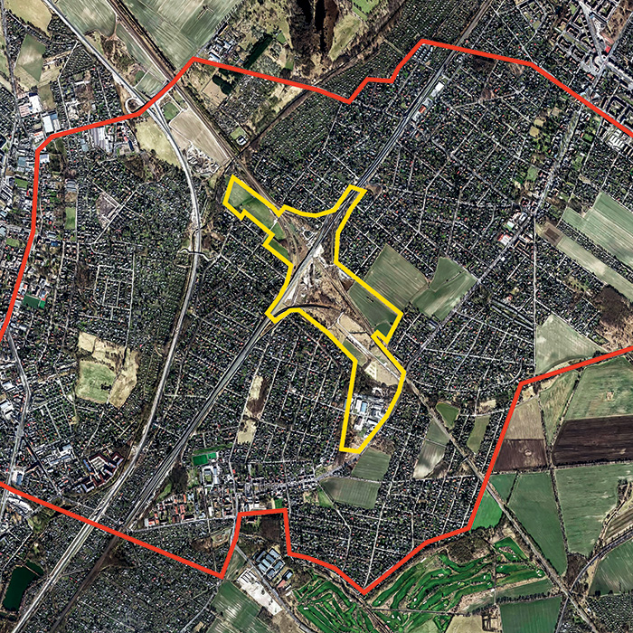
Reflection site 1145 ha - Project site 66 ha
Site proposed by City of Berlin
Actors involved Berlin Senate Administrations, District of Pankow, Deutsche Bahn
Owner(s) of the site Various
Commission after competition In the on-site workshops after the competition, the results are to be discussed on site and adapted if necessary. The next planned step is to commis- sion the winning team(s) with urban planning studies.
Information complémentaire
Inhabited milieu's challenges
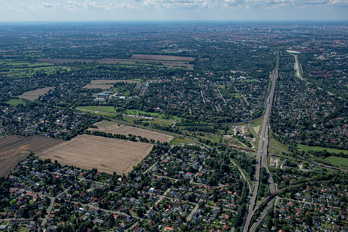
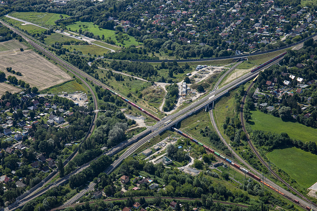
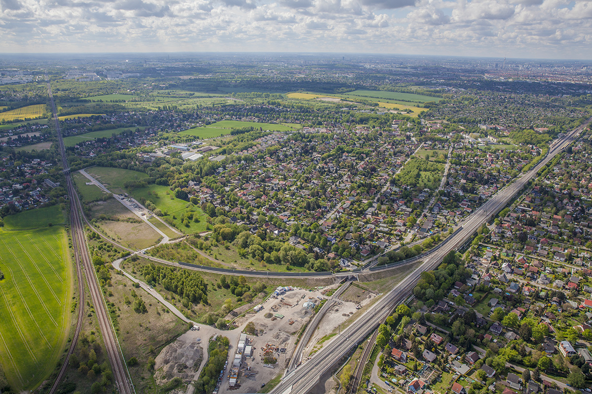
For the Karower Kreuz in the north-east of Berlin, an urban development vision is to be developed that shows how the development of a hybrid traffic junction can become an impulse generator for the further urban development of existing residential quarters.
Berlin’s population has grown continuously by almost half a million inhabitants over the last 20 years. The district of Pankow in the north of Berlin is one of the fastest growing districts and has a particularly dynamic development. In order to meet the challenges associated with this, especially the shortage of housing, Berlin is developing innovative and sustainable urban districts. At Karower Kreuz - where city turns into countryside - there are several large brownfield sites with significant urban development potential for Berlin.
The regional and suburban railway station «Karower Kreuz» can provide impulses for redevelopment within the Europan project site as well as the surrounding area. The aim is to overcome urban development barriers and create a place of networking and interconnection that links the various urban and landscape spaces and enhances them in terms of design.
The interplay of new and existing neighbourhoods at a regional and suburban railway station that is in the preliminary planning stage is the focus of the site. Forward-looking planning approaches are sought at the interface of urban and transport planning. The new station building will make a significant contribution as a nucleus and new urban centre for the further urban development processes in the surrounding area. In terms of urban planning, the designs are to contribute to the debate on urban mobility, density and networking and strengthen an integrated perspective of urban growth.
Questions to competitors
The aim is to create a development concept for the inner area of Karower Kreuz that makes efficient use Blick nach Osten SenStadtWohn Berlin, Fotograf Dirk Laubner, Mai 2019/August 2021 of the space potential, integrates the railway station into the overall concept and gives the public space an atmospheric effect as a place of exchange and encounter.
What degree of urban density is appropriate for the location and what building forms can be used to efficiently fill out the area around the new station so that a recognisable city entrance is formulated that acts as a kick-starter and attractor for the surrounding area?
How can we succeed in establishing a new centrality that does not compete with the existing local town centres and their supply function, but is stimulated by new programmes that are consistently developed from the further thinking of the railway station as a hub of public life and productive interface of ecological, economic, social and cultural values?
Which programme components can be added to new office and commercial buildings so that the public space becomes an urban meeting place and a safe and fear-free urban space is created? How should buildings and especially the ground-floor zones be designed so that they contribute to the revitalisation of the public space?
Questions à propos du site
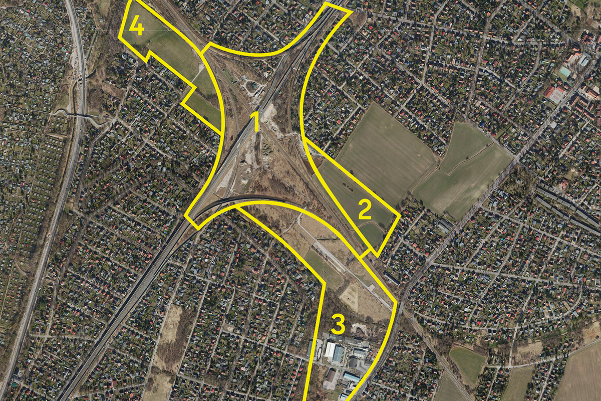
Is the whole area of every plot within the given (yellow) boundaries to be shown on the competition board N2 in 1:2500 scale? Is it allowed to include only (typical) fragments for each of the plots?
Your question was answered by the city of Berlin. You can find the answer in the colloquium report on the Europan website.
Brief mentions some numbers in terms of housing and inhabitants for areas of "Karow Süd", am "Teichberg" and "Strasse 52". Schemes with floor area ratio and floor numbers are provided for the Karower Süd area. Are there any other specific requirements in terms of density/height for other plots?
Your question was answered by the city of Berlin. You can find the answer in the colloquium report on the Europan website.
What are the height limits for the whole area?
Your question was answered by the city of Berlin. You can find the answer in the colloquium report on the Europan website.
Are there any numbers/schemes about the parking space demand in the districts surrounding the project site? (Reflection site)
Your question was answered by the city of Berlin. You can find the answer in the colloquium report on the Europan website.
How many passengers are expected to pass daily through the Karower Kreuz mobility hub? Is there a forecast split by the mobility means? (Sbahn, regional train, bike, bus, car (transferring to train)
Your question was answered by the city of Berlin. You can find the answer in the colloquium report on the Europan website.
Is it allowed to propose any type of (building) construction on the area belonging to the railway?
Your question was answered by the city of Berlin. You can find the answer in the colloquium report on the Europan website.
Is there already a clear vision of how transportation would be organized during the period of the new station construction? Will the Sbahn and regional train be replaced with a shuttle bus in the area affected by the construction site?
Your question was answered by the city of Berlin. You can find the answer in the colloquium report on the Europan website.
What is the timeframe for the construction of the station? Is there any specific date the station needs to be implemented/opened? 2030 was a date found in one of the documents. Is this the foreseen completion date?
Your question was answered by the city of Berlin. You can find the answer in the colloquium report on the Europan website.
Is it allowed to show in detail all four plots on board N3? Or to pick more than one?
Your question was answered by the city of Berlin. You can find the answer in the colloquium report on the Europan website.
Are there any terrain sections available for the area where we could understand the levels of the overlapping railway tracks? Or existing tunnel heights?
Your question was answered by the city of Berlin. You can find the answer in the colloquium report on the Europan website.
Is there a GFA limit for the railway station?
Your question was answered by the city of Berlin. You can find the answer in the colloquium report on the Europan website.
How to deal with projects that are planned/in progress of planning, but not built? Do we include them in the reflection site? (at least for the ones that we know of and information where available online)
Your question was answered by the city of Berlin. You can find the answer in the colloquium report on the Europan website.
What is the use of the folder called "210624 Werningerode Hights " in E17-CSF-DE > E17-CSF-DE-Berlin > 0-New_Docs_after_Launch?
The folder "210624 Werningerode Hights" is obsolete and cannot be removed from the server for technical reasons.
Hello, is it possible to have also the project site as a line in a dwg? Right now in the file called DE_Berlin-PS-M1.1 is only the reflection area recognizable.
You can draw the line on your own by tracing the information from the file DE_Berlin-SS-AP1.2.jpg. The question was forwarded to the city and answered: A sample plan was re-uploaded as a vector file (DE_Berlin-Map_5000.pdf, see complete site brief data update, file "New Documents after Launch") from the complete site brief documents already provided, showing the perimeter line of the project area and the reflection area.
Hi, when will the layout for the boards be uploaded? In the brief it talks about an A1 layout with a square on the upper corner for the number!
You can find the answer in the complete site brief on the Europan website. Please note in particular "9 Submission of Entries" on page 9 and "6.6 Submission requirements" on page 59. There you can find all specific layout requirements. Furthermore, there are no special layout specifications.
See this website at the very top for the site brief PDF.
Here is the website link: https://www.europan-europe.eu/en/session/europan-17/site/berlin-de
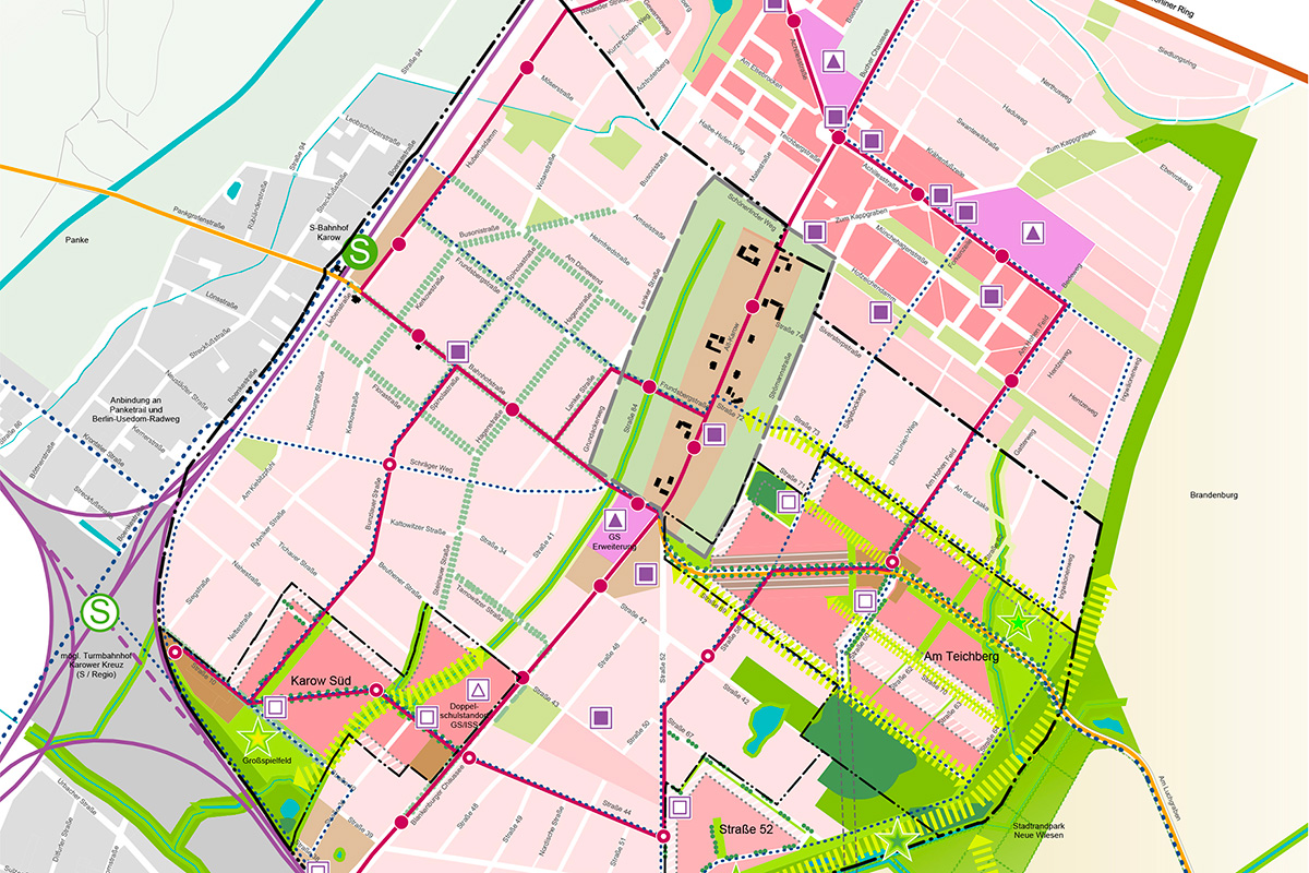
The areas of "Karow Süd", "am Teichberg" and "Straße 52" are all in an early stage and have no urban configuration/planning. But these areas are included in the "Reflection Site". Do we draw a future, hypotetical scenario in which the masterplans for these are fully developed?
The question was forwarded to the city and answered: A density study was uploaded as a new PDF-file (DE_Berlin-T6.pdf, see complete site brief data update, file "New Documents after Launch") providing test designs to guide density in the designated subareas. Please note in particular, these test designs can either be adopted by the participants or adapted to their own design, whereby all three sub-areas should definitely be considered as building land and not as agricultural land. Due to the spatial proximity to the "Karower Kreuz" intersection, it is recommended that the sub-area "Karow Süd", north of "Straße 10", be examined in more detail with regard to traffic connections, building forms, etc.
Considered that we don't have enough background information for the areas "Teichenberg, Straße 52, Karow Süd" could we instead represent today's situation where these areas are still empty plots? how careful should be our plan for these areas?
The question was forwarded to the city and answered: A density study was uploaded as a new PDF-file (DE_Berlin-T6.pdf, see complete site brief data update, file "New Documents after Launch") providing test designs to guide density in the designated subareas. Please note in particular, these test designs can either be adopted by the participants or adapted to their own design, whereby all three sub-areas should definitely be considered as building land and not as agricultural land. Due to the spatial proximity to the "Karower Kreuz" intersection, it is recommended that the sub-area "Karow Süd", north of "Straße 10", be examined in more detail with regard to traffic connections, building forms, etc.
Le site est lié au thème suivant
PENSEZ TABULA NON-RASA! À travers le monde, certaines réserves naturelles sont des déserts - chauds ou froids ; elles abritent cependant toutes sortes d'animaux et de micro-organismes cachés dans les fissures, dans les crevasses et sous les rochers. Certains sites semblent vides, inoccupés ; ils ne le sont pourtant pas. Ils sont pleins de vie, cachée dans le sol ou dans l'air. Ils font partie d'un équilibre plus large de forces et de processus naturels. Sur ces sites, un grand nombre de nouveaux programmes est nécessaire. Il faut voir ces sites comme une chance de multiplier les formes de vie. Voir la demande de construction de nouveaux habitats comme une chance de concevoir un environnement global. Il faut penser tabula non-rasa !
Concevoir de nouveaux habitats comme milieu global
Documents spécifiques
Questions à propos du site
Pour pouvoir poser une question, vous devez être connecté (et, par conséquent, inscrit au concours).
Ve. 2 Juin 2023
Date limite de soumission des questions
Ve. 16 juin 2023
Date limite de réponses aux questions
Avant de soumettre votre question, assurez-vous qu'elle n'apparaît pas déjà dans la FAQ.
Merci de poser vos questions sur les sites dans le menu Sites.
Merci de poser vos questions sur le règlement dans le menu Règlement.
Si votre question ne reçoit pas de réponse dans les 10 jours, merci de vérifier qu'elle ne figure pas dans la FAQ sous un autre intitulé ; sinon, contactez le secrétariat concerné par email (secrétariats nationaux pour les sites, secrétariat européen pour le règlement.)