München (DE)
Les Dossiers synthétiques et d'enjeux sont disponibles gratuitement.
Merci de vous inscrire et vous connecter pour accéder au Dossier complet de site.
- Dossier synthétique EN
- Dossier d’enjeux DE | EN
- Le site sur Google Maps
- Retour à la carte
Données synthétiques
MÜNCHEN (DE)
Scales L/S
Team representative Architect, urbanist and landscape architect
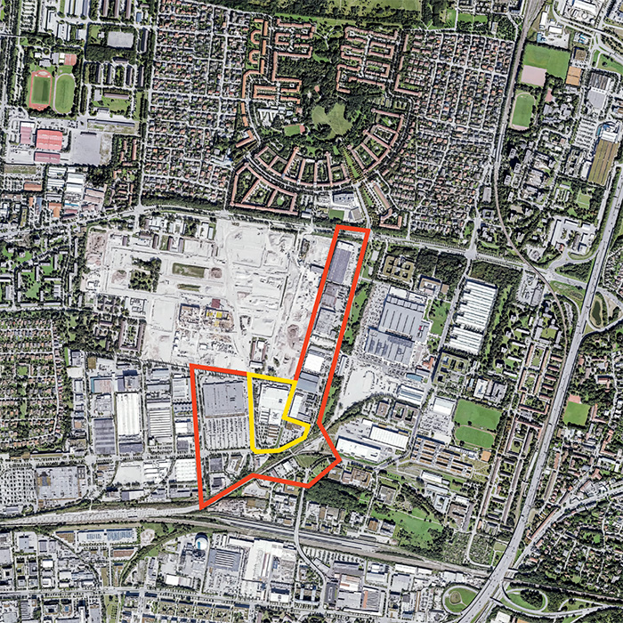
Location Munich, Europark
Population 1 579 000 inhabitants
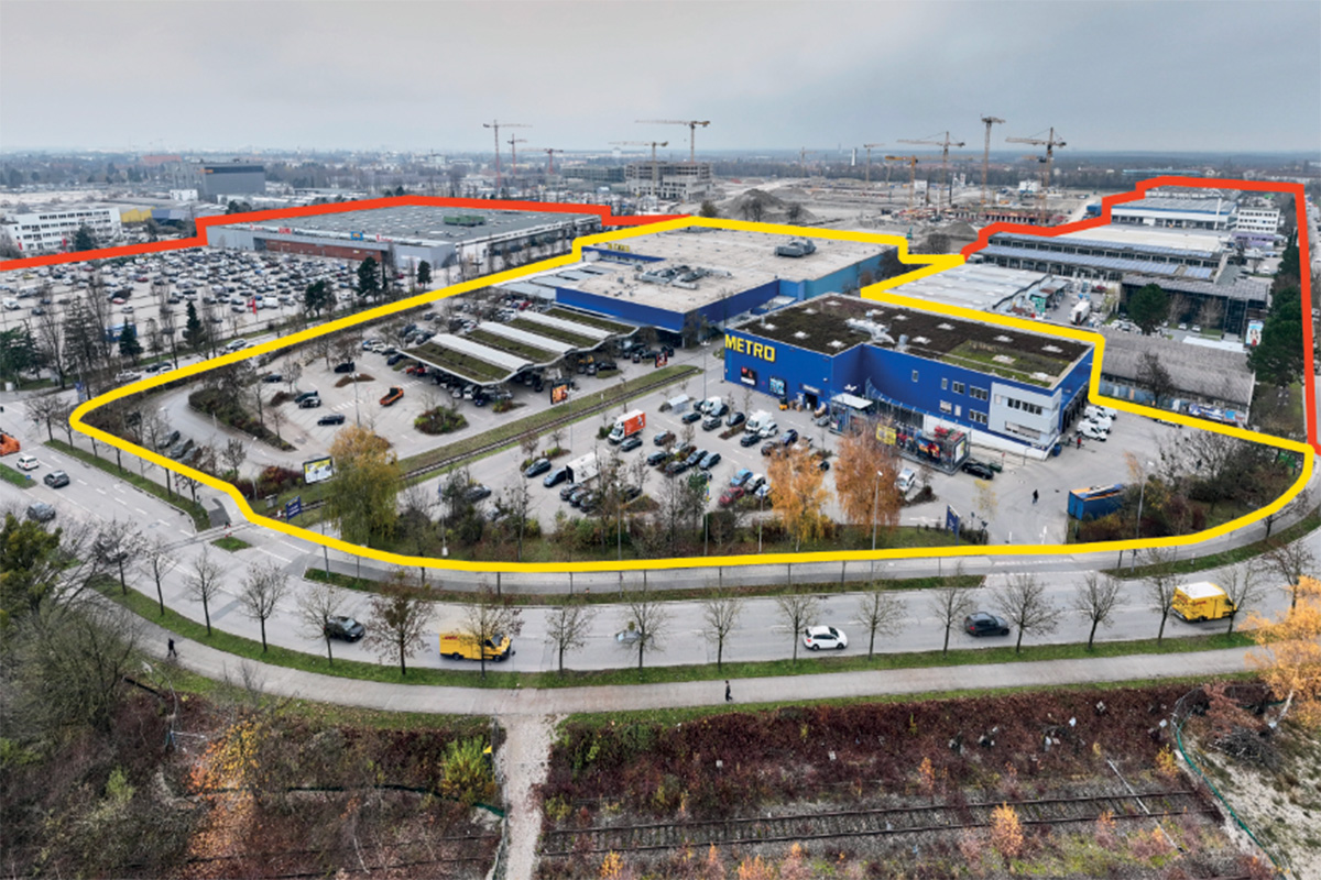
Reflection site 25,7 ha - Project site 4,2 ha
Site proposed by City of Munich
Actors involved Referat für Stadtplanung und Bauordnung, Stadt München; HWB 39 GmbH & Co. KG
Owner(s) of the site 18 owners of the study site, one owner of the project site
Commission after competition The planned steps after the competition include the transition of the results into urban land use planning as well as the constructional implementation for the project site. However, this requires the approval of the local politicians and the city council. Subsequently, the planning can be advanced in cooperation with the owner or developer and the team selected in the competition.
Information complémentaire
Inhabited milieu's challenges
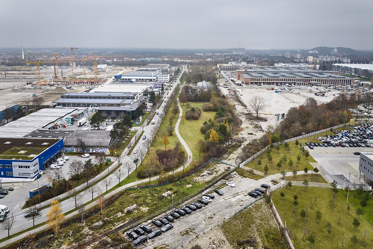
The metropolis of Munich, Germany’s third-largest city, wants to be climate-neutral by 2035. A major challenge is to cope with the pressure of growth on the one hand and climate change on the other. Munich is trying to meet this by increasing the density of its inner city. One of the largest urban development areas in Europe is located in the north of Munich and in the immediate vicinity of the Europan site. The former Bavarian barracks are being transformed into a mixed-use quarter for about 15,000 inhabitants called «Neufreimann».
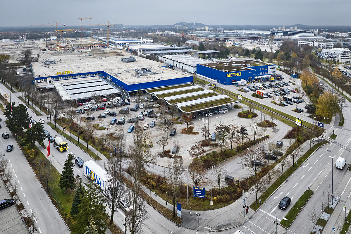
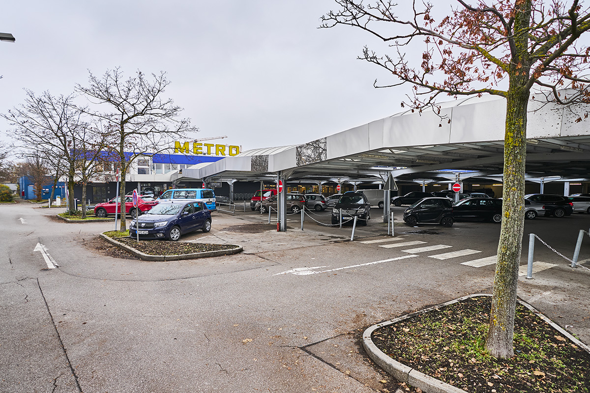
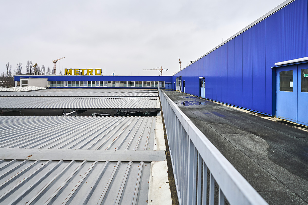
The competition area is located in the Europark commercial area and is to be sensibly integrated into the urban development context between the future Neufreimann quarter, the commercial areas with cultural uses to the east and the purely commercial uses adjoining it to the west and south. The Europan task is to develop forward-looking ideas for the redensification or redevelopment of the existing commercial area into a mixed, urban, productive and lively urban site.
As a «resilient hybrid urbanism», the site is to serve as a pilot for considerations on hybrid spaces. The aim is to achieve a mix of uses for different types of housing and commercial typologies: we are looking for innovative solutions for the coexistence or superimposition of commercial and residential uses.
The commercial and specialist market location is to be further developed in a space-efficient manner and additional mixed uses such as offices and housing are to be created. The aim is to achieve a high urban density with a simultaneous high quality of greening.
In conjunction with the urban planning idea, a concise open space system with public, communal and private green spaces and pathways with a high quality of stay is to be created. The overall goal is to develop a sustainable, climate-neutral and climate-sensitive neighbourhood.
Questions to the competitors
What does it mean to redensify an existing commercial area in the city centre of a metropolis in a future-oriented way? How does it become a mixed, liveable, lively, urban and productive urban development?
What building typologies are needed? Are there high-rise buildings? What does the ground floor zone look like? What will happen on the roofs? Who will live here? Who can work here? What cultural and social uses will there be? Will office, administration, service, production, processing and crafts come together with residential use? Can the existing buildings be preserved in terms of sustainability and integrated into the overall concept? How can the combination of residential and commercial be rethought? On top of each other? Next to each other? One inside the other? One after the other? With each other? What could be flexible uses?
What could a hybrid, resilient urban development look like in the existing context? The goal is a climate-neutral and resilient neighbourhood with different uses and an attractive green and open space system. What do concise public open spaces with a high quality of stay look like? How private and how communal (green) spaces?
Where does climate protection and adaptation take place? What is needed in terms of construction so that synergies can be created between ecological, social, economic and cultural aspects? What will happen in the long term in the area under consideration? What is specifically proposed for the project site? In which development phases could the realisation take place? How can pedestrian and bicycle traffic be strengthened? How does the neighbourhood link up with its surroundings? How will I get to the Isar and the English Garden in the future?
Questions à propos du site
Can the Organiser provide floor plans and/or sections of the existing building (Metro)?
Response from the city: We are not seeking to preserve this building. The provision of a plan is therefore not useful from our point of view.
Hallo together, Part of the Competition for Munich is the Document "Beschluss_Bahnuebergang_Anlage 3..." for the Planing of the Railpass Lindberghstrasse. Could we have this Document as a vectorised File?
Unfortunately, we cannot provide a vector file for the level crossing. Please use the attached documents or the links to help yourself.
Würden Sie bitte den verkehrlichen Plan von Neu Freimann anbieten?
Currently, it is being checked whether further documents on Neufreimann can be made available.
Sind Verkehrszählungen für die Maria-Probst-Straße vorhanden? (Anzahl Lkw- und Pkw-Verkehr)
Exact figures are not known here.
DE: Genaue Zahlen sind hier nicht bekannt.
Sind die Straßen im Neufreimann-Viertel als Shared Space oder Zone 30 geplant?
The ring road Neufreimanns is planned as a zone 30.
DE: Die Ringstraße Neufreimanns ist als Zone 30 geplant.
Auf der Maria-Probst-Str. 47 befindet sich das Gebäude des Kulturreferats. Hier werden sowohl Veranstaltungstechnik verliehen, als auch Seminare gehalten. Außerdem wird auf der Webseite des Kulturreferats Ausbildungsplätze angeboten. Findet die Ausbildung ebenso im Gebäude statt. Falls ja, mit wie vielen Auszubildenden ist pro Jahrgang zu rechnen?
Exact figures are not known here. Assumptions have to be made for corresponding flexible playable uses.
DE: Genaue Zahlen sind hier nicht bekannt. Es sind Annahmen zu treffen für entsprechend flexibel bespielbarer Nutzungen.
Wird es entlang der neuen Tramlinie über den DB-Nordring nur Fuß- und Radwege geben oder werden Fahrspuren für den motorisierten Verkehr mitgeplant? Falls der motorisierte Verkehr entlang der Tramlinie geführt wird, soll diese neue Straße eine Entlastung der Maria-Probst-Str. darstellen?
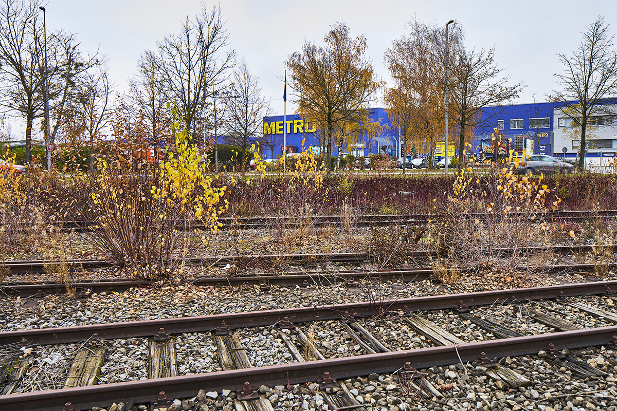
Due to the railroad track to the south, the competition area cannot be accessed by private vehicles from the south, from the main road Frankfurter Ring between the tangents.
from the south, from the main road Frankfurter Ring between the tangents.
The planned construction of a connecting road with a railroad crossing between Maria-Probst-Strasse and Lilienthalallee is intended to improve access to the Europark from the Frankfurter Ring. A new road connection of approx. 100 m length and the construction of a new level crossing are planned. (see Figure 10/ 13) and information on the resolution
Level crossing Lindberghstraße via Council Information System: https://risi.muenchen.de/risi/sitzungsvorlage/detail/5609754?dokument=v5682464
With the bridge for the extension of the streetcar line over the DB-Nordring, pedestrian and bicycle paths are to be created.
DE:
Aufgrund der südlich liegenden Gleistrasse ist eine MIV-Erschließung des Wettbewerbsgebietes
von Süden, von der Hauptverkehrsstraße Frankfurter Ring zwischen den Tangenten, nicht gegeben.
Der geplante Bau einer Verbindungsstraße mit Bahnübergang zwischen Maria-Probst-Straße und Lilienthalallee soll die Erschließung des Europarks vom Frankfurter Ring verbessern. Geplant ist eine ca. 100 m lange neue Straßenverbindung und der Neubau eines höhengleichen Bahnübergangs. (s. Abbildung 10/ 13) und Information zum Beschluss
Bahnübergang Lindberghstraße über Ratsinformationssystem: https://risi.muenchen.de/risi/sitzungsvorlage/detail/5609754?dokument=v5682464
Mit der Brücke für die Verlängerung der Tramlinie über den DB-Nordring sollen Fuß- und Radwege entstehen.
I have a question about the Munich Site: Would you recommend to respect the limits of the property boundaries in the design or are you considering a reallocation procedure ("Umlegungsverfahren") together with the development plan?
The goal is a sensible and forward-looking redensification or redevelopment of the existing commercial area into a mixed, urban, productive and lively urban building block. The aim is to achieve a mix of uses for different types of housing and commercial
different commercial typologies in a compatible ratio.
Innovative ideas for an urban building block with the above-mentioned objectives are to be developed through sensible redensification or reorganization of the structures.
If the design idea requires it, it is also possible to think beyond the property boundaries.
In the area of the project area, the parcel boundaries can be neglected, since this is to be developed coherently by one owner.
DE:
Ziel ist eine sinnvolle und zukunftsweisende Nachverdichtung bzw. Neuentwicklung des bestehenden Gewerbegebietes zu einem gemischten, urbanen, produktiven und lebendigen Stadtbaustein. Dabei soll eine Nutzungsmischung verschiedener Wohnformen und
unterschiedlicher Gewerbetypologien in einem verträglichen Verhältnis abgebildet werden.
Durch eine sinnvolle Nachverdichtung bzw. Neuordnung der Strukturen sollen innovative Ideen für einen Stadtbaustein mit o.g. Zielsetzungen entwickelt werden.
Wenn es die Entwurfsidee erfordert, kann auch über die Grundstücksgrenzen hinausgedacht werden.
Im Bereich des Projektgebietes können die Flurstücksgrenzen vernachlässigt werden, da dieses von einem Eigentümer zusammenhängend entwickelt werden soll.
A question for Munich: What does it mean, to integrate 3.000 m² floor space for a public structure within the larger perimeter? What public structure is it exactly and what GFA is needed for it in total?
Passus from the english „Brief“
For public infrastructure (e.g. a school location), a location that with at least 3,000 m² of floor space can be used more flexibly should be provided in the study site.)
Answer:
The use of the public infrastructure in the area under consideration with a minimum floor area of 3,000 m2 has not yet been conclusively determined. For example, it could mean a possible expansion area for the existing school site, which has not yet been defined in more detail. This area could also be used for other social infrastructure facilities. In order to still allow leeway and utilization concepts in the use here, a more flexibly usable location with at least 3,000 m² of floor space is to be provided in the area under consideration.
DE:
Die Nutzung der öffentlichen Infrastruktur im Betrachtungsraum mit min. 3.000 m2 Grundfläche steht noch nicht abschließend fest. Es könnte beispielsweise eine mögliche Erweiterungsfläche für den bestehenden Schulstandort gemeint, der bisher nicht näher definiert ist. Auch könnte diese Fläche für andere soziale Infrastruktureinrichtungen genutzt werden. Um hier in der Nutzung noch Spielräume und Nutzungskonzepte zu ermöglichen, ist ein flexibel nutzbarerer Standort mit mindestens 3.000 m² Grundfläche im Betrachtungsraum vorzusehen.
Are there any future considerations/ plans of the reactivation of the train tracks of DB-Nordring for transporting goods?
We frowarded your qestion and will get back to you as soon as we get the answer.
Should the "Rahmenplanung Frankfurter Ring" be considered as part of the existing built environment?
We frowarded your qestion and will get back to you as soon as we get the answer.
Le site est lié au thème suivant
IMAGINEZ UNE SECONDE VIE ! Une seconde vie ! est la métamorphose d'une situation. L'enjeu est de régénérer et d'accompagner les espaces à transformer à partir d'un nouveau regard sur le préexistant et sur les trésors cachés déjà sur place. Une nouvelle revalorisation de toutes les ressources : naturelles, patrimoniales, énergétiques, de flux, économiques, sociales… Il s'agit de reconsidérer les usages et les nouvelles proximités liant les dynamiques écologiques et sociales. Comment être attentif et accueillant aux différences et aux vulnérabilités dont se nourrissent les milieux habités face au changement climatique ?
Transformer les quartiers et les bâtiments en milieux inclusifs
Documents spécifiques
Questions à propos du site
Pour pouvoir poser une question, vous devez être connecté (et, par conséquent, inscrit au concours).
Ve. 16 mai 2025
Date limite de soumission des questions
Ve. 30 mai 2025
Date limite de réponses aux questions
Avant de soumettre votre question, assurez-vous qu'elle n'apparaît pas déjà dans la FAQ.
Merci de poser vos questions sur les sites dans le menu Sites.
Merci de poser vos questions sur le règlement dans le menu Règlement.
Si votre question ne reçoit pas de réponse dans les 10 jours, merci de vérifier qu'elle ne figure pas dans la FAQ sous un autre intitulé ; sinon, contactez le secrétariat concerné par email (secrétariats nationaux pour les sites, secrétariat européen pour le règlement.)