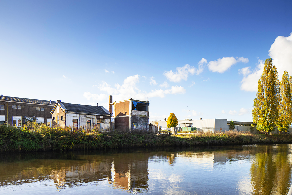
Amersfoort-Kop van Isselt (NL)
Les Dossiers synthétiques et d'enjeux sont disponibles gratuitement.
Merci de vous inscrire et vous connecter pour accéder au Dossier complet de site.
- Dossier synthétique EN
- Dossier d’enjeux EN
- Le site sur Google Maps
- Retour à la carte
Données synthétiques
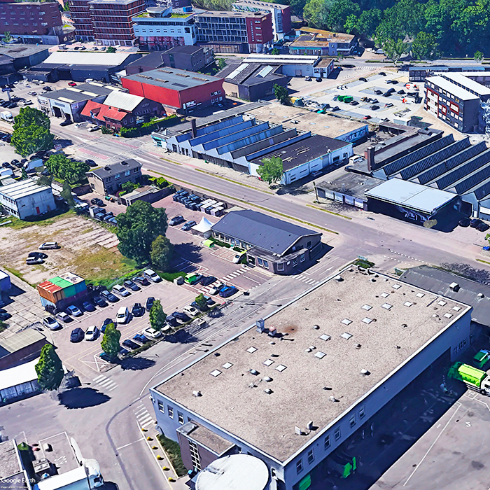
Amersfoort-Kop van Isselt (NL)
Échelle L/S
Composition d’équipe Architecte non obligatoire
Localisation Kop van Isselt, Amers- foort
Population 160,000 habitants / 285,000 habitants Metro
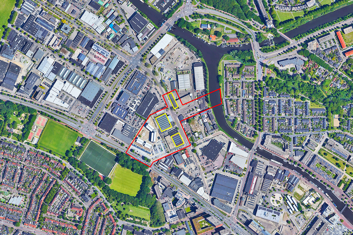
Site de réflexion 3,45 ha - Site de projet 0,32 ha
Site proposé par Municipalité d'Amersfoort
Acteurs impliqués Municipalité d'Amersfoort
Propriétaire(s) du site Municipalité d'Amersfoort
Phase post-concours La municipalité d'Amersfoort, en partenariat avec le(s) propriétaire(s) des bâtiments du patrimoine industriel, s'est engagée à réaliser l'espace public central. Actuellement, le(s) bâtiment(s) sont destinés à un usage temporaire, le(s) propriétaire(s) souhaite(nt) faire évoluer les concepts et les typologies développés dans le cadre du concours vers un projet viable et rentable, dans le but de le réaliser. La municipalité envisage également la possibilité de commander d'autres études de conception pour l'espace public central, afin d'explorer les possibilités d'un développement urbain réfléchi.
Information complémentaire
SITE / CONTEXTE
Amersfoort réinvente son paysage urbain pour créer une croissance dynamique, durable et inclusive. La transformation de la zone de Kop van Isselt offre l'occasion de réintégrer l'héritage industriel dans un quartier dynamique. Ce développement à usage mixte envisage 2 000 à 3 000 nouvelles résidences, des industries créatives et des équipements publics, favorisant un écosystème urbain vivant et durable. Proposez des solutions audacieuses mais pratiques pour la transformation complète de cette zone en réaffectant les structures du patrimoine industriel, en intégrant divers programmes à usage mixte et en améliorant la connectivité écologique. L'objectif est de créer une zone urbaine centrale distinctive avec une identité renouvelée, en créant des espaces publics dynamiques qui reflètent l'adaptabilité et la durabilité tout en répondant aux besoins locaux et à l'échelle urbaine.
QUESTIONS AUX CONCURRENTS
Réutilisation adaptative du patrimoine industriel
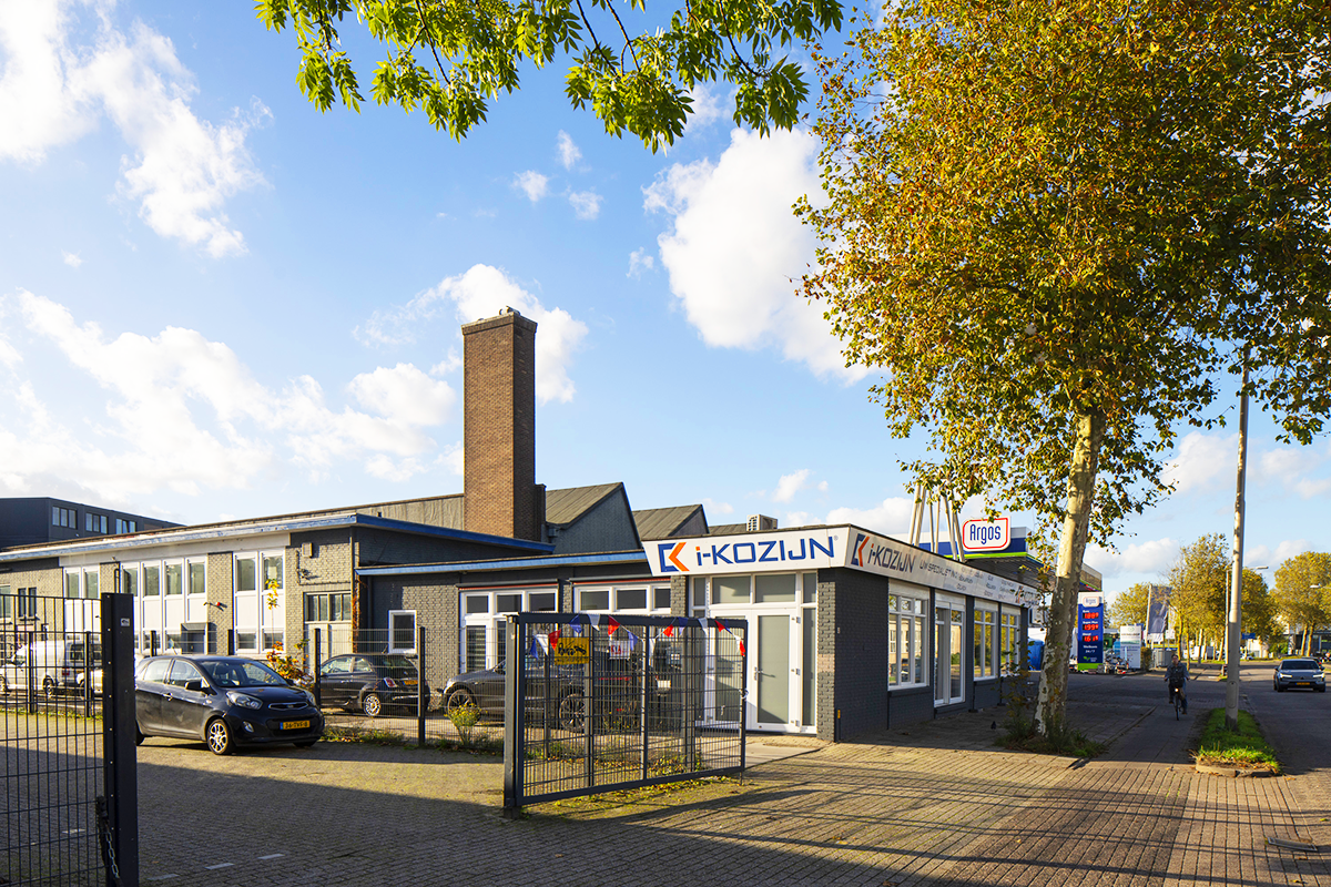
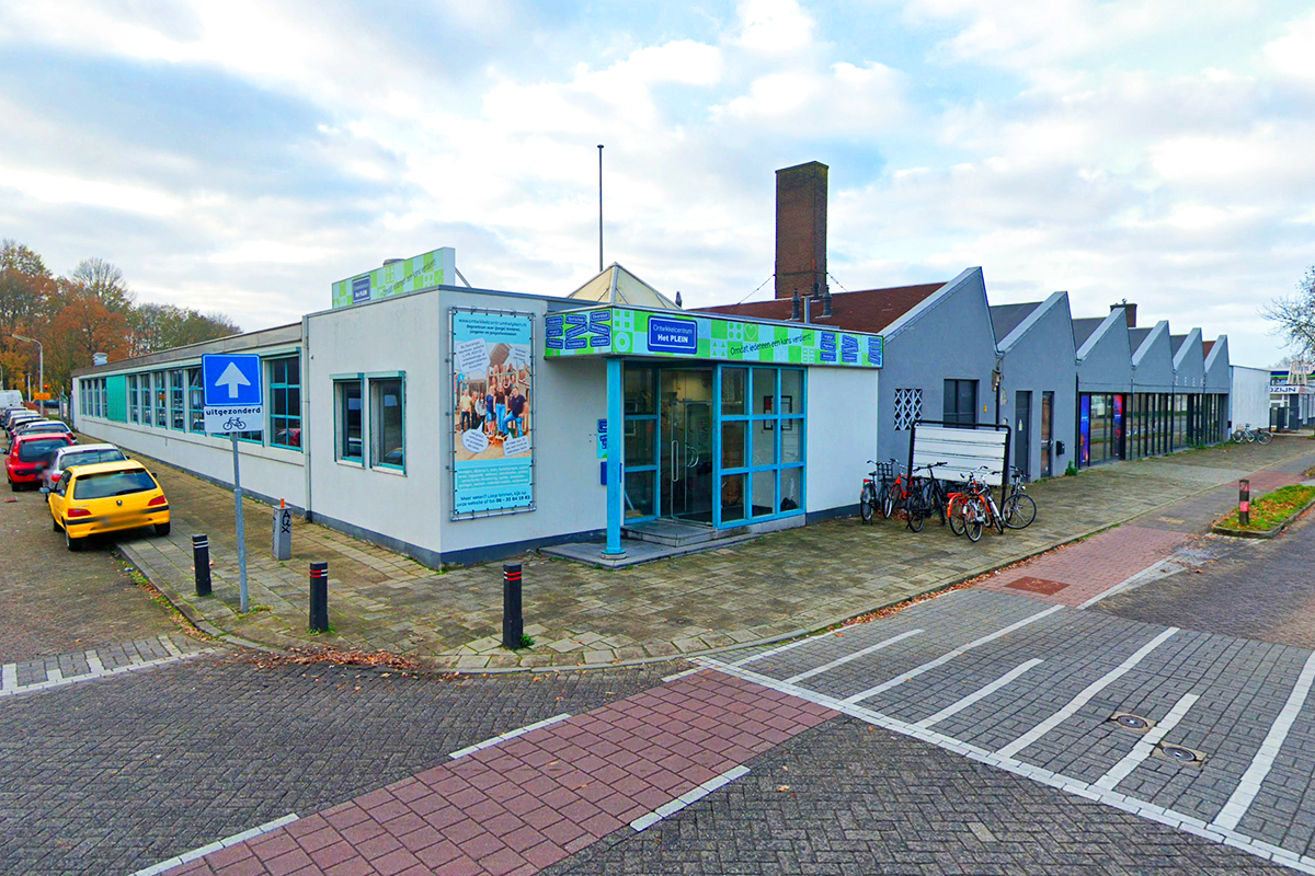
Les bâtiments industriels historiques au cœur de Kop van Isselt sont destinés à une réutilisation adaptative, devenant des pôles dynamiques pour les industries créatives, les fonctions publiques et les activités récréatives. Ces structures ancreront le quartier, alliant leur patrimoine architectural à des conceptions modernes et fonctionnelles pour façonner l'identité de l'espace public central. Une stratégie globale d'enveloppe de bâtiment devrait explorer comment ces bâtiments peuvent être transformés pour libérer leur plein potentiel. Cela peut inclure des extensions latérales, des ajouts verticaux ou des interventions architecturales innovantes qui préservent leur importance historique. Ces stratégies doivent démontrer leur viabilité financière en harmonisant une conception innovante avec des solutions pragmatiques qui garantissent un succès à long terme.
Eempark comme cœur vert
Eempark est conçu pour être au cœur du quartier, reliant les quartiers par des espaces de loisirs pour les sports, les pique-niques et des sentiers pour le vélo et la marche. Il renforcera la biodiversité en reliant la ceinture verte (Groengordel) du Soesterkwartier à l'Eem, formant un corridor écologique qui stimule la biodiversité et la connectivité. Proposer une conception conceptuelle visionnaire pour l'espace public central qui intègre le dynamisme urbain à l'infrastructure verte. Incorporer un paysage en terrasses pour une atténuation efficace des inondations et mettre en évidence une meilleure accessibilité à la rivière Eem pour favoriser les opportunités récréatives et écologiques. Les pistes cyclables et piétonnes doivent assurer des connexions transparentes aux bâtiments centraux.
De nouvelles façons de vivre intéressantes
Transformer les bâtiments existants à un seul étage (tous les bâtiments dans la zone de réflexion) pour accueillir environ 160 unités d'habitation, contribuant à 16 500 m2 de surface habitable (hors parking). Landmark NeNaFa et fabriek van Van der Meiden peuvent s'élever jusqu'à 14-16 étages, mais le hangar ROVA est classé monument municipal, l'intérieur est également protégé. Le changement doit être fait en conjonction avec les valeurs monumentales. De nouveaux volumes de construction peuvent être ajoutés au-dessus, à côté ou à travers les halls existants, tout en préservant et en célébrant leur caractère industriel. Cette intégration des espaces résidentiels devrait favoriser une atmosphère communautaire animée en introduisant de nouvelles façons de vivre intéressantes à travers des typologies innovantes qui redéfinissent les modes de vie urbains.
Incubateur créatif et communauté
Pour répondre à la demande croissante d'espaces créatifs et axés sur la santé, les enveloppes de bâtiment proposées (tous les bâtiments dans la zone de réflexion) comprendront un incubateur créatif de ± 2 500 m2 qui offrira des espaces de création indispensables, favorisant l'innovation et la collaboration. De plus, le centre de santé de ±1 000 m2 abritera une pharmacie (160 m2), un cabinet de médecine générale (410 m2), une physiothérapie (100 m2), un dentiste (250 m2) et un cabinet de sages-femmes (40 m2). Le nouveau bâtiment doit incarner la conception circulaire, les énergies renouvelables et la biodiversité en son cœur.
Questions à propos du site
The building block incl.NeNaFa hall varies across documents. The axo in the site brief shows a free-standing tower(p.47), while the plan drawing(p.38) shows a hall as part of an urban block. The heritage analysis suggests a high-rise and block behind the hall. Is the block envelope predefined or is its design part of the competition task?
1. We are aware that the representation of the building block, including the NeNaFa hall, varies across different documents. For clarification, page 47 of the brief provides the most relevant summary of the intended spatial framework.
2. The volumes illustrated on page 47 are indicative only—they represent the maximum allowed volume, not a fixed design. You are free to interpret and position the new volumes creatively: they can sit on top of, next to, or intersectingthe existing hall. The form is also flexible—they do not need to follow the square geometry shown in the axonometric diagram.
3. The shape and layout of the park should follow the red boundary line as defined in the brief, but its internal configuration and design of the park is part of the competition scope.
Is it possible to provide technical drawings / surveys of the buildings on Project Site? There are very little documentation provided and 2d drawings in site's folder pdf's (NeNaFa waardestelling for instance) are too low resolution to read dimensions and use effectively for modelling.
Fortunately we found plans for theNijverheidsweg_Noord_35 as pdf , but not available in a digital (CAD) format. please do downloaed it from the folder named "0-New_Docs_after_Launch"
The Protected Warehouse in Nijverheidsweg-Noord, 35 is different on every document received and none of them is matching the measures that we could extract from Google Maps. Being a Protected monument, is it possible to have some clearer drawing in order to better conceived a future use? Thanks in advance
1. We are aware that the representation of the building block, including the NeNaFa hall, varies across different documents. For clarification, page 47 of the brief provides the most relevant summary of the intended spatial framework.
2. The volumes illustrated on page 47 are indicative only—they represent the maximum allowed volume, not a fixed design. You are free to interpret and position the new volumes creatively: they can sit on top of, next to, or intersectingthe existing hall. The form is also flexible—they do not need to follow the square geometry shown in the axonometric diagram.
3. The shape and layout of the park should follow the red boundary line as defined in the brief, but its internal configuration and design of the park is part of the competition scope.
Reding the many useful documents of the "PS-f reading list", there are many different Masterplan that regulate the area surrounding the study area of our project site. In order to better design our proposal considering an already existing Masterplan, which one should we consider as the final? Thanks in advance
1. We are aware that the representation of the building block, including the NeNaFa hall, varies across different documents. For clarification, page 47 of the brief provides the most relevant summary of the intended spatial framework.
2. The volumes illustrated on page 47 are indicative only—they represent the maximum allowed volume, not a fixed design. You are free to interpret and position the new volumes creatively: they can sit on top of, next to, or intersectingthe existing hall. The form is also flexible—they do not need to follow the square geometry shown in the axonometric diagram.
3. The shape and layout of the park should follow the red boundary line as defined in the brief, but its internal configuration and design of the park is part of the competition scope.
Hello, I would ask if it's possible to receive a more detailed 3D Model of the buildings and the context of Amersfoort-Kop van Isselt, with also the level curves of the surrounding landscape. Thanks in advance. Arch. Marco Casalena
Unfortunately, we do not have plans in more 3D detail as per your request
Are there any other uses for the surrounding development area besides work, housing and parking, such as a school, kindergarten or public buildings? And if so, where should they be located? Thanks in advance.
All the known information regarding Kop van Isselt plan (beyound the red boundery) is shared in the complite site folder. (E18-CSF-NL-Amersfoort-Kop_van_Isselt/3-Project_Site/PS-f_reading-list')
Regarding the Project Area (yellow areas). Is it mandatory for new buildings to be inside the areas with the yellow outline, or can we think of putting them in other locations as well (e.g., adjacent to historic industrial buildings)?
1. yellow area is to show what volumen must stay, you are allowed to position the new volumes creatively: they can sit on top of, next to, or intersecting the existing hall.
2. The volumes illustrated on page 47 are indicative only—they represent the maximum allowed volume, not a fixed design. You are free to interpret and position the new volumes creatively: they can sit on top of, next to, or intersecting the existing hall. The form is also flexible—they do not need to follow the square geometry shown in the axonometric diagram.
Shall we provide covered/uncovered parking areas (for cars) in the plot?
1. 15 parking spaces for creative incubator/ Health centre, plus 0.4 spaces per dwelling.
2. The 15 spaces required for the creative incubator/ Health centre can be accommodated underground in the new block behind the NeNaFa building. (page 47)
3. The 0.4 spaces per dwelling will be provided within the communal parking structures in the larger masterplan area, so there’s no need to account for them separately.
4. Parking in the red-marked area is not permitted.
For the historical buildings (NeNaFa and Van Der Meiden) located in the plot, are there any indications regarding which part should be kept? Can we demolish the recent additions, while keeping only the shed parts?
1. The characteristic historical building parts, particularly those with triangular roofs, should be preserved, while the newer and modern additions may be demolished.
2. Yes, you demolish the recent additions, while keeping only the shed parts.
The DWG files provided are showing the current condition of the area. Are we supposed to use these ones as base for our drawings or the scenario of the new development of the area (as shown in the latest 3D shared in the new docs after launch)?
1. as shown in the latest 3D shared in the new docs after launch is one of the scenario of the new development of the area. the 3D can be used to understand what kind of volumes can be expected in the sarroundings of our site. the 3d provided is not final as of now!
2. We are aware that the representation of the building block, including the NeNaFa hall, varies across different documents. For clarification, page 47 of the brief provides the most relevant summary of the intended spatial framework.
What is the program to be located in the ROVA building?
ROVA building is classified as a municipal monument, the interior is also protected. The change must be done in conjunction with the monumental values. you are free to propose any function(s) as far as is public/open to all.
Is the bridge connecting the two banks of the Eem part of our design scope?
yes
Is the bridge supposed to be fix or movable (in order to let boats pass)?
Please do consider all aspects passing boats, heights of the two sides etc. we are open to any ideas either fix or movable!
For representation purpose, do we need to use the current state plan shared in DWG? or the new masterplan shared in 3D?
1. for sarrounding to our location you can us the 3d provided.
2. We are aware that the representation of the building block, including the NeNaFa hall, varies across different documents. For clarification, page 47 of the brief provides the most relevant summary of the intended spatial framework.
3. The volumes illustrated on page 47 are indicative only—they represent the maximum allowed volume, not a fixed design. You are free to interpret and position the new volumes creatively: they can sit on top of, next to, or intersectingthe existing hall. The form is also flexible—they do not need to follow the square geometry shown in the axonometric diagram.
4. The shape and layout of the park should follow the red boundary line as defined in the brief, but its internal configuration and design of the park is part of the competition scope.
In the 3D model received from the documents "after the Launch" there are two building near the Amsterdamseweg that are inside of the red boundary line. Are we free to decide what happens to them? (redesign, delete, etc)
1. We are aware that the representation of the building block, including the NeNaFa hall, varies across different documents. For clarification, page 47 of the brief provides the most relevant summary of the intended spatial framework.
2. The volumes illustrated on page 47 are indicative only—they represent the maximum allowed volume, not a fixed design. You are free to interpret and position the new volumes creatively: they can sit on top of, next to, or intersectingthe existing hall. The form is also flexible—they do not need to follow the square geometry shown in the axonometric diagram.
3. The shape and layout of the park should follow the red boundary line as defined in the brief, but its internal configuration and design of the park is part of the competition scope.
For confirmation only. Do you confirm that the 3D file to be used as main context for our proposal is the one named "les", uploaded on April 20th? In that case, some of the new buildings are occupying part of the park included in the red line.
yes
Regarding the new block, is it possible to move it everywhere inside the plot (ie next to the river) or its location is fixed?
1. As shown on pages 47 and 55, the two should be understood as complementary and representing the same idea. Page 47 indicates that three volumes (blue) are to be added, and the new block should be proposed approximately in the location shown on that page.
2. Total of ±160 housing units spread over (NeNaFa, Van der Meiden and New block) contributing 16,500m2 GFA of residential space (excluding parking) A creative incubator ±2,500 m2 spread over (NeNaFa, Van der Meiden and New block) Health centre ±1,000 m2 spread over (NeNaFa, Van der Meiden and New block)
Page 38 of the brief outlines the proposed phasing plan. Is there a diagram showing the area in relation to the phases? Or do the four phases refer to the image below on the same page? If not, could the organiser indicate which document or page clarifies this? Street names are unclear.
You can find more information in the document 472_sh_OntwikkelkaderKVI, specifically on pages 92 to 95.
P. 47 shows three new volumes for approximately 160 units. However, the competition assignment on p. 55 and the project site boundaries do not include the location of the new block shown on p. 47. Is it therefore possible to add a separate volume outside the project site boundaries (yellow lines) in order to meet the programme requirements?
1. As shown on pages 47 and 55, the two should be understood as complementary and representing the same idea. Page 47 indicates that three volumes (blue) are to be added, and the new block should be proposed approximately in the location shown on that page.
2. Total of ±160 housing units spread over (NeNaFa, Van der Meiden and New block) contributing 16,500m2 GFA of residential space (excluding parking) A creative incubator ±2,500 m2 spread over (NeNaFa, Van der Meiden and New block) Health centre ±1,000 m2 spread over (NeNaFa, Van der Meiden and New block)
We kindly ask you to provide a clear and definitive answer to the following question, which we have previously raised: Will the two buildings located behind the Fabriek van Van der Meiden, and currently extending beyond the red line of our plot in the new masterplan, be kept or removed? Please respond with either "kept" or "removed".
1. We are aware that the representation of the building block, including the NeNaFa hall, varies across different documents. For clarification, page 47 of the brief provides the most relevant summary of the intended spatial framework.
2. please do consider page 47 as leading.
3. removed
Is the third block mandatory or can we avoid it if we manage to reach the surface required?
1. A key strategic advantage of the new (third) block is that it allows for easier integration of underground parking and simplifies the construction process. The design and positioning of the block provide greater flexibility in planning and executing structural elements such as access ramps and foundation systems, leading to improved efficiency during construction.
2. The decision is at your discretion. However, if you believe there is a strong case for making a proposal, please ensure it is supported with clear reasoning and a well-defined set of advantages.
First, regarding the document mentioned in the answers " 472_sh_OntwikkelkaderKVI" where can we find it? We couldn't find it in the reading list.
you should find the documents here: E18-CSF-NL-Amersfoort-Kop_van_Isselt/3-Project_Site/PS-f_reading-list/472_sh_ErfgoedKVI_presentatie.pdf
Second, regarding to spatial framework there is a tiny discrepancy between pg 47(brief) and latest 3D model uploaded (Palmbout). Which one is the most accurate? Do we need to consider to compensate this lost in sqm?
1. We are aware that the representation of the building block, including the NeNaFa hall, varies across different documents. For clarification, page 47 of the brief provides the most relevant summary of the intended spatial framework.
2. please do consider page 47 as leading, you do not need to compensate the m2.
Second, regarding to spatial framework there is a tiny discrepancy between pg 47(brief) and latest 3D model uploaded (Palmbout) in the left bottom corner of pg 47, the two blocks that are cut. Which one is the most accurate? Do we need to consider to compensate this lost of sqm?
1. We are aware that the representation of the building block, including the NeNaFa hall, varies across different documents. For clarification, page 47 of the brief provides the most relevant summary of the intended spatial framework.
2. please do consider page 47 as leading, you do not need to compensate the m2.
The document Kop van Isselt- kaders op een rij.pdf (2021) is missing, could you provide it? The document 472_sh_OntwikkelkaderKVI.pdf is missing, could you provide it?
Sterange, On our end it is in the reading list folder but to be on safe side we have uploaded a copy to the folder ; E18-CSF-NL-Amersfoort-Kop_van_Isselt/0-New_Docs_after_Launch
I am not able to open the 3D file les 2025-19-2--11-47-05.glb, could you please re-upload or save a different file?
1. unfortunately we dot have acess to the original file provider, but the les.klm is the same information this can be opened in google earth
Do there have to be exactly three new added buildings or can more than three buildings be added?
yes three
To what extent should the red and yellow areas differ in the level of detail in our planning?
can you please explain your question in another words? we are unable to understand your question.
In the latest 3D model uploaded, there is a trapezoidal shape volume into the red plot area stepping into part of the park. Can we consider it removed?
yes
Le site est lié au thème suivant
Re-sourcer à partir de la dynamique sociale Une couche d’urbanité manquante s’ajoute sur un territoire aux complexités sous-jacentes. Dans tous ces grands sites, la question est de savoir comment les habiter, comment s’y associer, comment y ajouter un écosystème humain tout en négociant les avantages et les inconvénients de la complexité existante. Il peut s’agir de reconsidérer un développement urbain interrompu, de soigner les blessures laissées ou créées par des infrastructures anciennes ou nouvelles ; de régénérer des logements insalubres ou les dégâts laissés par une friche industrielle, de reconsidérer une rivière ou d’anciens champs agricoles.
Créer de nouvelles relations urbaines
Questions à propos du site
Pour pouvoir poser une question, vous devez être connecté (et, par conséquent, inscrit au concours).
Ve. 16 mai 2025
Date limite de soumission des questions
Ve. 30 mai 2025
Date limite de réponses aux questions
Avant de soumettre votre question, assurez-vous qu'elle n'apparaît pas déjà dans la FAQ.
Merci de poser vos questions sur les sites dans le menu Sites.
Merci de poser vos questions sur le règlement dans le menu Règlement.
Si votre question ne reçoit pas de réponse dans les 10 jours, merci de vérifier qu'elle ne figure pas dans la FAQ sous un autre intitulé ; sinon, contactez le secrétariat concerné par email (secrétariats nationaux pour les sites, secrétariat européen pour le règlement.)