Barcelona-La Font del Gos (ES)
Les Dossiers synthétiques et d'enjeux sont disponibles gratuitement.
Merci de vous inscrire et vous connecter pour accéder au Dossier complet de site.
- Dossier synthétique EN | ES
- Dossier d’enjeux EN | ES
- Le site sur Google Maps
- Retour à la carte
Données synthétiques
BARCELONA-LA FONT DEL GOS (ES)
Échelle L/S
Composition d’équipe Architecte obligatoire
Localisation Barcelone, Espagne
Population 350 habitants
Site de réflexion 69,3 ha - Site de projet 17,6 ha
Site proposé par Mairie de Barcelone
Acteurs impliqués Mairie de Barcelone, partis privés
Propriétaire(s) du site Mairie de Barcelone, partis privés
Phase post-concours Elaboration d'un plan directeur d'urbanisme qui devra définir les instruments de planification nécessaires, qui sera convenu avec la Direction de l'Urbanisme pour traitement ultérieur.
Information complémentaire
SITE / CONTEXTE
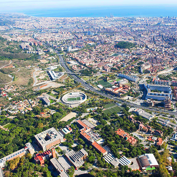
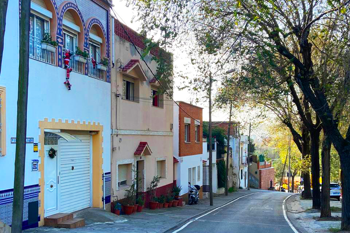
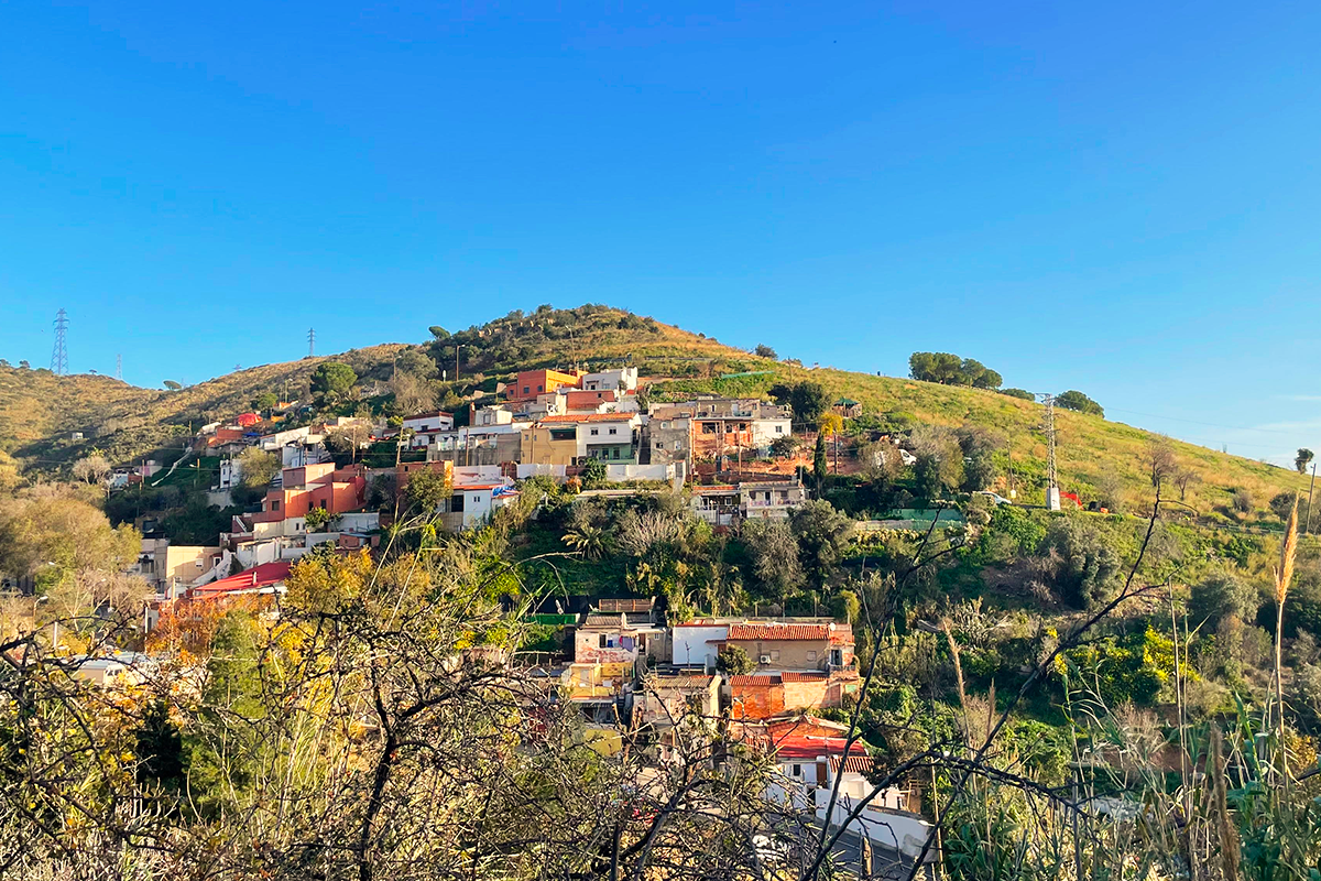
La Font del Gos est un quartier résidentiel situé dans le district de Horta-Guinardó, au nord-ouest de Barcelone et au pied de la chaîne de montagnes de Collserola.
Le quartier est né dans les années 1930, en raison de l'immigration en provenance d'autres régions d'Espagne (qui a créé une demande de nouveaux logements), ce qui a donné lieu à des implantations dans des zones rurales sans planification préalable.
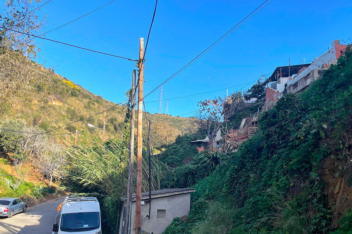
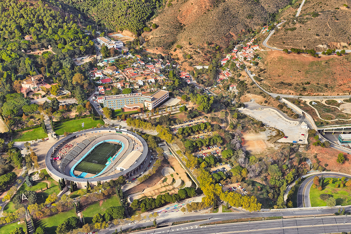
La Font del Gos n'a jamais été officiellement reconnue comme un quartier, une perception influencée par plusieurs facteurs, notamment la construction de la Ronda de Dalt, une route principale qui a créé une barrière physique entre la zone de La Font del Gos et le reste de la ville, en préparation des Jeux olympiques de 1992. À la même époque et dans les années suivantes également, la construction d'autres installations de grande envergure, comme le Vélodrome, a creusé la fracture entre cette zone résidentielle et le reste de la ville. La zone urbaine est située sur la topographie escarpée typique de la zone et se compose de deux rues principales qui suivent le cours d'eau et qui forment les deux principaux quartiers : Cal Notari et La Font del Gos.
Comprenant environ 100 logements et 350 habitants, la zone a été affectée depuis longtemps par le Plan Général Métropolitain et d'autres plans d'urbanisme, qui ont entravé son bon développement et son entretien.
La plus importante de ces affectations est liée à la zone de Cal Notari, classée comme zone protégée du Parc Naturel de Collserola. Dans cette zone, les maisons sont situées dans une zone non constructible et doivent être déplacées ou, exceptionnellement, faire partie d'un système et d'une typologie qui permettent leur localisation dans le Parc Naturel.
Il existe également un manque de services tels que des commerces de base et des équipements de proximité, ce qui oblige les habitants à se déplacer vers d'autres zones de la ville malgré les défis posés par un accès limité et un transport public insuffisant.
Il s’agit d’un quartier de la ville qui se situe à cheval entre les environnements urbains et naturels, c’est pourquoi le site offre des opportunités au-delà du niveau urbain, en s’inscrivant dans un écosystème plus vaste, avec le potentiel d’agir comme catalyseur d’initiatives liées à l’urgence climatique et à d’autres facteurs cruciaux pour les villes modernes.
QUESTIONS AUX CONCURRENTS
Nous pensons avant tout que le projet de ce quartier doit adopter une approche globale et locale, en se concentrant sur le modèle de développement à appliquer dans les espaces à la frontière entre la ville et la nature. Il s’agit d’un contexte « périurbain », où convergent différentes zones aux limites de la ville. À ce niveau local, il est important de considérer la forme et la fonction de ces espaces au sein de l’écosystème plus vaste qui les entoure.
En second lieu, il convient de prêter attention au lien avec la ville et à sa fonction métropolitaine. Quel rôle peut jouer La Font del Gos au sein de la ville et quelles relations interdépendantes peuvent être créées pour renforcer sa connexion métropolitaine ? Comment améliorer les connexions avec son environnement urbain pour faciliter ces relations ? Et avec son environnement naturel ?
Enfin, à l’échelle locale, nous invitons les participants à réfléchir au type de réseaux urbains, d’habitations et d’usages locaux qui devraient définir cette zone pour l’aider à maintenir son identité et son mode de fonctionnement propre tout en servant de limite et d’espace de transition. Quelles sont les caractéristiques de cette limite ? Comment est-elle définie ? Quelles sont les possibilités de réaménagement ? Qu’en est-il des possibilités de renaturalisation ?
Enfin, il faudra analyser la meilleure façon de mettre en œuvre ce nouveau plan, en définissant des travaux à court, moyen et long terme pour assurer sa viabilité et sa durabilité.
Questions à propos du site
Hi, I can't see any mention in the project brief about a site visit. Is there an official date scheduled for a site visit? Thanks.
The visit will take place 7th May. Practical information will be publisehd on the Europen web.
Can the pre-existing buildings be "deleted" from the intervention area and start from scracth?
Project proposals must take into account the degree of the affected areas by the urban planning as well as the state of conservation of the existing houses, as many of them are in good condition. On this basis, participants should make a decision in line with current social and environmental requirements. For our part, any well-justified proposal that demonstrates feasibility will be welcomed in the evaluation process. Best regards,
Is an organized site visit planned for the La Font del Gos site?
The visit will take place on 7 May. We will inform about the time and meeting point.
From the brief we understand that there is a need of new residential building to increase density, but the general topic of competiton is re-new re-source, is it possible to add new residential building to cover this need enlight in the brief of Font del Gos ?
The competition requires guaranteeing housing for current residents of Font del Gos. At the same time, it invites a rethinking of the neighborhood’s role within the broader context of Barcelona. In light of this, while there is no set target for increasing density, proposals may consider it if supported by solid analysis and clear justification. Referencing similar urban contexts in Barcelona is encouraged when assessing feasibility and formulating proposals. The addition of new housing is possible, as long as it aligns with the competition’s vision: re-new, re-source. We hope this helps, otherwise don’t hesitate to contact again. Thank you again. We are looking forward to see your proposals!
North of Centre Educatiu Can Llupià, there is a rectangular plot that appears ambiguously defined—looking like a field in aerial images, but its use is unclear. Could you clarify its current or intended function, and if there are any planned developments or restrictions?
Thank you for contacting us, we are glad to help you! The plot you mention used to be a football field. It is currently out of use and inscribed in a protection area defined in the city's urban plan (Collserola Forest Park). However this does not exclude the possibility of a project-related intervention, as long as it is properly justified. We hope this clarifies your questions, otherwise don’t hesitate to contact us again. Thank you again, we are looking forward to see your proposals!
From the brief we understand that there is a need of new residential buildings to increase density, how many new residents are expected to live in the Font del Gos Barrio?
The competition requires guaranteeing housing for current residents of Font del Gos. At the same time, it invites a rethinking of the neighbourhood’s role within the broader context of Barcelona. In light of this, while there is no set target for increasing density, proposals may consider it if supported by solid analysis and clear justification. Referencing similar urban contexts in Barcelona is encouraged when assessing feasibility and formulating proposals. We hope this helps, otherwise don’t hesitate to contact again.
The 2015 agreement mentioned covering or modifying the Ronda de Dalt in northern Horta-Guinardó. Could you confirm if this project is still planned or scheduled? Should participants design for the current state or anticipate future coverage when working on La Font del Gos?
La Ronda de Dalt is an urban barrier that should be taken into consideration. Its covering project is an approved urban infrastructure project and it is part of the city's long-term planning agenda. However, participants can explore alternative design strategies related to the Ronda de Dalt, as long as it is properly justified. It is important to clarify that the Ronda de Dalt is included within the City Scale analysis area but not within the Project Site. This means it should be considered as part of the broader urban context to be addressed, but not as the primary focus of the intervention. For further information, we attach a link documenting the Ronda de Dalt coverage proposal: https://avsantgenis.wordpress.com/wp-content/uploads/2016/05/proposta-bec-rondadalt-20160510.pdf
Are you going to upload a summary of the site visit similar to other sites? Is it possible to have a report of it? Are there any videos and photos from that day? Was there any major issue addressed during the site visit and what was the discussion around it?
It will be publisehd very soon.
Is it possible to have a 3D model of the area?
You will find a 3D model of any part of the city in this website as well as many other plans and digital models in the following link: https://geoportalcartografia.amb.cat/AppGeoportalCartografia2/index.html
Could you please upload information about drought, floodings and fires that happened lately in the area of interest of close to it? For example a map showing the areas that are most prone to natural disasters.
You will find information regarding the flood risk and other hydraulic data in the following link: https://sig.gencat.cat/visors/VISOR_ACA.html
And the following website shows the Civil Protection Map of Catalonia where you can find the fire risk map and other natural risks maps: https://pcivil.icgc.cat/pcivil/v2/index.html#41.40931,2.12897,6z.
We hope this can be of help to you. Best regards
Do you have any more precise demographic data on Font de Gos and the Cal Notari neighborhoods/area? Except from those on the brief which refer to the whole Horta neighborhood that extends under the highway.
Unfortunately, we don't have any more detailed information about the population of La Font del Gos than what is already published. However, we have included the contact details for the Horta-Guinardó public administration office, in case they are able to provide you with this information.
La Font del Gos also has its own website, where you can find more details about its residents. There is also a book in which the author aims to give visibility to the neighbourhood and which contains a lot of interesting information.
Horta-Guinardó district website: http://barcelona.cat/tramits
The phone number for the Horta-Guinardó district is 931537010.
Font del Gos website: https://fontdelgos.webnode.es/
Font del Gos book: https://adg-fad.org/laus/proyecto/font-del-gos-un-barrio-olvidado-de-barcelona-0/.
We hope this information is helpful to you. Best regards,
Could you please give us more information about the current state and the usage of the parking lot next to the Velodrome, the open parking lot next to the only bus stop in the area, and lastly about the Parc de Xavier Montsalvatge? This last one seems still under construction or abandoned to us through the Google maps imagery.
The car park next to the Velodrome is mainly used by students and people who use the public facilities in the area, such as universities and sports centres. It might be interesting to rethink the use of these parking areas.
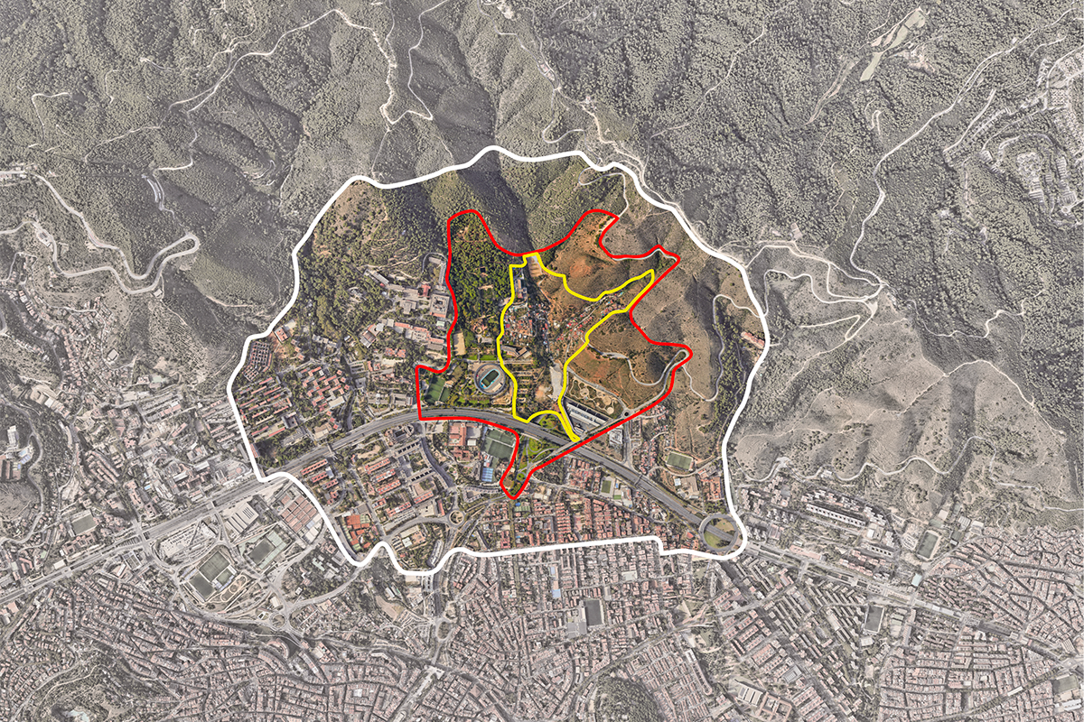
Please find our questions regarding the site: 1. On the map, three lines in different colors (white, red, and yellow) are shown. What is the significance of each line, and how do the areas they outline differ? (eg the strategic masterplan should be considered in the white boundary?) 2. Are there any documents available from the site visit—such as photos, information, or presentation materials—that we could access? 3.Is there a recommended or preferred percentage of buildings that may be considered for demolition?
The colour of the lines refers to three levels of delimitation:
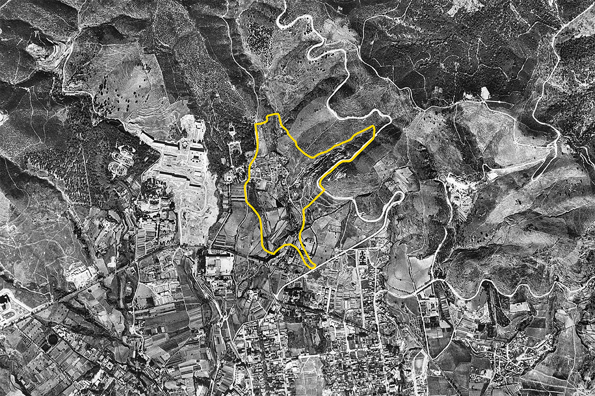
• The project area (yellow line) defines the space in which the project is to be carried out.
• The reflection area (red line) defines the context of the project and may also contain parts of the project.
• The territorial area (white line) contains the different elements of the territory that the contestants will be working on.
On the other hand, the pictures of the site, they have already been uploaded and are available to registered participants. In addition, in the next few days we will upload a video with fragments of the visit we organised for the participants.
And regarding to the houses, it is important to give a solution to the dwellings affected by the PEPNat, but there are no recommendations for demolition. Participants should analyse and propose solutions as long as they are well explained and reasoned.
Could you please give us more information about the current state and the usage of the parking lot next to the Velodrome, the open parking lot next to the only bus stop in the area, and lastly about the Parc de Xavier Montsalvatge? This last one seems still under construction or abandoned to us through the Google maps imagery.
The Xavier Montsalvatge Park is complete. However, due to its location, it has very little use. This is an important issue within the study area, given that the park is in a privileged location and could contribute positively to the city.
Le site est lié au thème suivant
Re-sourcer à partir d’éléments naturels Comment concevoir des processus et des projets de revalorisation des paysages qui prennent en compte les interdépendances et éco-dépendances des ressources (naturelles, culturelles, productives) et du territoire ? La régénération des paysages peut devenir un outil de médiation entre les zones résidentielles, les équipements et infrastructures obsolètes et les territoires en transformation (voire menacés) sous l’effet des effets du changement climatique. Est-ce une invitation à penser les ressources du territoire de manière régénératrice pour soutenir un environnement plus sain pour les humains et les non-humains ?
Régénérer les paysages
Documents spécifiques
Questions à propos du site
Pour pouvoir poser une question, vous devez être connecté (et, par conséquent, inscrit au concours).
Ve. 16 mai 2025
Date limite de soumission des questions
Ve. 30 mai 2025
Date limite de réponses aux questions
Avant de soumettre votre question, assurez-vous qu'elle n'apparaît pas déjà dans la FAQ.
Merci de poser vos questions sur les sites dans le menu Sites.
Merci de poser vos questions sur le règlement dans le menu Règlement.
Si votre question ne reçoit pas de réponse dans les 10 jours, merci de vérifier qu'elle ne figure pas dans la FAQ sous un autre intitulé ; sinon, contactez le secrétariat concerné par email (secrétariats nationaux pour les sites, secrétariat européen pour le règlement.)