Malmö (SE)
Les Dossiers synthétiques et d'enjeux sont disponibles gratuitement.
Merci de vous inscrire et vous connecter pour accéder au Dossier complet de site.
- Dossier synthétique EN
- Dossier d’enjeux EN
- Le site sur Google Maps
- Retour à la carte
Données synthétiques
Malmö (SE)
Échelle L/S
Composition d’équipe Architecte non obligatoire
Localisation Hyllie, Malmö
Population Malmö 360 000 habitants
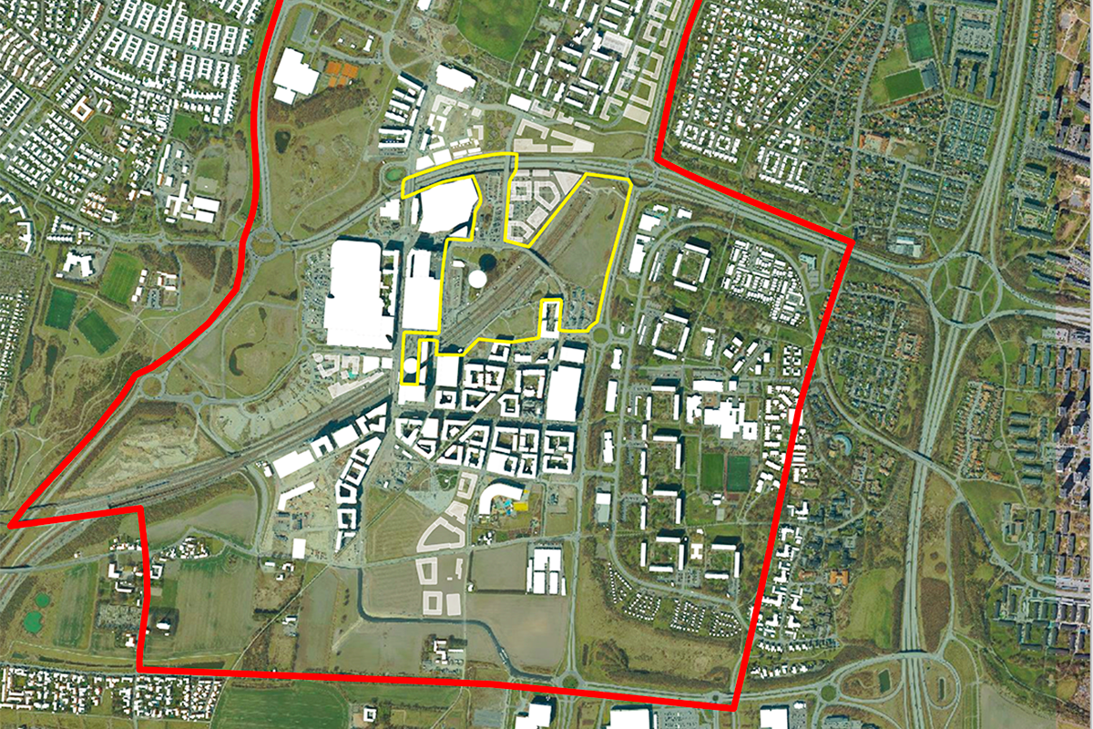
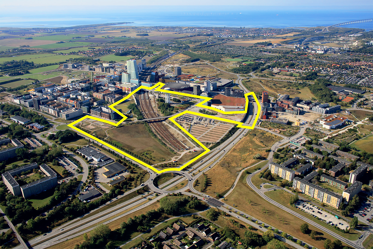
Site de réflexion 4 850 000 kvm - Site de projet 404 000 kvm
Site proposé par Ville de Malmö, Administration suédoise des transports, PEAB
Acteurs impliqués Ville de Malmö, Administration suédoise des transports, PEAB
Propriétaire(s) du site City of Malmö,The Swedish Transport Administration
Phase post-concours Les équipes lauréates poursuivront leurs travaux sur le projet de concours dans le cadre d'un atelier avec la ville de Malmö, l'administration suédoise des transports et le PEAB. Une option de travail continu, comme des ateliers, des présentations, des études spatiales stratégiques, divers documents de planification, des illustrations, des dessins et des dialogues avec les citoyens, peut être envisagée après la fin du concours.
Information complémentaire
SITE / CONTEXTE
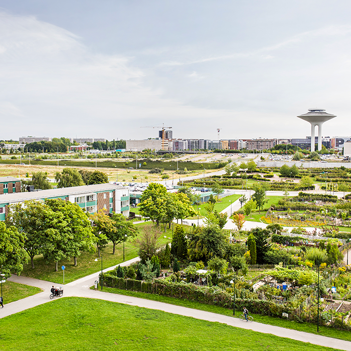
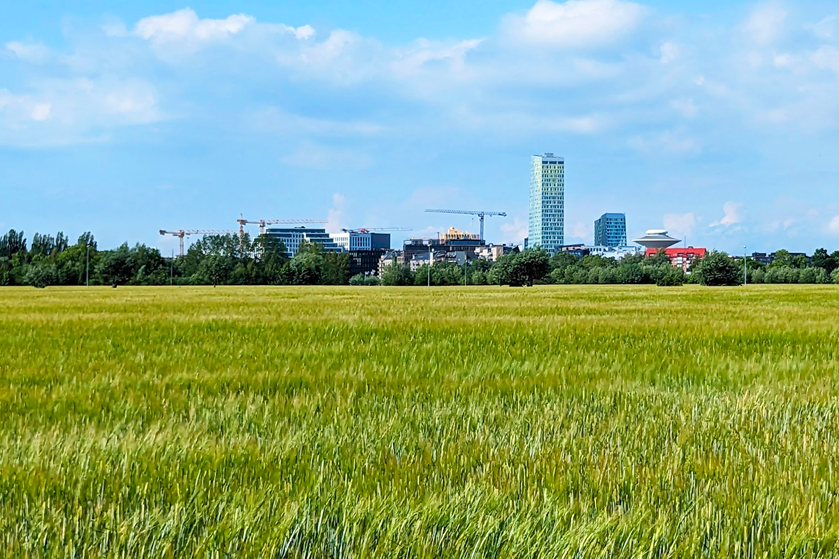
Malmö est la troisième plus grande ville de Suède et une partie dynamique de la région d'Öresund, où la Suède et le Danemark sont reliés par le pont d'Öresund. La ville est passée d'une ville industrielle à un pôle international de développement urbain durable, d'innovation et de créativité. Malmö est connue pour sa population jeune et multiculturelle, ainsi que pour son ambition progressiste de créer une ville définie par l'égalité, la neutralité climatique et le développement durable.
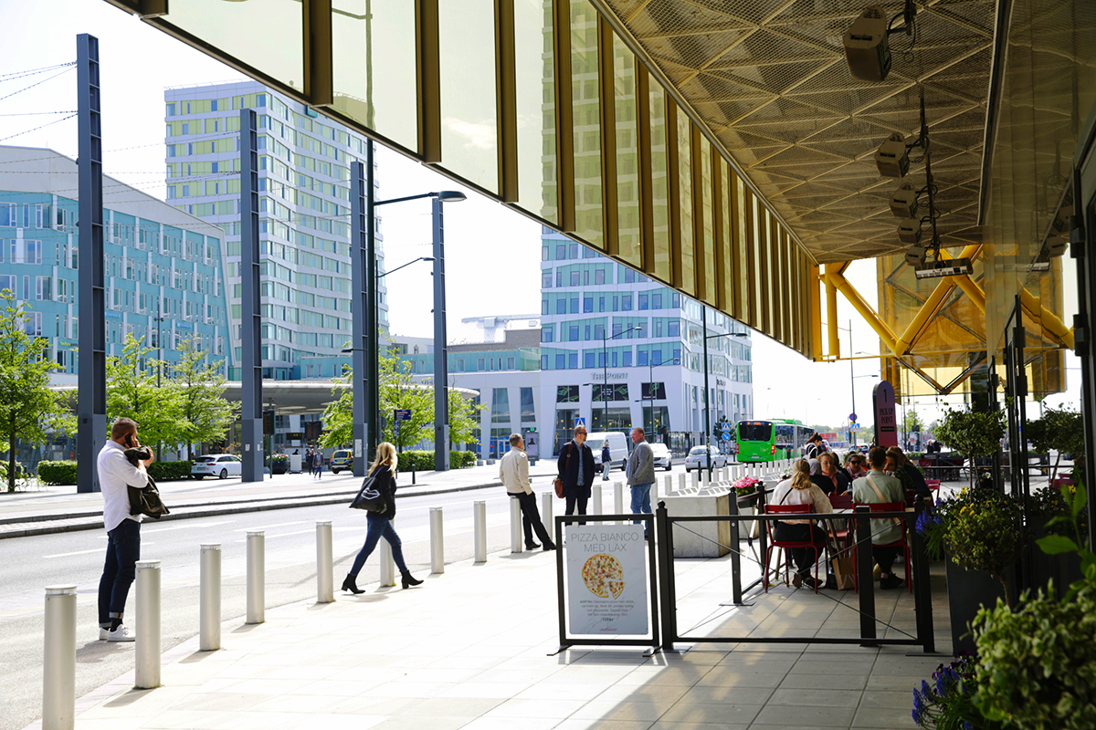
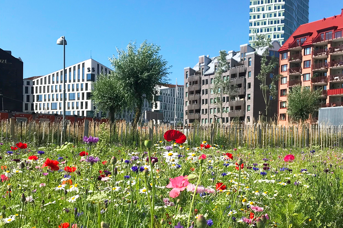
Hyllie est un quartier du sud de Malmö dont l'emplacement stratégique est un moteur des objectifs de durabilité de la ville. La gare d'Hyllie est un élément clé de l'infrastructure régionale et internationale, positionnée comme la première gare de Suède pour les voyageurs en provenance du Danemark. Le quartier est prévu pour devenir le deuxième centre-ville de Malmö, avec un mélange d'espaces de logement, de travail et de loisirs pour 25 000 résidents et 15 000 travailleurs.
Le concours a pour objectif de surmonter les barrières physiques et mentales créées par les voies ferrées et autres voies de circulation majeures. L’objectif est de renforcer les liens au sein d’Hyllie et entre les zones voisines, de promouvoir un mode de vie durable et de développer des idées innovantes et inclusives qui feront d’Hyllie un modèle de développement urbain futur et un élément central de Malmö.
Si le climat doux de Malmö permet de faire du vélo toute l’année, les mois les plus froids et le vent créent des défis pour les espaces extérieurs. Les propositions doivent améliorer l’environnement urbain pour les activités de plein air et l’interaction sociale tout au long de l’année. À Hyllie, le paysage plat rencontre les immeubles de grande hauteur de la ville, ce qui ajoute un défi supplémentaire.
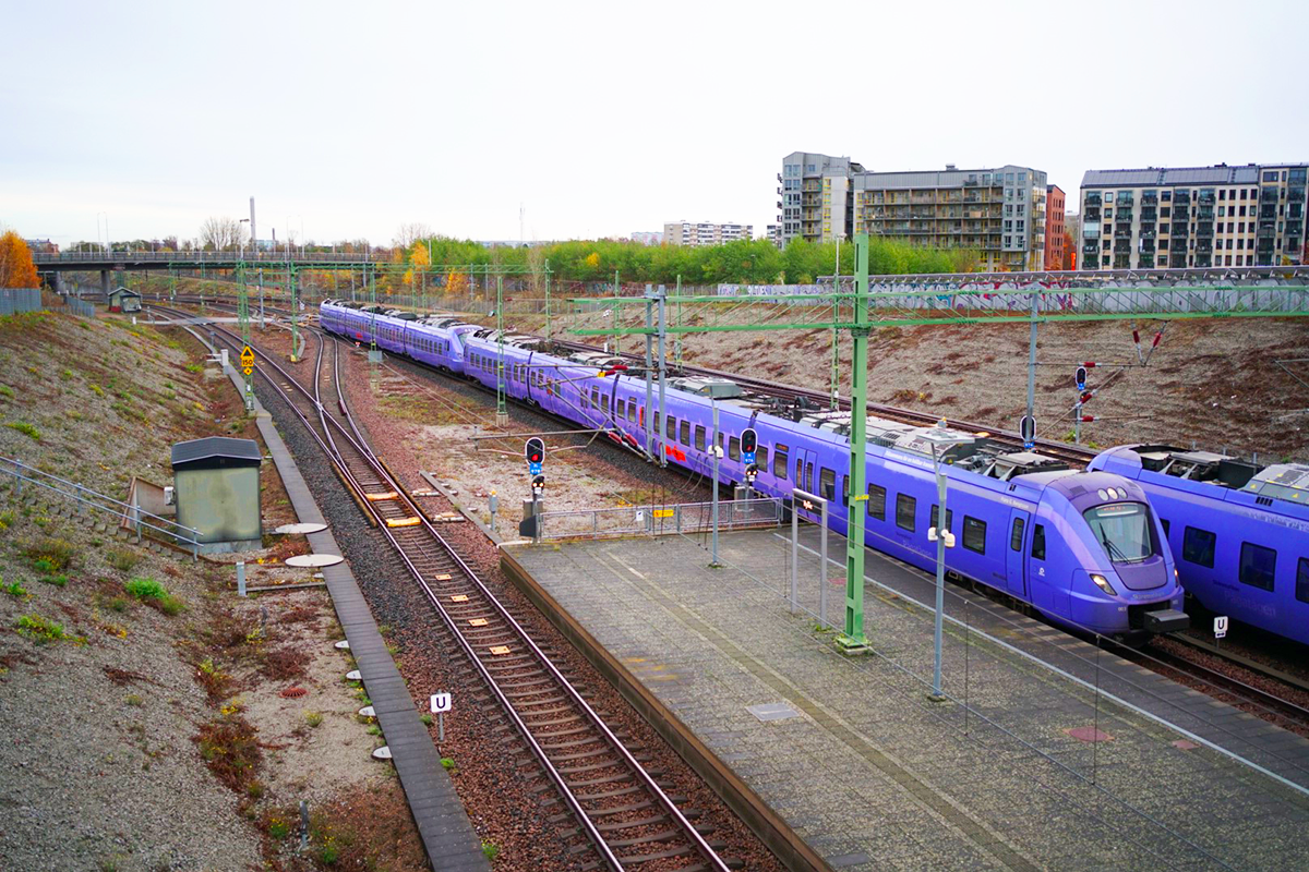
Le développement urbain à Hyllie est désormais « à moitié » terminé, avec 8 000 habitants et 12 000 emplois. Les voies ferrées qui, au début des années 2000, ont apporté une gare et un développement urbain à de précieuses terres agricoles existent désormais dans un contexte très différent. Le périphérique, qui pendant l’expansion de la zone de logements sociaux a servi de sorte de mur d’enceinte de la ville, fonctionne toujours comme un lien clé. Cependant, les quartiers qu’elle divise l’ont désormais placé dans un nouveau contexte spatial. Il est désormais nécessaire de réimaginer ces barrières. La perspective intégrée de la ville et de ses infrastructures est une condition préalable au concours.
QUESTIONS AUX CONCURRENTS
Comment redéfinir l’impact spatial des barrières à Hyllie pour renforcer les connexions - notamment pour les piétons et les cyclistes - entre les zones existantes et planifiées, tout en préservant la fonctionnalité des infrastructures de transport ?
Comment développer Hyllie pour offrir des valeurs et des fonctions sous la forme de plus de culture, de vie quotidienne, de commerce à petite échelle et de restaurants ?
Comment intégrer l’histoire et le contexte culturel du quartier dans la planification urbaine pour renforcer le sentiment d’appartenance et l’ancrage culturel tout en créant un quartier dynamique et durable ?
Quelles solutions de conception innovantes peuvent minimiser les effets négatifs du bruit et du vent, améliorer le microclimat et créer des environnements de vie de haute qualité à Hyllie ?
Comment ces solutions peuvent-elles contribuer à faire d’Hyllie un quartier vert record qui relie de manière transparente la ville, les infrastructures et la campagne ?
Questions à propos du site
As a part of the Site Visit, a future park next to the Malmö Mass is mentioned (between #5 and 6). Can any further details or plan regarding this be shown? And what is the name of the future park?
The name of the park is “Mässparken”. This refers to the adjacent “Malmömässan”, which is the fair hall east of the park.
The park is currently being built and will be finished in December 2026. The park contains a stormwater pond and can accommodate up to 11500 cubic meters of water in case of a cloudburst event. See separate files under "0 New documents after launch/Mässparken". Illustrationsplan_Öster om Mässan , Dp 5530 and Illustration Mässparken 1-3
Is it possible to have the land use map and future plan of the site with full legend?
See file Legend for maps 2D och 3D in the "0 New documents after launch"
Which elements from the site (Infrastructure, Buildings, Topography, Facade) that we can not change ?
Proposals should think of the built environment as a resource, following the competition brief. Still, there are elements that are harder to change (ie. remove, demolish, redesign) than others.
Generally, the competition task specifies that “It is not possible to change the design or function of existing buildings. The urban structure in planned areas is fixed. The functionality and/or capacity of Annetorpsvägen, the railway, and the water tower, including their layout, profile, and speeds, must be preserved.” (p 18). Note that the water tower is a protected object.
Relating to topography, proposals should include thoughts about stormwater management. What the topography of the parks does in terms of functionality needs to be maintained – ie. a redesign that removes this function needs to show that stormwater management is possible somewhere else.
Relating to infrastructure, what cannot be changed is the technical design and capacity of both railway and Inre ringvägen/Annetorpsvägen. When it comes to access roads to the tracks and signalling equipment, it is what these provide in terms of functionality that should be maintained. Note that if ERTMS is implemented on this section of track, the number of technical trackside installations may need to increase (Appendix 2, p 24).
Can we have any information about existing wildlife, such as observed bird/pollinator distribution etc. ?
See file Findings birds pollinators plants in the "0 New documents after launch" folder.
The map is an extract from the Swedish species portal, which is a system for reporting and searching for species observations in Sweden. The yellow dots indicate individual finds and the blue dots indicate clusters. The larger yellow areas are only divisions into different sub-areas. The black rings on the map indicate that there is uncertainty in the accuracy of the location of the observations. Relatively many species observations have been made within the site. This is largely due to the large portion of ruderal land within the site. Of the birds that have been observed at the site, it is worth mentioning the black redstart (Phoenicurus ochruros) and the Eurasian oystercatcher (Haematopus ostralegus). Both of these birds are red-listed in Sweden. Of the flowers, it is particularly interesting to mention the cudweed (Filago vulgaris) and the European violet willow (Salix daphnoides).
What is the existing plan for future green connections in the site ?
They are shown in map SE-Malmo-C-M1 (green connections and park, existing and future) and SE-Malmo-PS-M2, now in the "0 New documents adter launch" folder (parks according to detail plans). In addition, there are no further strategies for green connections in Hyllie or in the study site area. It’s much welcomed if you to do your own analyses and identify connections that are not shown in these maps. We see that it is of extra importance to find solutions that connect larger green spaces with smaller ones - with extra focus on creating connections across the boundaries between the city districts.
How much can we change or modify the use of the water tower ?
The water tower is to maintain its current function and structure. It is a protected object and therefore cannot be changed. Public functions such as restaurants are not allowed. If desired, the lighting, fencing and surfaces surrounding the tower can be adjusted, but need to maintain their current functions.
Given the space between Arena and Hyllie Station is on an overpass above the railway, what is the height, depth limitation e.g. restriction due to utilities underground/weight restriction due to overpass ?
The overpass is dimensioned for its current use, meaning that weight restrictions are reached through how the square is designed as of today – eg. buildings, vegetation, fountains and lights as well as the weight of traffic consisting of private vehicles and buses. Buildings on the overpass are specially designed to fit within the specifications of the structure. No further loads can be added without reinforcing the loadbearing structure.
This also means that the overpass is designed for the context it is in, and therefore not applicable as a template for eventual, additional, overpasses.
Concerning depth limitations, the retaining walls supporting the overpass are supported by a compact backfill with a slope of 1:1,15 (sections A-A and B-B in file A1-30851-A.pdf - Swedish only, in the "0 New documents after launch" folder). This means that approx. 23 meters behind each retaining wall have limitations for larger underground work.
What is the people capacity of the space between Arena and Hyllie Station ? Is there any existing strategy for people movement between the two places ?
When the square was planned, there was a clear request from the police that there should be at least 100 meters between Hyllie station and the main entrance to the Arena. This distance is needed to manage large crowds. There is no exact number for how many people should be able to be in the square at the same time, but it is good to keep in mind that the capacity for the arena is 15,000 visitors. The square should also be able to hold a large part of the visitors if the arena needs to be evacuated.
The fountains and hedges on the square are all lined up in the same direction to facilitate ease of movement between the arena and the train station.
What is the capacity of the car park and bike parking area next to the water tower ? Can we reduce the number and area of car parking at the site ?
The area north of Hyllie parksgatan ( Dp 5530 in the "0 New documents after launch" folder ) is no longer a car park.
It’s important to note that the area next to the water tower is not a car park, but a parking area for buses that is serving both replacement traffic for rail, but also bus transports to the arena. From about 2027, all regional buses to and from Hyllie will operate on Arenagatan. The buses will turn around on the surface. The city is open to a completely different type of bus terminal without small, detached landing islands, but the function and quality must be retained. Soon the city will rebuild this part of the street, Arenagatan, so that it becomes safer for traffic, greener and more adapted for bus traffic. The bike parking is well used by commuters so the number of bike-parking must be retained.
Can we have the detail plan of the constructing park North of site with a big pond ?
See separate file, DP 5530 (in the "0 New documents after launch" folder) för the area next to Malmömässan. For the empty field west of the rails there is no current detail plan.
Is there any regulations or limit in designing the slope buffer to the railway? Will there be any alternative connection to the railway using that slope now or in the future?
Slopes bordering tracks typically have an inclination of 1:1,5-1:3. 1:2 is the most commonly used. For reference, see typical cross-sections in TDOK 2015:0198 drawing 5.3 and 5.10 (Swedish only). For inclinations steeper than 1:1,5, retaining walls are needed.
As of now, there are no plans to remake the configuration of access roads to the tracks. However, as long as the functionality of them (eg. temporary storage of rail parts, access for rail-road vehicles) is upheld, it is possible to design them in another way.
Note that Hyllie station has island platforms, situated between the tracks.
Since we do not have access to all the layers in the Malmö map, we were wondering if you could share the layers with us—preferably in DWG or DXF format—for current land use, as well as a map showing the area's services and functions, such as schools, learning centers, health clinics, shops, and similar facilities.
This information is not available in DWG or DXF format. Please look at the Stadsatlas for information about localisations for those functions. https://stadsatlas.malmo.se/stadsatlas/
According to the brief all the area of Hyllie will accommodate 25000 residents and 15000 workplaces by 2040. Do those numbers include the project site and in that case how many residents and workplaces are expected to be accommodated within the limits of the project site?
The above mentioned figures are guidlines for the whole of Hyllie. They are both indicators of the future size of Hyllie and planning tools that enable the municipality to plan for the number of schools, pre-schools, park areas, etc. that need to be built as the city grows.
There are no specific demands on the project site in terms of number of housing units, office buildings, or other functions. However, contestants should keep in mind that the site is located close to central functions such as public transport, as well as the fact that the site contains valuable agricultural land that should not be replaced arbitrarily.
If you already have an analysis of which services may be lacking in the area, it would be very valuable. Alternatively, if you are not able to share the material directly, we would be grateful if you could refer us to where we can find this data.
We have not conducted any investigations into the type of service or trade that exists within the study area. This is often done in connection with the development of detailed plans. Service and trade are currently very concentrated in the Emporia shopping center. In addition, the main strategy is to supplement with trade mainly along our main streets. Some information about the current situation can be found in the Stadsatlas (schools, preschools, leisure activities, playgrounds, library and healthcare): https://stadsatlas.malmo.se/stadsatlas/
Is the prepared part for decking over Annertorpsvägen calculated for facilitating all types of functions? Does the construction allow for housing/ buildings?
The retaining walls would be able to hold a potential future overbuild with 3-4 story buildings on it.
What is the planned height of the new office building next to Dagvattenparken (Bures gata- Friggs gränd- Regndroppsgatan)?
The building will be 30 meters tall, with some parts lower than that.
What are the plans for Pildammsvägen? According to the existing detail plan the new profile is studied until the Citygross building block. Are there any studies on how the new street profile will extend towards and connect to the roundabout with Annetorpsvägen?
There are plans in place to rebuild Pildammsvägen and give it a greener and more urban feel, with new houses lining it on the west side. The street will both be used as an urban space and keep its function as a main access road, containing four car lanes, as well as separate bike lanes and walkways on each side. The speed limit will be 40 kilometers per hour.
See separate file Principsektion för Pildammsvägen i sin framtida utformning and Pildammsvägen _utformning_240904 in the "0 New documents after launch" folder.
During the site visit it was mentioned that it has been hard to find tenants for the commercial spaces. What is the status today, has the area reached its fulled capacity in retail spaces or are there still empty spaces? If there are empty retail spaces how many are they and where are they located?
In newly built areas, populating commercial spaces can take time, even though many property owners are actively looking for tenants. This is usually due to the fact that there aren’t enough residents. As a result, desired functions such as restaurants and cafés might not be able to establish themselves early on, and commercial spaces are instead inhabited by other types of businesses, such as real estate agents and shops. There is usually a change over time, as more residents move in.
Can you please provide a 3d model including the terrain and buildings? We understand it is available to be ordered from Malmö Stad for a separate fee, great if it can be included in the brief materials, also considering Malmö Stad is one of the involved parties.
It’s now available through the file Hyllie + Holma.skp in the "0 New documents after launch" folder.
Can you please provide high-res aerial and satellite images, but without the yellow and red site boundary lines.
See satellite image named Flygbild 1-7 in the "0 New documents after launch" folder.
Is there an established list of particular deliverables (amount of drawings and specified scales (plans and/or sections), amount of images, diagrams, etc., as we couldn’t locate those under the competition rules - or is it up to participants to decide?
The simple answer is no. It is up to the participants to decide what deliverables describe their proposal in the best way possible.
Are there any height limits for the site and its various parts?
It has previously been established that Hyllie Point will be the tallest building at 110 meters. It may absolutely be appropriate to have tall buildings within the study site, but we would like you to do the analysis and justify where these can be located appropriately.
Any guidance or comments concerning the desired programs for the site, other than it is a mixed use? E.g. is it mostly office buildings with some residential and commercial, or predominantly residential with some office/commercial/cultural, etc.
Hyllie as a whole is planned as mixed use. That does not mean every function needs to exist within the project site, as there are already a variety of existing types of buildings and public spaces around it. Suggestions as to what the site should contain is therefore part of the assignment. Additions should enrich the site and ideally provide services or functions that might be missing today.
Le site est lié au thème suivant
Re-sourcer à partir de la dynamique sociale Une couche d’urbanité manquante s’ajoute sur un territoire aux complexités sous-jacentes. Dans tous ces grands sites, la question est de savoir comment les habiter, comment s’y associer, comment y ajouter un écosystème humain tout en négociant les avantages et les inconvénients de la complexité existante. Il peut s’agir de reconsidérer un développement urbain interrompu, de soigner les blessures laissées ou créées par des infrastructures anciennes ou nouvelles ; de régénérer des logements insalubres ou les dégâts laissés par une friche industrielle, de reconsidérer une rivière ou d’anciens champs agricoles.
Créer de nouvelles relations urbaines
Documents spécifiques

Questions à propos du site
Pour pouvoir poser une question, vous devez être connecté (et, par conséquent, inscrit au concours).
Ve. 16 mai 2025
Date limite de soumission des questions
Ve. 30 mai 2025
Date limite de réponses aux questions
Avant de soumettre votre question, assurez-vous qu'elle n'apparaît pas déjà dans la FAQ.
Merci de poser vos questions sur les sites dans le menu Sites.
Merci de poser vos questions sur le règlement dans le menu Règlement.
Si votre question ne reçoit pas de réponse dans les 10 jours, merci de vérifier qu'elle ne figure pas dans la FAQ sous un autre intitulé ; sinon, contactez le secrétariat concerné par email (secrétariats nationaux pour les sites, secrétariat européen pour le règlement.)