Speichersdorf (DE)
Les Dossiers synthétiques et d'enjeux sont disponibles gratuitement.
Merci de vous inscrire et vous connecter pour accéder au Dossier complet de site.
- Dossier synthétique EN
- Dossier d’enjeux EN
- Le site sur Google Maps
- Retour à la carte
Données synthétiques
Speichersdorf (DE)
Échelle L/S
Composition d'équipe Architecte obligatoire
Localition Speichersdorf, Bavaria
Population 5,907 habitants
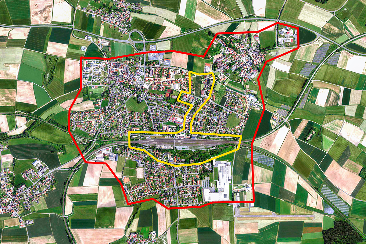
Site de réflexion 245 ha - Site de projet 0,9 ha
Site proposé par Municipalité de Speichersdorf
Acteurs impliqués Speichersdorf, Deutsche Bahn, propriétaires privés
Propriétaire(s) du site Speichersdorf, propriétaires privés, Deutsche Bahn
Phase post-concours Les résultats seront discutés, affinés et développés lors d'ateliers. Les étapes suivantes sont prévues peu après le concours :
1. Une étude de faisabilité structurelle pour la salle des fêtes,
2. Une planification de la station de mobilité, y compris des espaces ouverts,
3. Une planification du cadre de développement urbain pour affiner la zone de la gare et les zones d'aménagement intérieur. La mise en service des équipes gagnantes est souhaitée, mais nécessite l'approbation du conseil municipal local pour toute commande.
Information complémentaire
SITE / CONTEXTE
Pour Speichersdorf, l'objectif est d'identifier et de mettre en œuvre des solutions exemplaires qui renforcent la résilience de la commune face aux changements démographiques, aux bouleversements économiques et aux effets du changement climatique.
Il s'agit de projets modèles qui peuvent servir d'étincelle initiale et de moteur à la transformation de toute la région de Haute-Franconie.
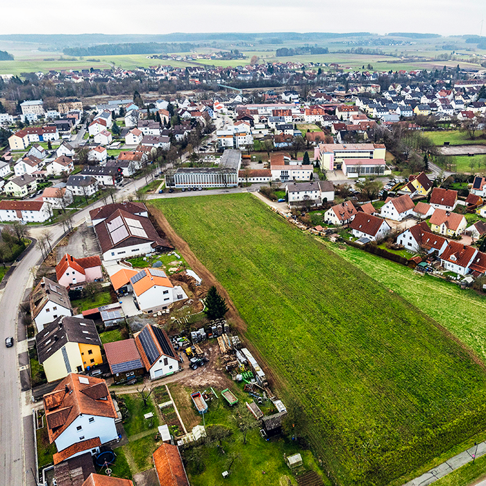
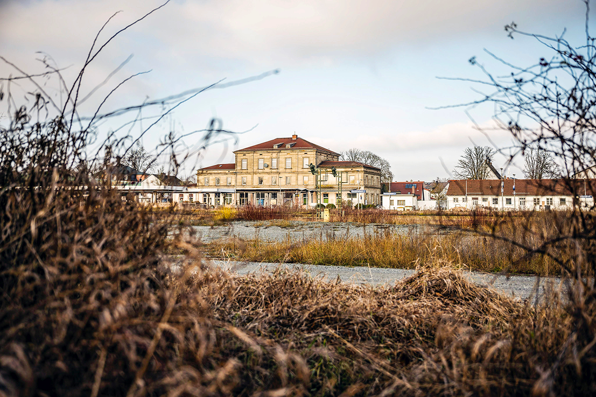
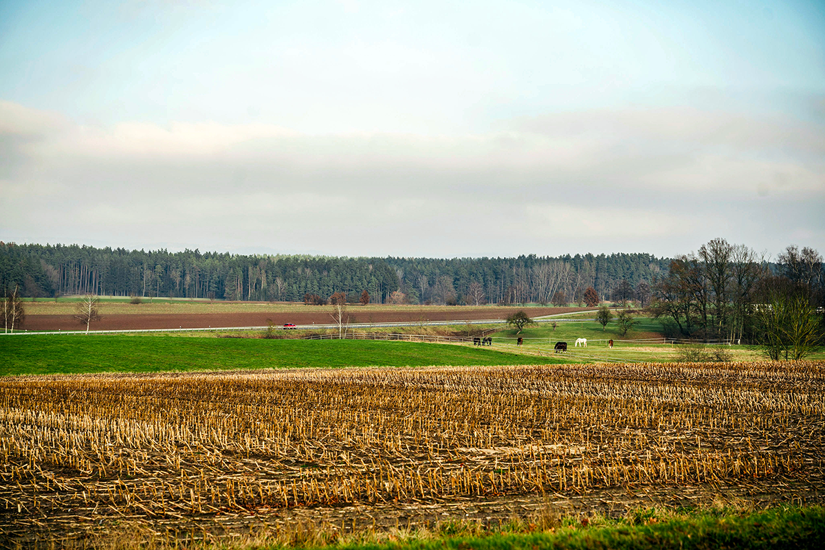
La commune, qui compte 5 907 habitants, est située dans le Haut-Palatinat, dans l'État libre de Bavière, dans le sud de l'Allemagne. Le site est une région de collines légèrement vallonnées avec des prairies et des zones agricoles, intégrées dans des zones forestières.
Speichersdorf fait partie de la région métropolitaine de Nuremberg. Les villes les plus proches, Bayreuth (75 000 habitants) et Nuremberg (518 000 habitants), sont accessibles en train ou en voiture en quatorze et soixante minutes.
Les participants peuvent choisir entre trois domaines à développer :
A) Pour l'ancienne salle des fêtes, des propositions architecturales concrètes pour réorienter la construction de la salle et trouver une nouvelle utilisation pour le bâtiment doivent être élaborées.
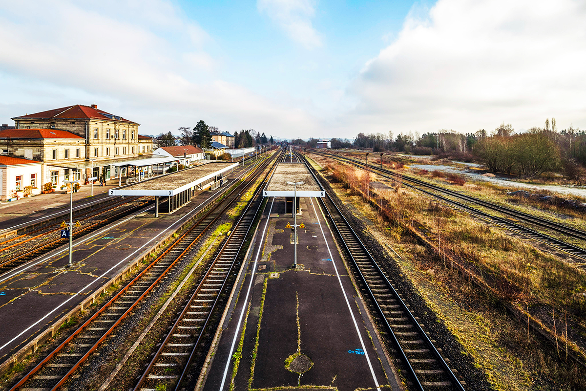
B) Pour la gare historique, des propositions pour un quartier innovant, durable et vivant avec des formes modernes de logements et de typologies de bâtiments et une mobilité alternative sont recherchées.
C) Une stratégie globale doit être élaborée pour les espaces ouverts aux multiples facettes du centre de la commune.
Speichersdorf recherche des participants qui traitent les ressources bâties et spatiales existantes de manière respectueuse et prudente et les développent davantage comme exemple pour d'autres petites communes.
QUESTIONS AUX CONCOURS
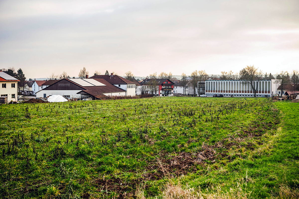
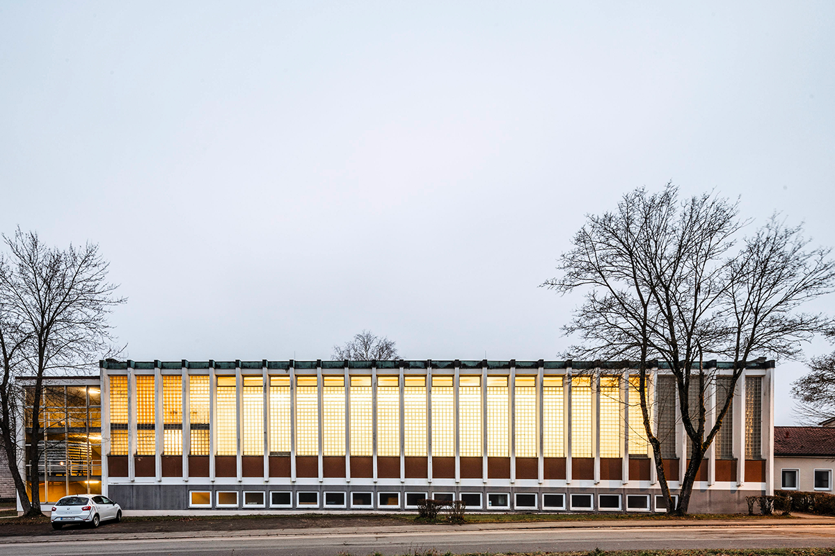
La salle des fêtes comme ressource de construction : Quel potentiel offre la salle des fêtes ? Quelles utilisations sont possibles compte tenu de la structure existante du bâtiment ? Comment les qualités spatiales et les caractéristiques architecturales particulières peuvent-elles être développées conceptuellement et structurellement ? Comment une revitalisation peut-elle avoir lieu avec des interventions minimales et des mesures peu coûteuses ?
Le site de la gare comme ressource architecturale et spatiale : à quoi ressemble un quartier tourné vers l'avenir avec des concepts d'habitat innovants ? Quelles typologies et quels espaces urbains ce développement intérieur nécessite-t-il pour créer des qualités spécifiques ? Comment le site peut-il donner naissance à un lieu identitaire qui relie les deux parties de la commune entre elles ? Comment la gare historique peut-elle redevenir un lieu vivant ? Comment peut-on concevoir un pôle de mobilité avec des espaces de vie attrayants ?
Les espaces libres comme ressource spatiale : quel rôle les espaces libres au sein de la commune peuvent-ils jouer à l'avenir ? Quelle contribution peuvent-ils apporter à des thèmes tels que l'adaptation au climat, la biodiversité et l'approvisionnement alimentaire local ? Quels potentiels de surface peuvent être mis en évidence pour le développement de logements ?
Photographie aérienne : Données géographiques : Bayrische Vermessungsverwaltung, © Bayerische Vermessungsverwaltung 2025, Bundesamt für Kartographie und Geodäsie
Autres photos : Thomas Müller
Questions à propos du site
Is the competition planning for the ‘lively town centre’ to be accepted as ‘as is’? Can the planning be made available as a PDF and DWG?
Yes, it will be in the folder "New Documents after Launch" soon.
What exactly is the ‘Jugendheimverein’ to the east of the railway station area (source: GoogleMaps)?
This is a leisure area that is used by groups who spend leisure time in the nearby Valentin-Kuhbandner-Heim. The area has a small pool, several pieces of play equipment and a beach volleyball court.
A trench has been created in front of the train control tower in the east of the station area in the direction of Danziger Straße. Does this serve to retain the railway tracks in the event of extreme weather events? Should this be preserved and incorporated into the planning?
Yes, this ditch is used for surface drainage of the railway tracks and platforms. It must be preserved and included in the planning.
What equipment/function does the new youth centre/youth club at the primary school have?
The youth centre is not yet equipped. This is another ISEK measure that will be implemented in 2026. It is a meeting place for young people, who are to ‘play’ and organise it themselves. A community youth worker is to be employed to provide guidance and supervision. The specific design is therefore still open and is to be developed together with the users.
We will upload the study on the future youth center in the folder "New Documents after Launch" soon.
The variant without a second level is to be used for the realisation, there is no information on the equippment yet.
Question 1: For task 3 (the railway station), the "Bauprojekte Deutschebahn" website has a 3D model of the station area in the pictures. Can we have that 3D model? Question 2: Where can we find the new pictures and videos of the site visit and the questions and answers made on-site?
Unfortunately, the 3D model of the Deutsche Bahn cannot be made available by the municipality. The DWG file ‘2503012_Speichersdorf_Vorplanung Mobistation.dwg’ can be found under documents after relaunch. This contains the Deutsche Bahn measures in the 2D site plan.
The minutes from the consultation colloquium will be uploaded to the Europan Germany website and the Europan Europe website in the near future. In addition, the film recording of the site visit will also be available on the German Europan website.
Which tracks will be used after the current renovation in the train station, and which will be unused?
The railway tracks are to be included in the future planning in their current form.
There is a mobility concept pdf already in the available project documents. Can this concept be changed in our proposed project? Do our ideas have to comply with this existing mobility concept?
The mobility concept was created from the ISEK in 2024. It therefore maps the needs relatively up-to-date and proposes measures and projects that are now being successively implemented by the municipality of Speichersdorf. This currently primarily concerns the town centre area. However, the concept may be scrutinised and further developed in the europan competition depending on the concept. Suggestions for changes are also welcome!
Is there a development plan for the railway station site? Or is reference made to the BayBO with regard to storey height?
No, there is no development plan. One of the tasks of the Europan competition is to develop a development concept for the station site that is appropriate in terms of density and height.
Is the area for the mobility hub already fixed? Or can a different area be suggested?
The community of Speichersdorf bought most of the surrounding areas in the north of the tracks in the east and west of the old trainstation, in order to realize the mobility hub. (marked in yellow in the plan „11_Eigentumsverhältnisse Bahnareal.jpg“)
Suggestions can still be made for the design of the mobility hub. (vgl. 241021_Speichersdorf-Bahnhof Vorplanung Mobilitätsstation_Arbeitsstand.pdf) The position / area of the mobility hub around the old building of the trainstation is fixed.
For task B, the train station, is the focus on designing the neighborhood on the south of the train station marked with pink, or the whole area including the mobility hub and the old station area on the north should be designed?
Task B – train station area – includes both, the new neighborhood in the south in connection with the mobility hub in the north. The mobility hub gives an important impulse in the development of the whole area and should therefor be included in the design strategy - not only for the area in the north, but also the new development in the south of the traintracks.
A petrol depot is marked on the DB site plan to the south of the tracks - is this still in operation or is it above or below ground?
This is a former petrol depot that has been dismantled. It is not clear to the municipality to what extent buildings or tanks still exist underground. However, increased contamination is to be expected in this area.
The mobility concept mentions that the existing tunnels at the train station will be abandoned - what exactly does that mean? Will the tunnels be filled in?
The individual platforms are currently accessed via pedestrian tunnels. These will be filled in when the new lifts and staircases are in operation and the platforms can be reached barrier-free via the footbridge.
This refers to the pedestrian tunnels - the two road tunnels on the eastern and western edges of the urban area will of course be retained.
When was the pedestrian crossing built? And by whom? How should the idea of widening it for cyclists be dealt with?
The pedestrian bridge was built in 1997 by the municipality of Speichersdorf. The construction work on the footbridge to build the new stairs and lifts to the railway tracks has already been started by Deutsche Bahn. Unfortunately, there are no plans to widen the footbridge for cyclists at this stage. The footbridge will remain as it is, only the access points to the stairs and lifts will be slightly adjusted in height.
What is planned for the small building to the west of the station building?
The building is to be acquired by the municipality and assigned a function in line with the mobility station. According to the mobility concept, ‘bicycle station, lockers, DHL packing station or similar are being considered. (see 241021_Speichersdorf-Bahnhof Vorplanung Mobilitätsstation_Arbeitsstand.pdf) However, other ideas can also be developed in the competition.
The small building to the east of the station building is to be demolished. Ideas can also be developed here.
Are there any plans to merge the two fire brigades?
The fire service concept approved by the municipal council in 2024 envisages merging the two fire services in Speichersdorf and Kirchenlaibach in the coming years and building a joint fire station in 2035. In the ISEK, a location to the north of the shopping centres is planned for this, provided that land can be acquired there.
Is there a structural analysis of the festival hall or other as-built plans that show the roof or supporting structure in more detail, for example?
No, unfortunately there are no further documents for the festival hall.
Note: In addition to the current CAD survey of the festival hall, the construction plans for the school extension from 1991 have also been attached as a PDF under ‘12_OTHER BASIC DATA AND INFORMATION FOR PARTICIPANTS - PROJECT AREA’.
Thank you very much for the reply to my question regarding additional plans of the festival hall. Unfortunately, I can't find any document fitting to the description (‘12_OTHER BASIC DATA AND INFORMATION FOR PARTICIPANTS - PROJECT AREA’.) Could you provide more information on where/how to find that document? I am very sorry for any inconvenience.
Thank you for your question, we added the 4 plans of the existing schoon building to the folder "New Documents after Launch".
Is there a 3D model of (parts of) Speichersdorf that you can provide us with? Or do you have a suggestion where we can download such a model (Geoportal Bayern, etc.)?
3D data such as terrain models and 3D building models (LoD2) can be downloaded free of charge from the Geoportal Bayern at the following link:
https://geodaten.bayern.de/opengeodata/
As the submission requires three posters DINA1: If more than one topic is explored in greater depth - as required on page 31 in the EN brief “A spatial deepening is subsequently supposed to be elaborated for at least one of three resources (railway area, festival hall, open spaces)“ - would it be possible to submit an additional poster?
As the European regulations stipulate three A1 posters, this cannot be deviated from.
Is there a current forecast of the extent to which the Rosenthal company is expected to continue to operate at the Speichersdorf site and what space requirements are anticipated?
Unfortunately, it was announced in February 2025 that Rosenthal will be closing its production facility in Speichersdorf at the end of 2026. In this respect, the question currently arises as to what role the vacated commercial space can play in terms of urban development in Speichersdorf in the future.
Is the waste heat from Rosenthal's production halls currently being utilised?
No, the waste heat from Rosenthal is not currently being utilised.
Looking at the design perimeter, how high is the proportion of rainwater that is/has to be discharged into the sewerage system?
The proportion of rainwater that is disposed of via the sewer system is not known. The municipality is currently investing in comprehensive measures to upgrade its wastewater system (including a separation system and buffer storage) with the aim of discharging the treated rainwater into the streams in the municipal area.
Are there pure rainwater infiltration areas in Speichersdorf?
Rainwater infiltration areas are planned for the new town centre. There are no other known infiltration areas in the area.
Could you provide us with plans for the new residential development in the north of Speichersdorf?
The urban design and development plan will be made available. (see Folder New Documents after Launch, ‘Living on Laibacher Weg’)
When working on the station area, a site plan section at a scale of 1:500 is required. Can a section be freely selected, since the entire area doesn't fit on the poster?
Yes, the position of the section can be freely selected depending on the concept
Regarding the mobility hub: Can information on capacity be provided? Are there any plans or requests for the number of car and bicycle parking spaces?
The preliminary planning for the mobility station will be made available. (see folder: Documents after Launch, ‘Mobility station_preliminary planning’)
Le site est lié au thème suivant
Re-sourcer à partir d’éléments naturels Dans cette famille de sites, le potentiel des sols pourrait guider l’évolution d’un site dans un processus de régénération, d’intensification ou d’agrandissement de l’espace. La dimension biologique des terres disponibles pourrait déclencher de nouvelles relations écologiques et sociales, et des interactions entre organismes pour un bénéfice mutuel. De l’horizon à l’échelle du micro-organisme : quelle est la capacité des sols à infiltrer la biodiversité, à fournir des services écosystémiques et à donner une continuité au territoire ?
Réactivation des sols
Documents spécifiques
Questions à propos du site
Pour pouvoir poser une question, vous devez être connecté (et, par conséquent, inscrit au concours).
Ve. 16 mai 2025
Date limite de soumission des questions
Ve. 30 mai 2025
Date limite de réponses aux questions
Avant de soumettre votre question, assurez-vous qu'elle n'apparaît pas déjà dans la FAQ.
Merci de poser vos questions sur les sites dans le menu Sites.
Merci de poser vos questions sur le règlement dans le menu Règlement.
Si votre question ne reçoit pas de réponse dans les 10 jours, merci de vérifier qu'elle ne figure pas dans la FAQ sous un autre intitulé ; sinon, contactez le secrétariat concerné par email (secrétariats nationaux pour les sites, secrétariat européen pour le règlement.)