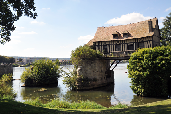
Vernon
The Synthetic Site Folder and Site Brief are available for free.
Please register and login to access the Complete Site Folder.
- Synthetic site folder EN | FR
- Site on Google Maps
- Back to map
Data
Category Urban - environmental - architectural
Location Vernon (27200)
Population CA des Portes de l'Eure 60,500 inhab. - Vernon 25,000 inhab.
Strategic site 1,770 ha - Project site 220 ha
Site proposed by City of Vernon
Owner(s) of the site Various
Commision after competition urban study, management of one or more architectural projects. team representative : architect and/or urban planner and/or landscape architect
Team representative architect - urban planner - landscape architect
More Information
How can the site contribute to the adaptable city?
The site presented here includes a major part of the centre city. It should integrate and reinforce the policy begun by the municipality to improve the Seine Axis. Rooting the amenities of the inner city in a development of those naturel spaces that shape its context, large landscapes marked by typography and hydrography, is essential. This new equilibrium between city and nature doesn’t preclude an intensification of urban activities facilitating conciliation and consistency between urban structural elements and an evolution of uses and practices to attract a new population. Urban transformations need to be considered in contexts of actors and resources, with limited means and in an era of the post-carbon city, calling for efficient management and a pooling of spaces and community facilities.
Restore through identity and uses an urban coherence to the city’s motley grouping of neighbourhoods that public space barely manages to hold together, is also to postulate on the future of open development proposals that include sociological developments and long term innovation.
To make the city an attractive place to live, to develop longer-stay tourism and a make it a seductive, undeniable milestone for people visiting Giverny.
City strategy
The city, located on the edge of île de France in a context of major upheaval (arrival of major transport infrastructures, RER and SNCF), needs to reconcile its structural elements (infrastructure, landscape heritage, urban heritage) justify a vision of development that is specific, visible but measured.
At the heart of the Seine Axis between Paris and Rouen, issues of territorial development are numerous: developing infrastructure, attracting and developing economic activities, promoting tourism, reappropriating the banks of the Seine, recovering the industrial-military brownfields, maintaining the commercial fabric of the city centre, attracting new populations, controlling urban sprawl.
A complete understanding of the transformation of the banks of the Seine is part of the agenda, embodied in the organization of an international competition for urban planning and development for the area of the banks of the Seine. New urban forms are prescribed which seek to enhance the natural landscape in an ecological approach.
The CAPE and the Commune within the framework of Europan are partners in an ambitious policy favouring the study of long-term development for an urban project covering a territory between the Seine and the railway tracks. It will restore a coherency to all the neighbourhoods involved and breathe a genuine revival into the urban fabric through proposals for the transformation of public spaces as well as the built environment.
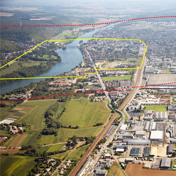
Site definition
The commune of Vernon lies along both banks of the Seine crossed by a bridge with heavy traffic. Incorporated in CAPE, it is about 45 minutes by train from Paris Gare St-Lazare and 30 minutes from Rouen.
The ambitious policy of planned urban development responds to contemporary needs based on the following findings:
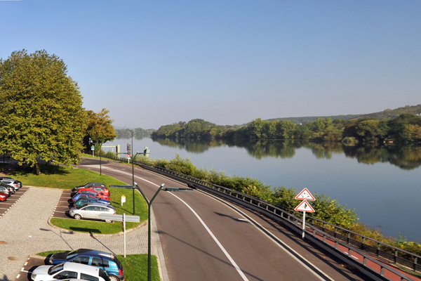
- Within the study area, the Seine River and its banks have very little impact on the life of inhabitants and visitors; it is strange how "the river runs through the city without stopping". The entry points to the city are being reorganized. The highways along the Seine and rail lines to the southwest produce continuous urban breaks.
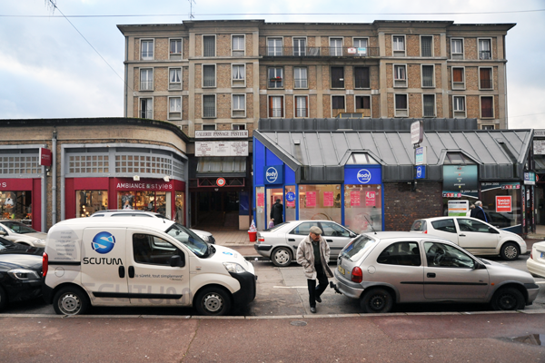
- Within the project area, the neighbourhood around the train station is in poor condition and has to be transformed. The public areas are notoriously lacking in definition, their image and uses are confused.
The urban fabric is punctuated by heritage buildings and has a certain quality. Nevertheless, there is a general feeling of a motley atmosphere resulting from urban sprawl. The city centre, rebuilt after the war, is deplorable, even congested and sometimes dilapidated. The relationship to the Seine and its banks is not serene.
The recovery of the banks of the Seine and the transformation of the city centre neighbourhoods would have actual repercussions for lifestyle and activities proposed by the city. The station and the surrounding neighbourhood (second most frequented station in Normandy and main arrival point for 600,000 visitors a year to Museum of Giverny) are to be rethought in an emblematic way. Reconstruction possibilities through original approaches adapted to the complex urban identity can renovate the too out-dated image of the Centre.
Future of the site in relation to the site family and to Adaptability
To reveal the potentials of the city while respecting the integrity of the existing and to elaborate proposals capable of setting into motion the changes, applicants are encouraged to identify and seize the levers that are going to give added value to the site.
To invent a innovative dialogue between existing city productive of energy and uses and the nature city, to better organize the tensions between local and trans-locales activities, by taking the measure of the possible effects of one on the other, they will propose strategies open to phases of projects adaptable or even reversible. From this context, the long-term scenarios will be extracted.
Today "traversed" for functional reasons, (the D.6015, the bridge, the gardens of Giverny), the city is committed to a brave urban policy seeking, in a context of limited resources and means, a balance between housing, amenities, shops, leisure activities, in order to better attract a young and active population.
The location of Vernon on both banks of the Seine encourages a better sharing of identity, a more affirmed connection between neighbourhoods, covered in the study site. The project site identifies the specific themes to federate.
- Give priority to a possible appropriation of the Seine by the population (quality of the banks and natural setting), which will impact the urban fabric and lives. Public space and the network of city centre streets, fertile supports for enhancing the urban space, the successive sequences of voids and their porosity can, on various scales of intervention, be remodelled.
- Punctual intervention on projects, buildings or conversion of buildings will improve the built environment.
- Finally, to establish a new urban hub around the train station and program an urban renewal satisfying the expectations of the users, exploring scenarios that create new links between neighbourhoods and adopting resilience as an issue in this context of major upheavals.
- The work calls for a dialogue with the future laureates on the subject of the banks of the Seine, seeking a shared, coherent and operational strategy.
Questions on the site
The land registry .dxf file given bugs several computer when we try to open in with Autocad. Does this issue come from us or has it been also raised by other team ?
A new .dwg file has been uploaded online.
A new .dxf map has aslo been added.
May we have a map of Vernon in .dwg file as discussed during the visit?
A new .dwg file and a new .dxf map have been uploaded online.
Is it possible to have a DWG file of the topography of the city of Vernon matching the file « Vernon_Cadastre » provided with the competition’s material ?
A global topographic map of the city doesn’t exist. However, it does for several sites. May you precise to allow the city to check if the desired area is covered ?
Can we have the topographic DWG plan of the Vernon railway station, the banks and the former foundry-stationery?
We'll put on line all we have about that.
Is it possible to get the map of the barracks Fieschi eco-neighborhood (in .dwg)
We'll put on line all we have about that.
Do we have to take into account the coming planning of the barracks Fieschi eco-neighborhood ?
yes
Is the LGV Normandy project well suspended for now on ? only the first part until Mantes seems granted, are following choices coming ? Will the LGV go through Evreux, Vernon or between them ?
The LVG’s infrastructure will not impact the communal territory.
However, it will be inevitable side impacts on the uses of the current infrastructure.
Nevertheless, at the present time, we don’t have practical elements to anticipate them.
Is it clever to bury the railway, has the city already thought about it (especially in case of an LGV passing in the center)?
Why not, if you find a way to fund it. This solution, however, seems utopian.
Concerning Hebert’s city block, should it remain accommodation? Social housing? For sale: may we consider any program? Is it possible to demolish the buildings?
Make your proposal; you are free to take actions on this site and to explain your choices. Don't restrain yourself.
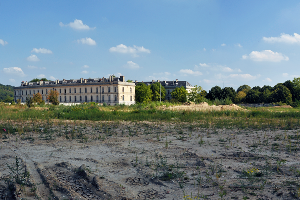
Concerning the proposed sites, especially the stationery and the foundry, is there any detailed study on those sites? May we have access to them?
Studies on this site do exist. Please, precise your needs by writting us at contact@europanfrance.org.
Concerning the crossing of Albuféra street/ Barette place. In which extent can we take action on the existing building, may we demolish part of them? Which ones?
Make your proposal, you are free to take actions on this site and to explain your choices. Don’t restrain yourself.
Do you have other aerial photograph from the city and surrounding (at a larger scale) shot with a 45° angle? If yes, may we have some? If not, but you are aware that, this type of documents already exists, do you know any way to get them?
We do have some semi aerial pictures. We upload them online at a good quality level even if we think they don’t fit your needs. However, we recommend you to consult the work of private photographer Francis Cormon, available on his website.
Concerning RFF. How to contact RFF to have more information about their land. May we contact them directly? Or should we use a mediator? Do you have more accurate document to give us?
What documents do you need? we will do the middleman. contact us at contact@europanfrnce.org
Are we right in assuming that the proposal may include all the 'zones d'attentions and 'sites d'opportunité' but can also concentrate on one or some of them in particular? The scale and type of the presentation is therefore completely up to the participants?
You can focus on one or several ‘zones d’attentions’
It is however recommended to include all the ‘zones d’attentions’ in the urban proposal. Then you may zoom in one or several of them.
In any case, the reflexion scale and the presentation’s type are free. The candidates have to judge what is the most pertinent to do.
This site is connected to the following theme
How to use new inputs to change urban space? How to profit from new inputs to transform urban space and disperse the incoming positive dynamics to adjacent areas to create new urbanities? How to manage potential tensions between the local and translocal activities? These inputs are related either to new public transport network connections or to new programmatic developments. The scale of these incoming urban dynamics varies from the urban agglomeration to the whole world.
Specific documents
E13 FR - Launch: Bondy, Montreuil & Vernon
Questions on the site
You have to be connected –and therefore registered– to be able to ask a question.
Fr. 16 May 2025
Deadline for submitting questions
Fr. 30 May 2025
Deadline for answers
Before submitting a question, make sure it does not already appear in the FAQ.
Please ask questions on sites in the Sites section.
Please ask questions on rules in the Rules section.
If your question does not receive any answer in 10 days, check the FAQ to make sure the answer does not appear under another label or email the secretariat concerned by the question (national secretariat for the sites, European secretariat for the rules).