Borkum (DE)
The Synthetic Site Folder and Site Brief are available for free.
Please register and login to access the Complete Site Folder.
- Synthetic site folder EN
- Site Brief DE | EN
- Site on Google Maps
- Back to map
Data
BORKUM (DE)
Scales L/S
Team representative Architect, urbanist and landscape architect
Location Borkum, Kurviertel
Population 5160 inhabitants
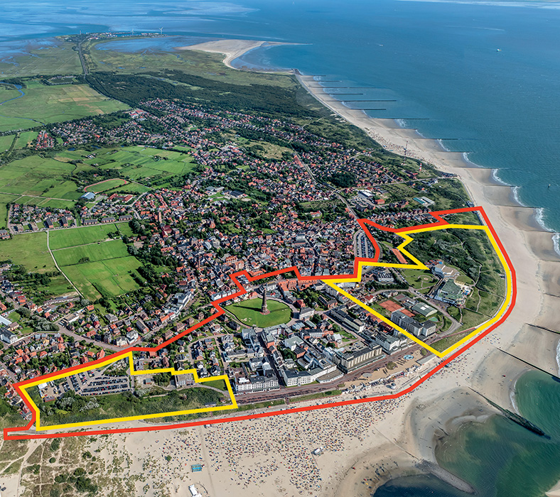
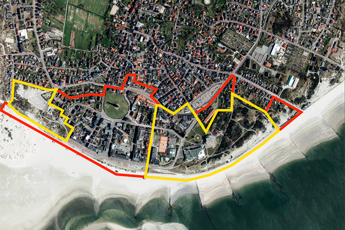
Reflection site 45 ha - Project site 18 ha, 4,5 ha
Site proposed by City of Borkum
Actors involved City of Borkum, Nordseeheilbad Borkum GmbH
Owner(s ) of the site City of Borkum
Commission after competition In the on-site workshops after the competition, the results are to be discussed on site and adapted if necessary. The next planned step is to commission the winning team(s) with urban planning studies.
More Information
Inhabited milieu's challenges
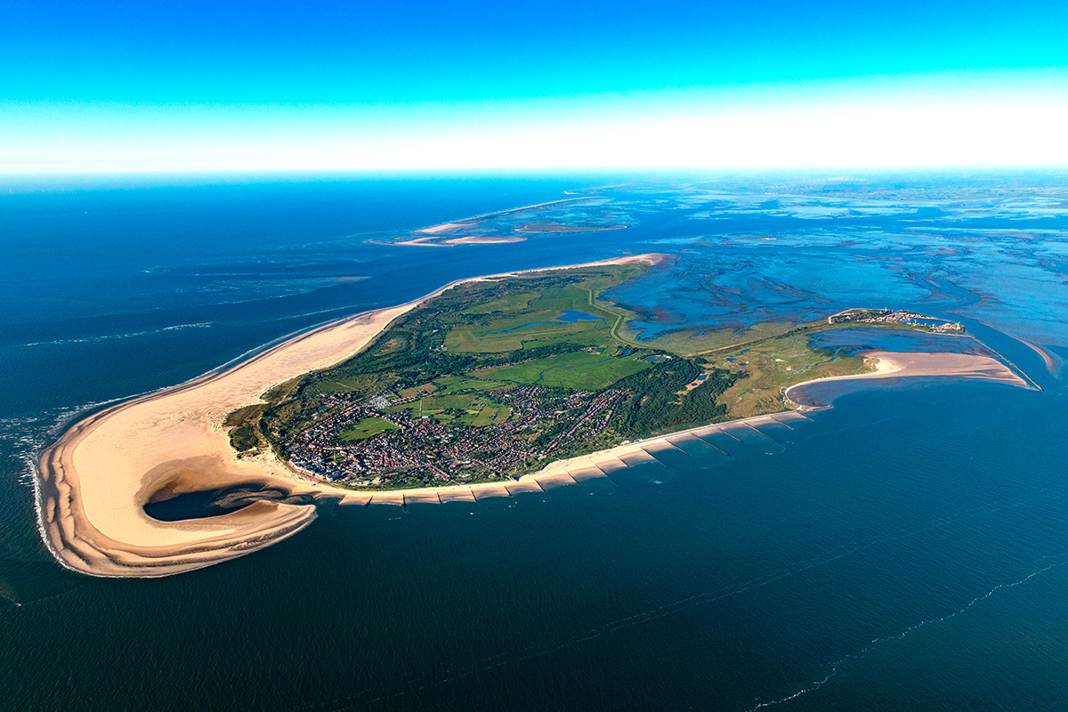
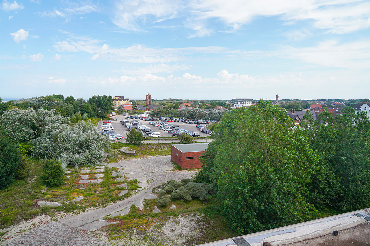
The North Sea island of Borkum, located in the Wadden Sea Nature Reserve and with an area of 31 km2, is the largest of the seven East Frisian Islands and consists of three districts: in the east, there is the «Reede» with its port area, in the west the district «Borkum» with the most important tourist offers, the town hall, and most of the island’s inhabitants. In between, there is the district «Ostland», which is characterized by nature and has extensive dune areas with a diverse flora and fauna, making Borkum the most species-rich island in the region.
Around 5,000 residents live on Borkum all year round, and in the summer months, around 300,000 visitors (2.4 million over- night stays) come to the island, making tourism and its related businesses a strong economic factor.At the same time, tourism poses great challenges: it requires a correspondingly variable infrastructure, as well as many seasonal workers. This results in a shortage of housing - for islanders, but especially for seasonal workers.
Further challenges include the backlog of development and renovation, especially in the «Kulturinsel» (cultural island) located in the project site 1, as well as in the public spaces and the historic spa park. In addition, Borkum has set itself the ambitious goal of becoming an emission-free island by 2030 and must make adjustments to the impending climate change in the coming years.
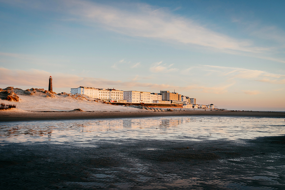
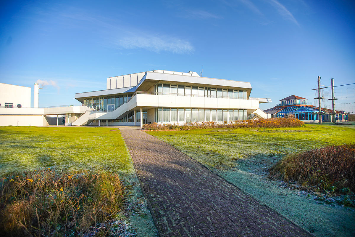
The spa district, with its historical and culturally significant spa architecture from the 19th century, houses the most important spa and cultural facilities as well as hotels and leisure activities and is the flagship and unique selling point of Borkum.
Questions to the competitors
How can Borkum continue to develop its tourism and create structures, uses, buildings, and open spaces that offer added value for visitors, health resort guests, and residents alike?
The Europan task is to develop a new programmatic and spatial perspective for the spa district that does justice to the impor- tance of the place and offers a multifunctional mix of uses that is inclusive of guests and residents.
How can recreation, leisure, and healthcare be developed in a future-proof manner for all? This requires a spatial and content- related restructuring in project areas 1 and 2, which includes various types of housing as well as hotel and cultural and spa offers both indoors and outdoors. How can the range of leisure activities be expanded, even for the off-season and bad wea- ther days? Where could event spaces, the visitor center of the national park, an information center of the city, and a small library be housed - and how can these be thematically and spatially linked? Mixed and flexible structures must be provided that can be adapted to different needs and are thus future-proof.
How can the two project areas be better connected to the spa district and the rest of the city?
What does the future hold for the «culture island», which dates back to 1977 and is in need of renovation? Will it be revita- lized, expanded, renovated, or completely rethought? In this context, life cycle costs and recycling of building materials should also be considered. How can the underutilized Kurpark (spa park) be made sustainable and attractive for visitors?
What do open spaces look like that are attractive to different groups and contribute to climate adaptation? What contribution can the project areas make to improve the climate balance?
Questions on the site
Within the study area (red), two project areas (yellow) are marked. Does each team have to choose and focus on one project area, or is it also possible, not to concentrate on a specific project area but to develop a comprehensive urban concept for the entire study area?..
As described in the submissions (specifications, page 53), an exemplary section of a project area must be shown at 1:500. You can decide for yourself how large this section is in terms of area and what exactly is shown. An overall urban development concept is generally desirable.
For the submission (see letter page 53), an "exemplary section of the chosen project area" is required on a scale of 1:500. In this case, would it be possible to deviate from the given scales, for example depicting the entire red zone at a scale of 1:2500?
It is not possible to deviate from the scale. However, "exemplary section" means that you do not necessarily have to show the entire area at 1:500, but only the part of it that you consider particularly relevant / have studied in depth. If you show a general overview of the project area, they are free to choose a scale for this.
It is required to provide an "exemplary section of the chosen project area at a scale of 1:500" (see letter page 53). It is difficult to fit the entire northern project area at a scale of 1:500 on an A1 plan. Would it be possible to deviate from the given scale?
The relevant part must be shown as an example at 1:500. Which part this is and how large this part is in terms of area can be defined by you. In addition to the defined outputs, you are free to show further representations at scales of your choice.
According to the NIBIS map server, the Turmplatz and the surrounding pathway around the new lighthouse are under monument protection. Is it allowed to redesign the area?
As this is an ideas competition, ideas for this part of the city are also permitted. A separate competition for the redesign of the Tower Square is to take place indirectly. In addition to the lighthouse itself, the enclosing hedge in particular is protected as a historic monument, so it should be preserved. The sealed square is also a listed building and should be kept free so that the lighthouse can be shown to its advantage. Any proposed changes should be agreed with the listed building.
Is the "Spielinseln" house currently intended only for tourist use or is it also accessible to the island's residents?
The play island can be used by visitors as well as residents of the island. It is a house where children can play and do handicrafts. It is open to all.
On the "Ground Floor Uses" plan (see letter page 37), Sonderwohnform and Beherbergung are indicated. What is meant by "Sonderwohnform" and "Beherbergung " in this context?
The buildings shown in red on page 37 are staff residences for spa clinics. The buildings marked "accommodation" are existing accommodation establishments (e.g. hotels and guesthouses) in which accommodation predominates on the ground floor. The map shows the use on the ground floor.
7. Does the green area next to "Haus Meerblick" on Jann-Berghaus-Straße need to be preserved, or is it possible to redesign or develop it?
An open space concept can be drawn up for the "Gründliche" if your design provides for this.
What is the approximate height of the following buildings: Play Island, Culture Island, EmsAG workshop, carriage shed next to the workshop, engine shed (south of the car park), Gezeitenland, Building "Seeblick"
The hights are approxematly:
Play island approx. 12.00 m
Culture island approx. 17.00 m
EmsAG workshop hall approx. 9.00 m / chimney approx. 15.00 m
Carriage shed next to the workshop approx. 7.00 m
Engine shed (south of the car park) approx. 5.00 m
Tidal land approx. 12.00 m
Block of holiday flats "Seeblick" approx. 21.00 m
This site is connected to the following theme
THINK TABULA NON-RASA! Some nature reserves around the world are deserts –hot or cold–, but they host all kinds of animals and microorganisms hiding in the cracks and crevices, under the rocks. Some of our sites look empty, vacant, but they are not. They are full of life: in the soil, in the air, in the breeze. They are part of a larger balance of natural forces and processes. On these sites, substantial new volumes of programme are required. Think of these sites as the opportunity to multiply the number of life forms, think of the request to build new habitats as an opportunity to design a holistic environment. Think tabula non-rasa!
Designing new habitats as a holistic environment
Specific documents
Questions on the site
You have to be connected –and therefore registered– to be able to ask a question.
Fr. 16 May 2025
Deadline for submitting questions
Fr. 30 May 2025
Deadline for answers
Before submitting a question, make sure it does not already appear in the FAQ.
Please ask questions on sites in the Sites section.
Please ask questions on rules in the Rules section.
If your question does not receive any answer in 10 days, check the FAQ to make sure the answer does not appear under another label or email the secretariat concerned by the question (national secretariat for the sites, European secretariat for the rules).