Grenoble Alpes Métropole (FR)
The Synthetic Site Folder and Site Brief are available for free.
Please register and login to access the Complete Site Folder.
- Synthetic site folder EN | FR
- Site Brief EN | FR
- Site on Google Maps
- Back to map
Data
GRENOBLE ALPES METROPOLE (FR)
Scales XL/S
Team representative Architect, urbanist and landscape architect
Location Grenoble Alpes Métropole - Isères (38)
Population City 158.454 inhabitants, Grenoble-Alpes Métropole 443.123 inhabitants
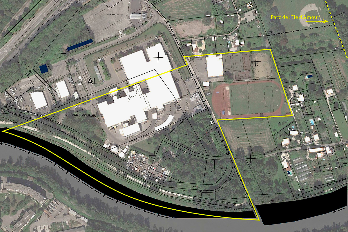
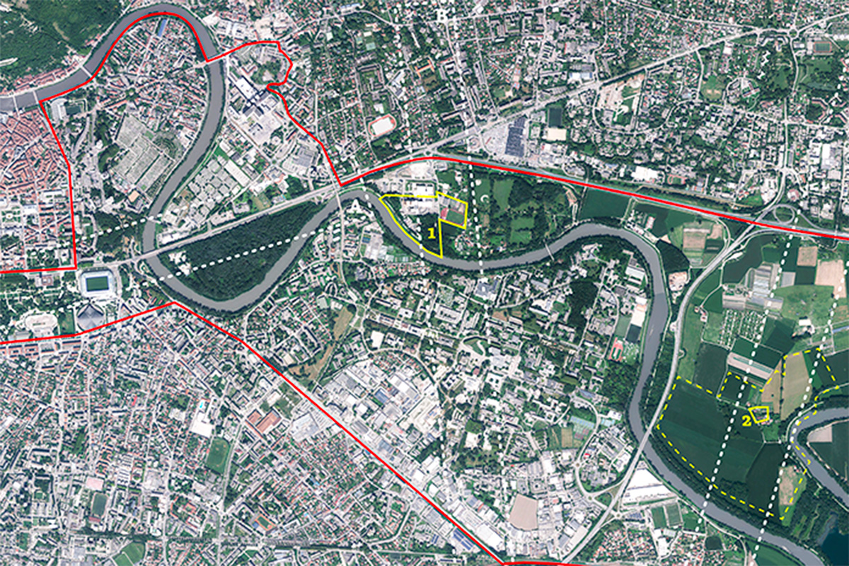
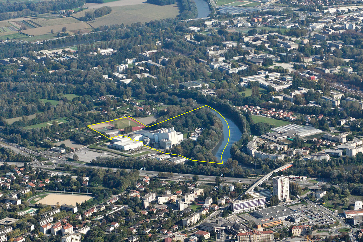
Reflection site 1650 ha - Project site (1) 9,8 ha, (2) 0,7 ha
Site proposed by Grenoble Alpes Métropole
Actors involved City of Grenoble, La Tronche, Meylan, Saint Martin d’Hères, Gières, Domène, Murianette, Grenoble-Alpes Métropole, Departmental Council of Isère, Région Auvergne Rhône-Alpes, Urban Planning Agency of the Grenoble Region, Campus UGA, CHUGA
Owner(s) of the site GAM, municipalities, private owners
Commission after competition Workshop and study and project management missions on one or more mutable sites. Implementations may be initiated with partners.
More Information
Inhabited milieu's challenges
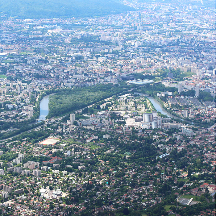
Grenoble-Alpes Métropole is frequently identified by its proximity to the mountain massifs. However, it is the plain that is home to the majority of its inhabitants and their daily lives. Thus, beyond the majestic natural spaces of the Alps, Grenoble Alpes Métropole is seeking to reconnect the urban space and its inhabitants with large natural spaces that are integrated into the city and accessible to all. These natural areas are refuges of bio- diversity, and support leisure, recreational and mobility activities, of course, but they also have agricultural, economic and productive functions, and are linked to the risks of flooding, and it is in all of these aspects that they must be considered and planned.
The Park is partly the result of a distance from the river, as a protective reaction to the risk of flooding. Urban fabrics have developed with their backs to the river and the technical approach to the territory has until now favored a relationship with the river through the prism of technical infrastructures. The theme Living Cities questions this relationship with the natural elements, invites us to explore the diversity of the park’s qualities and to translate the facets of its habitability. The metropolitan technical equipment, the urban park, and the agricultural activities within the park lead us to study it as much from the angle of a produc- tive space as from that of a recreational space. The habitat, sometimes informal, and the movement axes invite us to question the habitability and the mobility. Biodiversity and the presence of water raise questions about the place of the living.
Questions to competitors
A process of arbitration, conception and implementation of projects is expected, which will open and connect the park to its environment, activate synergies and reveal the metabolisms at work in the park, make a project with water and its hazards and enhance the qualities of habitability of the site. It is a matter of defining common and replicable (and not duplicable) rules for the objects, projects and actions that take place there. These projects and actions can be classified according to their typology or the «situations» (spatial, temporal) to which they relate. How do these rules help to reveal the park, make it live and shine?
The process developed by the candidate teams can be applied to the two targeted project sites, but also to other sites identified by the candidates and considered strategic to their proposal.
It will also integrate a phasing, from short to long term and a transcalary work, from micro to macro, imme- diate actions allowing to make the park accessible, to improve its appropriation, to take care of the inter- faces between the projects in progress.
Several themes of the «living city» are prevalent in the Parc of the loops of the Isère and the approach by the «rules of the game» must allow to capture them practically and to translate them into the implementa- tion of a natural, urban and agricultural Park in the grip of current issues.
Questions on the site
Hello, When will we be able to have the plans of the project sites ("geometric surveys") as announced during the site visit?
See dwg in New docs after launch, in the complete site folder, new docs have been uploaded.
is it possible to have a more detailed plan of the buildings on Site 1?
Site 1 plans are currently being finalized and will be available within a few days.
During the visit of the site we were told that we would have received the planimetric drawings of the two sites. Where can we find them?
Site 2 plans have been uploaded to the complete site folder or to New docs after launch, where new files requested after launch are added. Site 1 plans are currently being finalized and will be available within a few days.
During the visit we had not information about the Vaults and Airfield Loop. Neither there are clear objectives specified for those two areas (even if the reflection site comprise them). Is this area supposed to be taken into account for the project? If yes, are there more specific informations for the surroundings areas and the aérodrome?
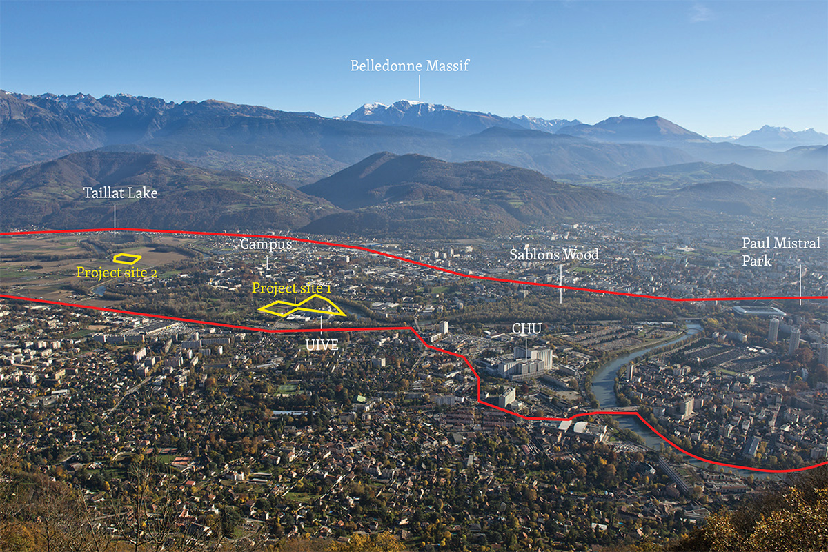
The Voutes and Aérodrome loops are part of the Isère Loops Park and Europan reflection perimeter. Applicants are expected to develop a global strategy for the entire park (red perimeter). Projects (on an urban or architectural scale) are expected on the project sites (yellow), or on any other site included in the red perimeter and deemed strategic by the candidates.
Candidates are free to integrate or not the elements of context or parts of the site of their choice into their strategy and argument.
In addition, like the UIVE, the aerodrome raises the question of how a large-scale facility fits into a park. The vaults, like La Taillat, are an agricultural area. The answers that can be found on the operational sites can therefore perhaps be replicated on these sites.
Is there a possibility to have a history of flooding in the area, as well as the temporality of the flooding? How many times has it flooded in the past years and till what point? How are floods handled at the moment?
There is no shortage of online resources to answer these questions:
Scientific:
https://www.persee.fr/doc/rga_0035-1121_2004_num_92_3_2306
Technical :
popularised :
http://www.irma-grenoble.com/05documentation/04dossiers_numero.php?id_DT=8
official :
https://www.meylan.fr/cms_viewFile.php?idtf=250&path=Liste-des-evenements-PPRI.pdf
https://www.vigicrues.gouv.fr/ftp/plaquettes/plaquette_SPC19.pdf
See New docs after launch in the full site dossier, Carnet de territoire Isère Amont, which contains historical information on water management and the most important floods.
Which water (ground / drinking / river / …) is used to water agricultural fields and does it naturally fertilise the land? Is there drainage / irrigation present?
To water the fields, 4 wells were drilled this year on the 54 ha site. The water is very close and the soil is of very good quality, ideal for market gardening (see the Taillat soil study in the New docs after launch file, in the complete site file). Underground irrigation systems have also been installed at 2 of the market gardeners on the site.
The Taillat agricultural area is located in a meander of the Isère. The land on this plain is made up of alluvial deposits, consisting of materials transported and deposited by watercourses over time through erosion. As a result, the soils in this region are generally composed of silts, sands and gravels. They are rich in organic matter and well drained, making them fertile and suitable for agriculture. Because of their texture and composition, these soils have great agricultural potential. With the exception of periods of heavy rainfall, which can cause the water table to rise, these soils are suitable for growing crops thanks to their filtering nature and the likely presence of capillary action, which helps to provide the necessary water. The land is flat and entirely arable, making it suitable for a variety of crop production, particularly summer crops such as maize and vegetables.
The number of farmers is decreasing in Grenoble (according to statistics) but agriculture is an essential part of the landscape. Are there more agricultural cooperatives or is agriculture increasingly industrialised in the area?
Grenoble has 7 farmers left and not much land. We are seeing the development of urban agriculture on small areas with complementary educational, social and integration activities. We are seeing a change in agriculture in the metropolitan area (49 municipalities), with a reduction in livestock farming and the establishment of small-scale organic market gardening (see the agricultural monograph available in the New docs after launch file, in the complete site folder).
Agriculture in the Grenoble Alpes Métropole area is characterised by a diversity of agricultural production. The majority of farms are small and concentrate mainly on livestock rearing and the production of fruit, vegetables and cereals. The total agricultural area is around 8,000 hectares, representing around 14% of the Metropolitan area. This land is divided between the slopes of the three mountain ranges, which are mainly used for livestock farming, and the plains, where the land is rich in arable crops, market gardening and fodder. Over the last 30 years, the region has lost two-thirds of its farms, in line with the national trend (according to the General Agricultural Census). However, the number of farms has recently stabilised. Today, there are 210 farms in the metropolitan area, employing 225 farmers, nearly two-thirds of whom work as their main occupation, demonstrating the importance of agriculture as an economic activity in its own right.
To what extent is the Isère’s water volume controlled mechanically through dams or pipes?
For one simple reason: the Isère (and some of its tributaries) is a river whose upstream catchment area is used to hold back water (e.g. the Tignes dam and lake). Nevertheless, the flow of the Isère, although influenced by upstream hydroelectric facilities, reacts to rainfall and snowmelt on the scale of its catchment area in the Northern Alps.
What are the rules and regulations from the government regarding usage, building permanent and temporary structures and possible functions of buildings on the flood plain?
Please consult the PLUI and the appendices:
https://www.grenoblealpesmetropole.fr/610-les-documents-du-plui.htm appendices
https://cloud.grenoblealpesmetropole.fr/index.php/s/NK8tLWzTBFgJf4R?path=%2F1D_PPRI
As well as the guide to resilient development (which includes didactic explanations of the regulations and certain specific concepts such as RESi):
https://www.cerema.fr/fr/actualites/amenagement-resilient-zone-inondable-constructible
How are floods handled at the moment? Which water (ground / drinking / river / …) is used to water agricultural fields and does it naturally fertilise the land? Is there drainage / irrigation present?
For more information on flood management, see the following resources:
Scientists :
https://www.persee.fr/doc/rga_0035-1121_2004_num_92_3_2306
Technical :
popularized :
http://www.irma-grenoble.com/05documentation/04dossiers_numero.php?id_DT=8
official :
https://www.meylan.fr/cms_viewFile.php?idtf=250&path=Liste-des-evenements-PPRI.pdf
https://www.vigicrues.gouv.fr/ftp/plaquettes/plaquette_SPC19.pdf
For information on agricultural uses of water, please refer to the responses from the agriculture department.
Contrary to the flooding, does Grenoble face drought issues and water shortages? And if so, is there a trend of trees/forests drying out throughout the years? To what extent is the Isère’s water volume controlled mechanically through dams or pipes?
We are not in an area prone to drought due to the geographical characteristics of Grenoble, with a water table fed by the major Alpine rivers and the presence of nearby hills. We have periods of low water, but no drought on the plains apart from seasonal and potential drops in the water table. This does not prevent us from experiencing more and more periods of drought on our slopes and in our forests, such as in the summer of 2022.
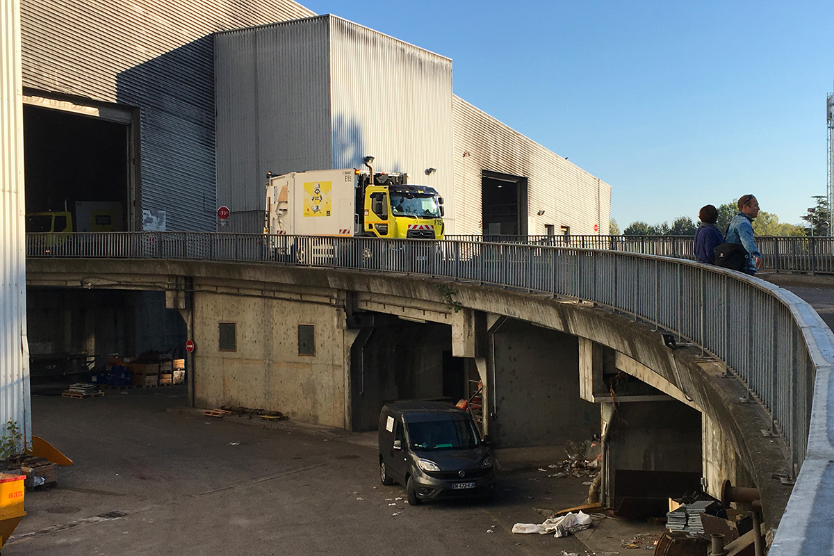
UIVE-ASPTT site Can you specify the timetable for the UIVE demolition/reconstruction project (release of site, duration of demolition, duration of worksite, etc.)?
- Handover of sorting center early 2024
- 2025: deconstruction of the old sorting center (adjacent to the current UIVE) (see step-by-step slideshow) > location of the future new UIVE
- UIVE site base on ASPTT site
- Pro Q4 2024 to Q1 2025
- Q2 2026 Start of UIVE works up to and including Q3 2028
- End 2028 - Start-up of new UIVE then commissioning Q1 2029 UIVE service
- early 2029 to Q3 2030 - Demolition ex UIVE
- Construction of landfill on ASPTT site ?
What is the desired scope of the Maison du Réemploi? Communal, inter-communal or metropolitan? Can you provide a map showing the location of the city's waste/recycling centers (existing and projected)?
The aim is for the centre to cover the whole of the metropolitan area, with the re-use centre complementing the visit to the sorting centre and incinerator for residents of the metropolitan area.
Here's the one for the existing ones: https://www.grenoblealpesmetropole.fr/367-decheteries.htm#panelCarteBis
The current network of landfill sites is available in New docs after launch, file "Evolution_2019-2030_VF", in the complete site fold and on this map the network of recycling centres: http://LES ADRESSES DU RÉEMPLOI DANS LA MÉTROPOLE GRENOBLOISE - uMap (openstreetmap.fr)
Do you have images (perspectives and plans) of the new IUVE project? Can we have plans of the elements to be preserved from the old IUVE?
. The plan of the existing uive, with the location of the pits and the concrete veil, has been filed in New docs after launch, in the complete site file.
The thickness of the concrete veil is not correct. We know that it culminates at 24m. The pits are approximately 12m wide by 35m long (westernmost pit) and 30m long (easternmost pit).
. For the new UIVE, it is not possible to provide plans (not stabilized, ESQ phase).
. Here are the perspectives: https://cloud.grenoblealpesmetropole.fr/index.php/s/gKZaEBGygsrGiRR
Can we have a plan of the planned cycling infrastructure?
=>https://cloud.grenoblealpesmetropole.fr/index.php/s/e2ZKPamrZRcbJcq Here is the map of existing and planned cycle routes
> This is a working document, subject to minor changes until this autumn.
> For the Taillat loop sector: a route is shown along the ring road => the final route will be established following feasibility studies and project decisions.
Are there any plans to reinforce public transport routes (bus, streetcar, train)?
These lines are already adapted to current demand and are well calibrated. There are therefore few changes planned in terms of supply/frequency/route in the 2024/2030 network within the Europan perimeter.
SMMAG is planning to reorganise lines on a wider scale, but within the Europan perimeter, even though some lines may change number, the service and offer will remain the same.
The Chronobus C1 is on the Verdun route and already has a complete exclusive right-of-way in both directions. It should be noted that in view of the challenges of adapting the SMMAG fleet, the C1 will be converted to a trolley bus by 2030 32.
No major changes are planned for Domène or Murianette in terms of public transport (marginal adjustments, but not in any way decisive for Europan).
The main principles for the development of the SMMAG network:
- Move towards a unified network at SMMAG level (Métropole-Grésivaudan in 2024, then Voironnais when they delegate their transport responsibilities to SMMAG) with the creation of SMMAG lines between the 2 areas. Some already exist (C1, 23, G2, 59...)
- Move towards a unified fare system throughout SMMAG: gradual convergence of tag-tougo fares already underway in 2023 (January 2023: creation of a single 5-10 year old ticket for the SMMAG perimeter, unified solidarity fare system from September 2023 (deliberation before the summer), complete unified range of fares targeted in Sept 2024).
- Development of SMMAG suburban links (frequency, legibility, speed, etc.) between the urban core and SMMAG's suburban sectors (Grésivaudan, Grand Sud, Voironnais once they have delegated their transport responsibilities to SMMAG) in conjunction with the regional offer: Ter, Car Région, etc.
- Enhanced urban transport services on the core network (extension of tram D from Etienne Grappe in ST Martin d'Hères to Grenoble (SNCF) station: the line that currently ends at the University (Les Taillées stop) will continue on the B infrastructure through the CHU then the Ile Verte and the centre of Grenoble to the station. Entry into service in September 2024
- renewal of the tramway fleet and extension of the Eybens depot in 2027-32 and a policy of developing cycling for short journeys.
Here are the main principles of the 2024 network study:
- The principle of a suburban service based on strong lines close to urban areas (up to 10/15 km) supplemented by fast (express) lines beyond 10/15 km (= Crolles Brignoud and beyond) with motorway access (existing VRTC on the Voironnais side and planned on the Grésivaudan and Grand Sud sides) with service to multimodal transport hubs at motorway/train station interchanges (Pré de l'Eau, la Batie, Brignoud station, Goncelin, etc.).
- Creation of a fast bypass line between the suburban sector and the outskirts of the urban core: University/Grand Place.
- Little change in terms of spatial planning apart from the PEMs and the VRTC project supported by the State
o The new line takes over sections of the existing line and is based on the motorway
o Merging/grouping together certain lines to optimise resources and provide a clearer offer
o Increase frequencies/amplitude, modify the routes of suburban lines
In addition, we would like to provide you with information on the mobility challenges facing the North-East Polarity:
- Capacity (of avenue de verdun?) 5650 vhl/H VS HPS demand (evening rush hour): 7500 VH/H
- An accessibility bottleneck at the Isère Saint Martin d'Hères screen
- Concentration of all modes of transport at the entrance to Grenoble, which is intensifying as the population increases
- Reduced capacity for all modes of transport at the Isère crossings and at the entrance to the city centre.
- In order to improve multimodal accessibility, long-term ambitions are envisaged for the sector, which will nevertheless have an impact on road capacity on the screen
- Projected road capacity on the screen is lower than at present
- With no change in modal practices, projected car demand on the screen will increase compared with the current situation
Road capacity on the screen is no longer sufficient to meet demand - an estimated shortfall of 1,850 veh / or 25% of current demand
What potential do these users have for alternative modes of transport developed in parallel? How can these transfers be optimised?
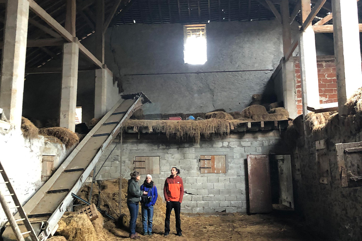
Can you provide information on the winners of the Metropolitan Farm AMI (type of crop, surface area allocated, production target, infrastructure requirements)?
Documents providing environmental data for the Taillat sector are available in New docs after launch, in the complete site folder.
Can we have a survey of all the farm buildings?
The elements have been transmitted, otherwise see in the New docs after launch in the complete site folder, new documents have been submitted.
Is there an impact study or environmental analysis of the site? And/or a flora-fauna survey?
At the scale of the large site no, but we have and have transmitted (in the complete site file or New docs after launch) :
- Environmental study athanor site
- Parc de l'ile d'amour management plan
- Taillat: See in New docs after launch in the complete site folder, 2 new files have been uploaded
FR-GAM-SS-T03 Tertiary and technology campuses.pdf : Can you give us details of the acronyms shown on this map?
- CSTB: Centre Scientifique et Technique du Bâtiment (Scientific and Technical Building Centre)
- GEA : SYSTEMES DE PEAGE GRENOBLOISE D'ELECTRONIQUE ET D'AUTOMATISMES located in Meylan, France
- IMAB > obviously wrong: IMAG - https://batiment.imag.fr/
The IMAG building's strategy is to concentrate resources and skills to create a critical mass (800 teacher-researchers, researchers and doctoral students), increase synergies and guarantee Grenoble's worldwide visibility. The research activity within this building will also enable the cooperation between local players, already taking place within Grenoble's Carnot Institute for "software and intelligent systems" and the Minalogic competitiveness cluster, to be greatly amplified and reach the stage of integrative research.
The building houses the following laboratories and departments in alphabetical order: Agence pour les Mathématiques en Interaction avec les Entreprises et la Société (AMIES), Grenoble Alpes Recherche Infrastructure de CAlcul Intensif et de Données (GRICAD), Laboratoire d'Informatique de Grenoble (LIG), Laboratoire Jean Kuntzmann (LJK), VERIMAG.
An innovation gas pedal able to facilitate the transfer of laboratory research to industry. Fundamental research and applied research do not conflict, but complement each other.
- SMH = Saint Martin d'Hères
- PM = Multimodal hub
- FSC ?
- IAB: Institute for the Advancement of Biosciences (CHU)
- ARTEPARC: A 3RD GENERATION BUSINESS PARK 15 MINUTES FROM THE HEART OF THE INOVALLÉE TECHNOLOGY PARK AND GRENOBLE CITY CENTER
6 BUILDINGS -848 PARKING SPACES - A SERVICE CENTER - https://www.groupe-artea.fr/reference/arteparc-meylan/
- INRIA: research center (Data science; Environmental modeling; Technical, environmental and ethical reliability of software; Quantum computing)
- https://www.inria.fr/fr/centre-inria-universite-grenoble-alpes
- TARMARC: Tarmac is the technology startup incubator created by inovallée in 2014 https://tarmac.inovallee.com/
Can you tell us more about the technical services to be set up in the former ASPTT premises?
Temporary use (for at least 7/8 years) as a green spaces technical center for the town of La Tronche.
You can take into account the surface area of the current gymnasium (800 m²), as it is this building that is being rehabilitated. The surfaces and geometries are included in the New docs after launch folder, file "Evolution_2019-2030_VF", in the complete site folder.
For the programme for the La Tronche CTM project, see files "2480 - NOTE PROGRAMMATIQUE GYMNASE ASPTT - Annexe" and "2480 - NOTE PROGRAMMATIQUE GYMNASE ASPTT et surfaces", in NEW DOCS AFTER LAUNCH, in the complete site folder.
This site is connected to the following theme
LET THE BIRDS SING! Imagine public space as a biodiverse landscape. Imagine public space as the touching ground, the proof that YES, WE CAN –through design– address challenges caused by the crisis due to climate change, in terms of social and environmental issues. Imagine public space as the agent for inclusion of difference both in terms of humans and non-humans, as a mediator between new interdependencies. Imagine soils, water bodies, shores and eco-corridors as the main actors to guide complex transformation processes. On the following sites, public space is seen as the area where the topic of Living Cities is performed.
Reimagining public space as a biodiverse landscape
Questions on the site
You have to be connected –and therefore registered– to be able to ask a question.
Fr. 16 May 2025
Deadline for submitting questions
Fr. 30 May 2025
Deadline for answers
Before submitting a question, make sure it does not already appear in the FAQ.
Please ask questions on sites in the Sites section.
Please ask questions on rules in the Rules section.
If your question does not receive any answer in 10 days, check the FAQ to make sure the answer does not appear under another label or email the secretariat concerned by the question (national secretariat for the sites, European secretariat for the rules).