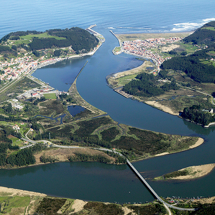
Nalón Estuary (ES)
The Synthetic Site Folder and Site Brief are available for free.
Please register and login to access the Complete Site Folder.
- Synthetic site folder EN | ES
- Site Brief EN | ES
- Site on Google Maps
- Back to map
Data
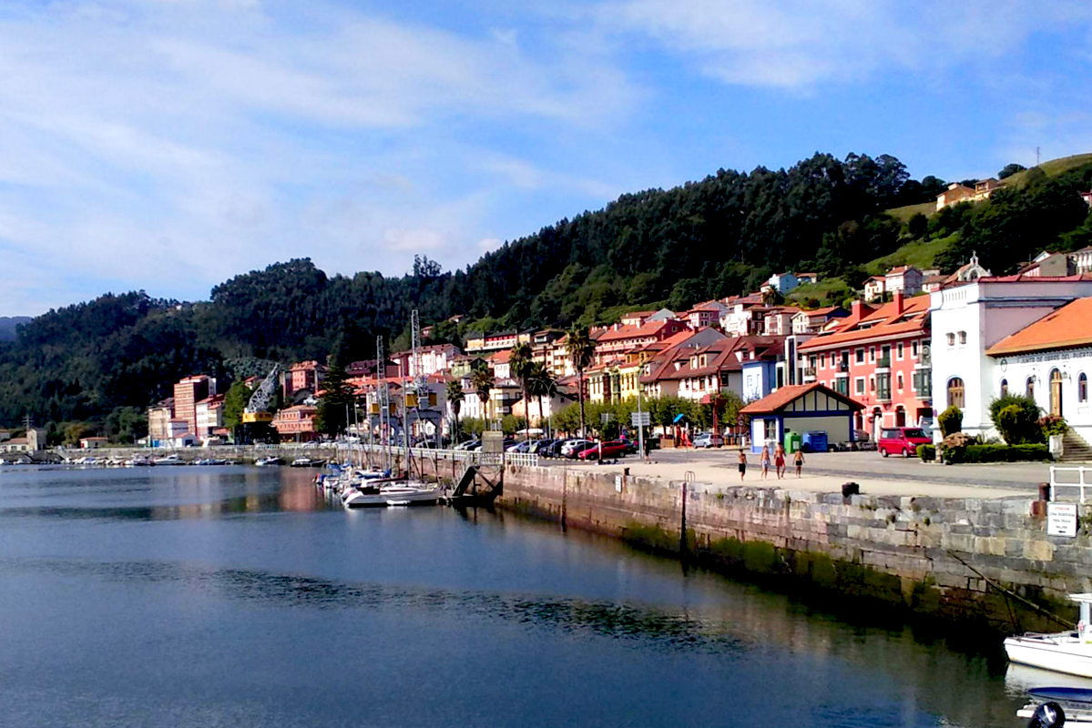
NALÓN ESTUARY (ES)
Scales XL/S
Team representative Architect/landscape designer
Location San Esteban (Muros de Nalón) and L’Arena (Soto del Barco), Principality of Asturias
Population Territorial area 6,243 inhabitants Reflection area 1,845 inhabitants
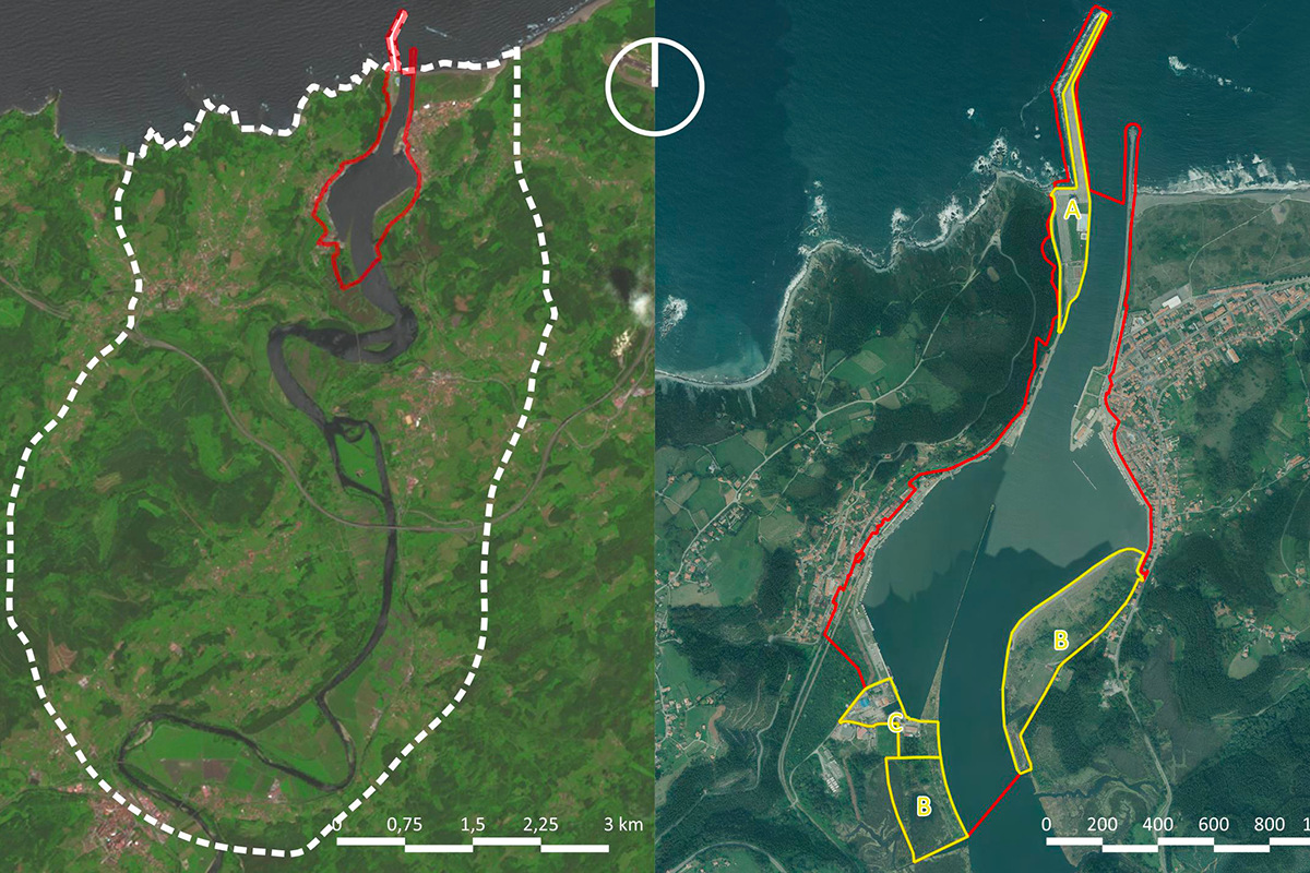
Reflection site 135.82 ha
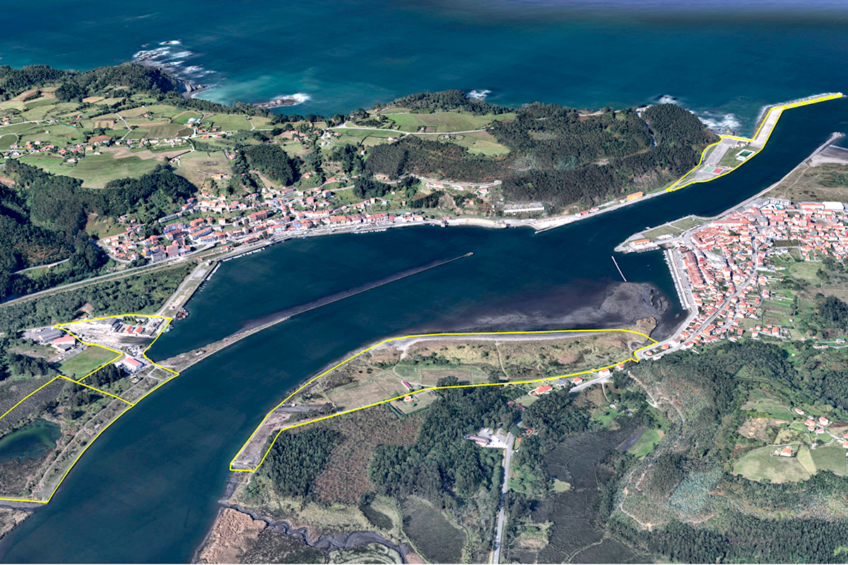
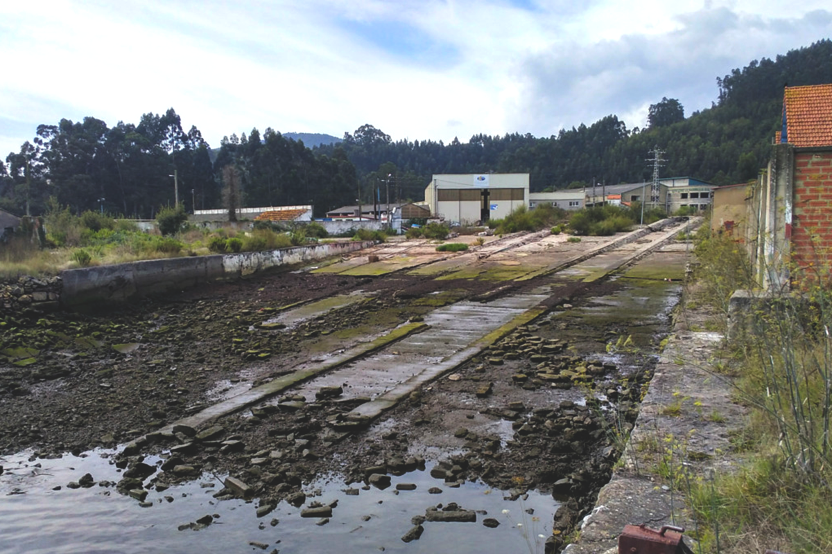
Project site Site A: Dike and esplanade of Puerto Chico: 6.39 ha. / Site B: Junquera and la Paloma beach: 21.0 ha. / Site C: Former shipyard of La Junquera: 4.35 ha
Site proposed by Regional Ministry of Rural Affairs and Territorial Cohesion of the Principality of Asturias
Actors involved Soto del Barco and Muros de Nalón City Councils
Owner(s) of the site Public
Commission after competition Site A: Project for the renaturation of the dyke and esplanade of Puerto Chi- co and management of the works/ Site B: Project for the environmental recovery of the beach of La Paloma and La Junquera; management of the works/ Site C: Drafting of an urban development plan for the surroundings of the old shipyard.
More Information
Inhabited milieu's challenges
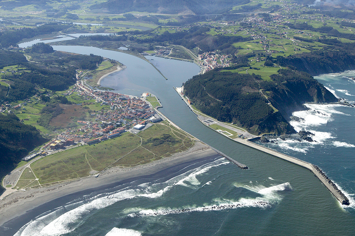
The Nalón estuary is a complex and unique territorial system, which combines high environmental, landscape and cultural values, and which faces significant ecological, climatic and economic diversification challenges as an alternative to the decline of port and fishing activity. According to the Europan 17 theme, the three sites of the Nalón Estuary encompass such interrelated natural and cultural dimensions that the whole study area can be understood as an ecotone, that is, a transitional space between rural, urban and natural landscapes: 1- It stands out for its environmental and ecological values, which is why it is included in a Special Protection Area for Birds, a Site of Community Im- portance and a Special Area of Conservation within the Natura 2000 Network. 2- One hundred years of intense port activity have resulted in a valuable industrial heritage, including a shipyard, docks, loading bays and other infrastructure, as well as welded steel-framed cranes and railway equipment. 3- Although its role as a modal transport interchanger has diminished significantly, the port itself is an ecotone between the marine and terrestrial environments.
On the other hand, the lower course of the river Nalón presents a high level of flood risk, which will increase due to the foreseeable impacts of climate change. It should also be considered that the area is located on the western boundary of the Central Metropolitan Area of Asturias, a multi-polar urban conurbation with 850,000 inhabitants and 85% of the regional GDP. It is therefore destined to become a key element in the metropolitan system of open spaces.
All the land is publicly owned and all the public actors concerned are involved in the proposal: at the regional level, the departments of Infrastructures, Fishing, Biodiversity and Territorial Planning; and at the local level, Muros de Nalón and Soto del Barco City Councils.
Questions to the competitors
The port infrastructure of the Nalón Estuary was designed and dimensioned at the beginning of the 20th century as the main embarkation and transport point for all the coal production from the Astu- rian mines to the steel plants in the Basque Country; it is therefore part of the collective imaginary and collective identity of the region. The decline of mining brought with it the gradual abandonment of the activity, so it is necessary to reinvent the port area to accommodate new activities, to: 1. Renaturalise and contribute to the adaptation to climate change in the whole the estuary, 2. Preserve and consider the valuable local industrial heritage, and 3. Foster the production of ecosystem-based supply, regulation and cultural services.
Matters to be considered by the applicants:
• Adaptation to climate change. The estuary suffers from significant river flooding, which particularly affects the agricultural sector. According to climate projections available for the region, the average sea level will rise significantly and extreme weather events will become more intense and frequent, thus increasing the risk of flooding.
• Ecosystem improvement. After decades of industrial activity, mainly focused on coal port traffic, several restoration projects have significantly improved the environmental conditions of the estuary; however, much remains to be done to regenerate the diverse and valuable ecosystems, including beaches, marshes and swamps.
• Cohabitation between economic and environmental transitions. The environmental and landscape quality is an appeal for new recreational activities typical of coastal areas; therefore the challenge that the estuary faces is to compatibilise the protection of biodiversity, the production of ecosystem services and economic diversification.
Questions on the site
Hello! We believe that most files in .dxf format are defective. They do not contain the information that would correspond to the files in .pdf format. Also the file named "ES-ESTUARIO_DEL_NALON-SS-M11_1995.pdf" is blank. And "PS-f_maps-characteristic-elements" folder is empty. Thanks
Thank you for the warning. All "Maps" files have been replaced. Please excuse us.
In the site report, the L'Arena dock is included as part of site C, however, the boundaries of this site are not represented on the general maps or Google Maps.
The Google maps error has been solved. Thank you.
Somos un equipo de fuera de Asturias que porque por motivos laborales no podemos acudir a la visita del día 1. ¿Sería posible hacer la visita del lugar entre el 3-5 junio? o en tal caso, revisando la información del europan, ¿sería posible hacerla online? Muchas gracias.
No será posible repetir la visita: Sin embargo, al tratarse de espacios abiertos, pueden recorrer el lugar con total libertad. No obstante, la visita será grabada y publicada en la Web.
Nos acabáis de decir que la visita será grabada y publicada en la web, ¿Se sabe cuando la vais a publicar? Sería muy útil poder verla antes de visitar el lugar. Gracias
Tras grabar la visita hay que editar el vídeo y subtitularlo-. No sabemos cuando estará preparado
EN EL APARTADO TERRIRORY, EL CAD ES-ESTUARIO_DEL_NALON-C-M2 NO TIENE LA LEYENDA EN SUS CAPAS, TIENE NUMEROS. LA LEYENDA QUE APARECE EN EL PDF NO INCLUYE LAS CAPAS 232 Y 240 DEL CAD. BASADO EN LA CANTIDAD DE HATCHES EN EL PLANO, 232 PARECE UNA CAPA FUNDAMENTAL PARA EL PLANO, POR LO TANTO ES NECESARIO TENER SU CORRESPONDIENTE TITULO.
Se ha sustituido el archivo. Nuestras disculpas
Corrected, apologies for the mistake.
Nalon Estuary visit
The visit to the Nalón Estuary site on June 1st will start at 10:00 (see meeting point here), and the expected duration is 4 hours. It will consist in a guided tour along the three project sites on both riversides. Detailed explanations will be provided by the general director for Urban and Spatial Planning in the Principality of Asturias, architect and urban planner Sonia Puente Landázuri. She will also be happy to answer any questions or remarks raised by the participants. We look forward to meeting you all next June 1st!
Hello, we believe that "ES-ESTUARIO_DEL_NALON-C-M3.dxf" does not have the information shown in the corresponding pdf "ES-ESTUARIO_DEL_NALON-C-M3.pdf". Could you update it, please?
ES-ESTUARIO_DEL_NALON-C-M3.pdf was created in a GIS application and shows the flood risk at the Estuary for a return period of 500 years. The original format for this information is a raster image, provided by the Spanish Ministry for the Ecological Transition and the Demographic Challenge. Since a raster image is composed by a matrix of square pixels, it can not be converted into a CAD vector layer. Anyway, it can be easily accessed via this WMS https://servicios.idee.es/wms-inspire/riesgos-naturales/inundaciones. But if you are not familiar with GIS procedures, we add to the complete site folder (new docs after launch) a .png georreferenced image we hope you can easily insert into your .dxf.
If the proposal includes the removal and/or rearrangement of any building or structure that currently serves public purposes, should they be relocated within the reflexion or project site be determined? (For example: sports areas, waste management areas, industrial uses, docks...)
The project sites include a wide array of buildings and infrastructures, that's why it would be difficult to provide an answer to the question posed that encompasses every situation. As a principle, and in broad terms, removal or rearrangement of existing assets is encouraged, especially for sites A and C, and a rationale for the changes proposed is expected. In site C, the waste management area should definitely be relocated. Docks and other port infrastructures can be modified, under the condition that port operability is not lessened, and new activities related to the Blue Economy are supported. Sports and leisure areas can be relocated, but the removal of the saltwater pool in site A would require a detailed justification.
Buenas tardes, podrían colgar las líneas de cota de marea alta y baja en formato editable (dwg) y la topografia de la cota negativas, bajo la cota 0, tanto del río como de la costa?
Se han subido al Complete site folder / New documents after launc
¿(San Juan de la Arena) Se puede desviar parte del trafico de calle Bajamar y calle de la Galerna fuera del area de proyecto (proponiendo una alternativa)?
Sí, es posible plantear la peatonalización de esas calles, siempre que se garantice el acceso rodado a viviendas, equipamientos y locales de negocio, y se proponga una alternativa a la movilidad en vehículo privado actual, aun fuera del área de proyecto.
Dentro del puerto de San Juan de la Arena existen actualmente dos rampas de acceso al agua para los barcos. ¿Es necesario mantener las dos rampas o se puede reducir el area de acceso?
Ambas rampas deben mantenerse, puesto que están en uso y permiten separar usuarios dentro de la zona portuaria.
En el rediseño del parque de San Juan se pide un espacio de eventos. ¿Para cuántas personas?
Es difícil de cuantificar. El aforo sería el propio de eventos tales como ferias, mercados, festivales, fiestas patronales y similares, de ámbito local y en ocasiones, de alcance comarcal.
¿Vamos a tener acceso al video del drone que se mostró en la presentación de Europan España en Madrid?
See the presentation trough https://youtu.be/h8BuGcQDMEM minute 58. Translation is in progress
¿Se busca tener una ampliación del puerto de San Juan para uso turistico?
Más que la ampliación de las actuales instalaciones, con el concurso se pretende explorar fórmulas y procesos para la reutilización de las existentes albergando usos diversos, relacionados con la Economía Azul, como la logística, la pesca sostenible, el turismo costero, o los deportes náuticos.
El archivo de autocad tiene capas de batimetria pero no tienen lineas. Sería posible recibir esta información?
See "New documents after launch"
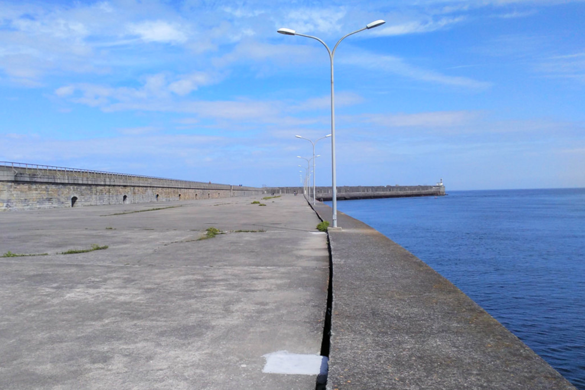
Who are the users of the San Esteban breakwater car park? Cuales son los usuarios del aparcamiento del espigón de San Esteban?
Throughout the year, anglers and occasional walkers; at weekends, in addition, customers of the restaurant; and in summer, users of La Guardada beach and the swimming pool.
Durante todo el año, pescadores de caña y paseantes ocasionales; los fines de semana, además, clientes del restaurante; y en verano, usuarios de la playa de La Guardada y de la piscina.
Is the big ramp of the Xunquera active or is it kept as a historical legacy? La gran rampa de la Xunquera esta activa o se mantiene como un legado historico?
The Ports and Transport Infrastructure Service of the Principality of Asturias informs that the ramp of the former La Parrilla shipyard is not currently in use.
El Servicio de Puertos e Infraestructuras del Transporte del Principado de Asturias informa que la rampa de los antiguos astilleros La Parrilla no se encuentra actualmente en uso.
Is it allowed to create a new bridge to connect both embankments? ¿Es posible crear un nuevo puente que conecte las dos orillas?
As stated in the site brief, the global challenge for participants is to design methodologies and processes to revitalize an existing port infrastructure, taking into account the rich natural and cultural heritage in the estuary. In terms of the present competition, and according with this edition’s theme, based upon the concept of “care” as applied to urban planning, entries should be focused on the optimisation and resilience of existing infrastructures, in the framework of the sustainability and the balance of its three dimensions, rather than on creating new ones. Besides, during the participation process, no shared concern about the issue was raised. In addition, a seasonal boat service “La Carmela” and a road bridge southwards are already available to connect both shores; it is planned by the Regional Government of Asturias to complete the present Coastal Path along the Cantabrian Sea in this sector, on the basis of the existing road and pedestrian networks.
Tal como se indica en el pliego, el reto global planteado a los participantes es diseñar metodologías y procesos para revitalizar la actual infraestructura portuaria, teniendo en cuenta la riqueza del patrimonio cultural y natural del estuario. Por lo que se refiere al concurso, y de acuerdo con el tema de esta edición, basado en el concepto de "cuidado" aplicado al planeamiento urbano, las propuestas deberán centrarse en la optimización y la resiliencia de las infraestructuras existentes, en el marco de la sostenibilidad y el equilibrio entre sus tres componentes, más que en la creación de otras nuevas. Además, durante el proceso de participación ciudadana no se suscitó una preocupación compartida sobre esta cuestión. Por otra parte, la conexión entre ambas orillas está resuelta mediante un servicio estival prestado por la embarcación "La Carmela" y el puente sobre el río Nalón situado más al sur. El Gobierno del Principado de Asturias tiene previsto completar la actual Senda Litoral al borde del Cantábrico en este ámbito, sobre la base de la red viaria y peatonal existente.
Is it possible to change the materiality of the breakwater and replace the hard concrete pavement with other materials closer to the nature of the site?
¿Es posible cambiar la materialidad del dique y reemplazar el pavimento duro de hormigón por otros materiales más próximos a la propia naturaleza del lugar?
Yes, it is possible to act on the current pavement of the dock to favour new uses compatible with port activity and to contribute to the renaturalisation of the mouth.
Si, es posible actuar sobre el pavimento actual del dique para favorecer nuevos usos compatibles con la actividad portuaria y contribuir a la renaturalización de la desembocadura.
This site is connected to the following theme
LET THE BIRDS SING! Imagine public space as a biodiverse landscape. Imagine public space as the touching ground, the proof that YES, WE CAN –through design– address challenges caused by the crisis due to climate change, in terms of social and environmental issues. Imagine public space as the agent for inclusion of difference both in terms of humans and non-humans, as a mediator between new interdependencies. Imagine soils, water bodies, shores and eco-corridors as the main actors to guide complex transformation processes. On the following sites, public space is seen as the area where the topic of Living Cities is performed.
Reimagining public space as a biodiverse landscape
Specific documents
Questions on the site
You have to be connected –and therefore registered– to be able to ask a question.
Fr. 16 May 2025
Deadline for submitting questions
Fr. 30 May 2025
Deadline for answers
Before submitting a question, make sure it does not already appear in the FAQ.
Please ask questions on sites in the Sites section.
Please ask questions on rules in the Rules section.
If your question does not receive any answer in 10 days, check the FAQ to make sure the answer does not appear under another label or email the secretariat concerned by the question (national secretariat for the sites, European secretariat for the rules).