Barcelona-La Font del Gos (ES)
The Synthetic Site Folder and Site Brief are available for free.
Please register and login to access the Complete Site Folder.
- Synthetic site folder EN | ES
- Site Brief EN | ES
- Site on Google Maps
- Back to map
Data
BARCELONA-LA FONT DEL GOS (ES)
Scales L/S
Team composition Architect mandatory
Location Barcelona, Spain
Population 350 inhabitants
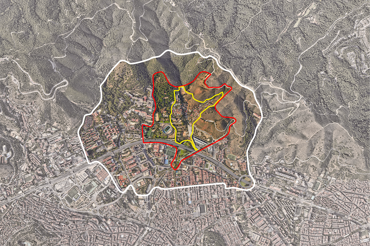
Reflection site 69,3 ha - Project site 17,6 ha
Site proposed by Barcelona City Council
Actors involved Barcelona City Council, private parties
Owner(s) of the site Barcelona City Council, private parties
Commission after competition Development of an urban planning master plan that must outline the necessary planning instruments, which will be agreed upon with the Management Office for Urban Planning for subsequent processing.
More Information
SITE / CONTEXT
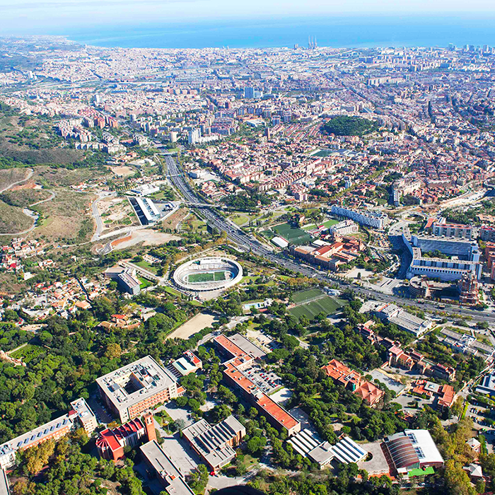
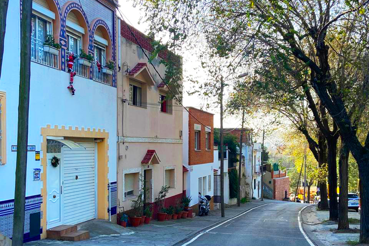
La Font del Gos is a residential area located in the district of Horta-Guinardó, in northwest Barcelona and at the foot of the Collserola mountain range.
The neighbourhood emerged in the 1930s, due to immigration from other parts of Spain (which created a demand for new housing), resulting in settlements that were established in rural areas without prior planning.
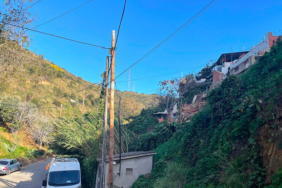
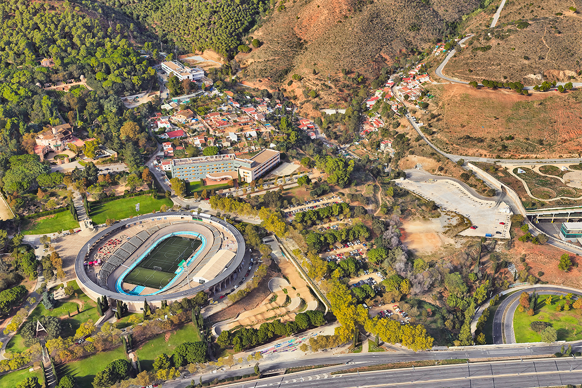
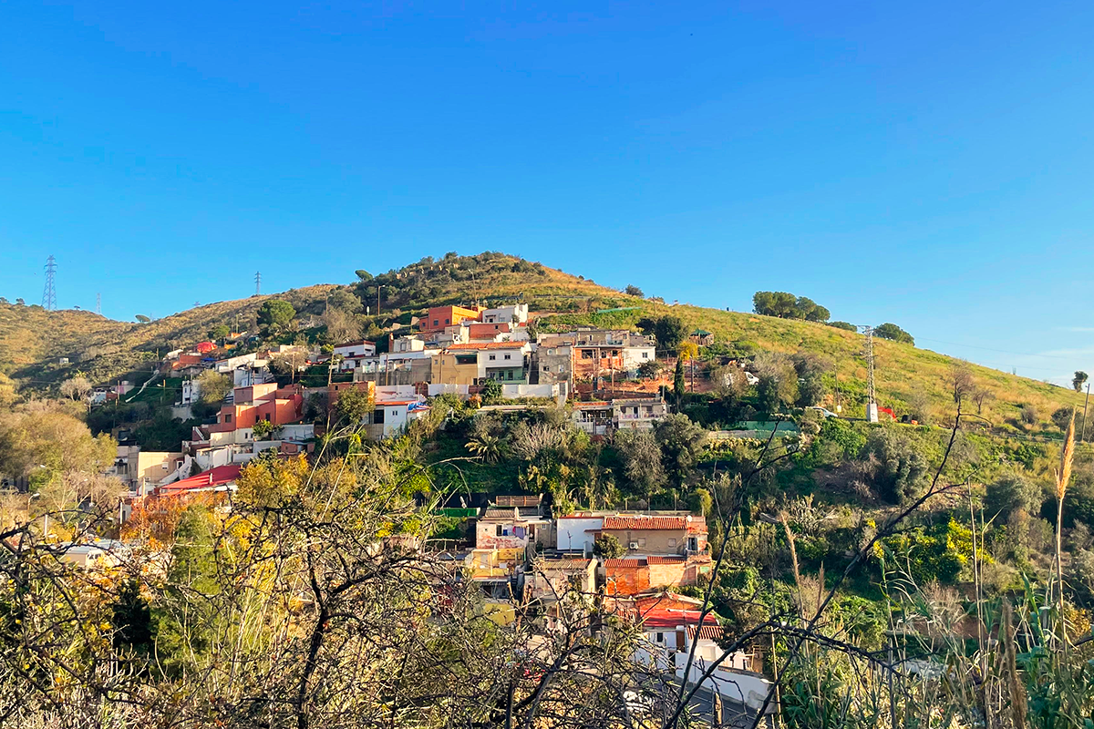
La Font del Gos has never been officially recognised as a neighbourhood, a perception influenced by several factors, including the construction of the Ronda de Dalt, a major road that created a physical barrier between the La Font del Gos area and the rest of the city, in preparation for the 1992 Olympics. Around the same time and in following years as well, the construction of other large-scale facilities, such as the Velodrome, furthered the divide between this residential area and the rest of the city. The urban area is located on the steep topography that is typical of the area, and consists of two main streets that follow the watercourse, forming the two primary settlements: Cal Notari and La Font del Gos.
Comprising approximately 100 homes and 350 residents, the area has long been affected by the Metropolitan General Plan and other urban planning schemes, which have hindered its proper development and maintenance.
The most relevant of these affectations is related to the Cal Notari area, classified as a protected area of the Collserola Natural Park. In this area, the houses are located in a non-buildable area and must be relocated, or exceptionally, being part of a system and a typology, which allows its location within the Natural Park.
There is also a lack of services such as basic shops and neighbourhood facilities, forcing residents to travel to other areas of the city despite the challenges posed by limited access and insufficient public transport.
It is a part of the city that straddles urban and natural environments, which is why the site offers opportunities beyond the urban level, forming part of a larger ecosystem, with the potential to act as a catalyst for initiatives related to the climate emergency and other crucial factors for modern cities.
QUESTIONS TO COMPETITORS
First and foremost, we believe the project for this area should take a global and local approach, focusing on the development model that should be applied in spaces at the boundary between the city and nature. This is a “peri-urban” context, where different areas at the city’s edges converge. At this local level, it is important to consider the form and function of these spaces within the larger ecosystem that surrounds them.
Secondly, attention should be given to the connection with the city and its metropolitan function. What role can La Font del Gos play within the city and what interdependent relationships can be created to reinforce its metropolitan connection? How can the connections with its urban surroundings be improved to facilitate these relationships? And with its natural surroundings?
Finally, as a local consideration, we invite participants to consider what type of urban networks, residential dwellings, and local uses should define this area to help maintain its own identity and way of functioning while also serving as a boundary and a transitional space. What are the characteristics of this boundary? How is it defined? What are the redevelopment possibilities? What about the renaturalisation possibilities?
Lastly, it will be necessary to analyse the best way to implement this new plan, defining work for the short, medium, and long term to ensure its viability and sustainability.
Questions on the site
Hi, I can't see any mention in the project brief about a site visit. Is there an official date scheduled for a site visit? Thanks.
The visit will take place 7th May. Practical information will be publisehd on the Europen web.
Can the pre-existing buildings be "deleted" from the intervention area and start from scracth?
Project proposals must take into account the degree of the affected areas by the urban planning as well as the state of conservation of the existing houses, as many of them are in good condition. On this basis, participants should make a decision in line with current social and environmental requirements. For our part, any well-justified proposal that demonstrates feasibility will be welcomed in the evaluation process. Best regards,
Is an organized site visit planned for the La Font del Gos site?
The visit will take place on 7 May. We will inform about the time and meeting point.
From the brief we understand that there is a need of new residential building to increase density, but the general topic of competiton is re-new re-source, is it possible to add new residential building to cover this need enlight in the brief of Font del Gos ?
The competition requires guaranteeing housing for current residents of Font del Gos. At the same time, it invites a rethinking of the neighborhood’s role within the broader context of Barcelona. In light of this, while there is no set target for increasing density, proposals may consider it if supported by solid analysis and clear justification. Referencing similar urban contexts in Barcelona is encouraged when assessing feasibility and formulating proposals. The addition of new housing is possible, as long as it aligns with the competition’s vision: re-new, re-source. We hope this helps, otherwise don’t hesitate to contact again. Thank you again. We are looking forward to see your proposals!
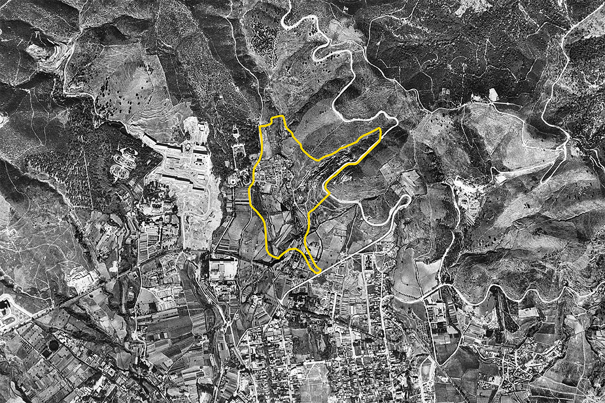
North of Centre Educatiu Can Llupià, there is a rectangular plot that appears ambiguously defined—looking like a field in aerial images, but its use is unclear. Could you clarify its current or intended function, and if there are any planned developments or restrictions?
Thank you for contacting us, we are glad to help you! The plot you mention used to be a football field. It is currently out of use and inscribed in a protection area defined in the city's urban plan (Collserola Forest Park). However this does not exclude the possibility of a project-related intervention, as long as it is properly justified. We hope this clarifies your questions, otherwise don’t hesitate to contact us again. Thank you again, we are looking forward to see your proposals!
From the brief we understand that there is a need of new residential buildings to increase density, how many new residents are expected to live in the Font del Gos Barrio?
The competition requires guaranteeing housing for current residents of Font del Gos. At the same time, it invites a rethinking of the neighbourhood’s role within the broader context of Barcelona. In light of this, while there is no set target for increasing density, proposals may consider it if supported by solid analysis and clear justification. Referencing similar urban contexts in Barcelona is encouraged when assessing feasibility and formulating proposals. We hope this helps, otherwise don’t hesitate to contact again.
The 2015 agreement mentioned covering or modifying the Ronda de Dalt in northern Horta-Guinardó. Could you confirm if this project is still planned or scheduled? Should participants design for the current state or anticipate future coverage when working on La Font del Gos?
La Ronda de Dalt is an urban barrier that should be taken into consideration. Its covering project is an approved urban infrastructure project and it is part of the city's long-term planning agenda. However, participants can explore alternative design strategies related to the Ronda de Dalt, as long as it is properly justified. It is important to clarify that the Ronda de Dalt is included within the City Scale analysis area but not within the Project Site. This means it should be considered as part of the broader urban context to be addressed, but not as the primary focus of the intervention. For further information, we attach a link documenting the Ronda de Dalt coverage proposal: https://avsantgenis.wordpress.com/wp-content/uploads/2016/05/proposta-bec-rondadalt-20160510.pdf
Are you going to upload a summary of the site visit similar to other sites? Is it possible to have a report of it? Are there any videos and photos from that day? Was there any major issue addressed during the site visit and what was the discussion around it?
It will be publisehd very soon.
Is it possible to have a 3D model of the area?
You will find a 3D model of any part of the city in this website as well as many other plans and digital models in the following link: https://geoportalcartografia.amb.cat/AppGeoportalCartografia2/index.html
Could you please upload information about drought, floodings and fires that happened lately in the area of interest of close to it? For example a map showing the areas that are most prone to natural disasters.
You will find information regarding the flood risk and other hydraulic data in the following link: https://sig.gencat.cat/visors/VISOR_ACA.html
And the following website shows the Civil Protection Map of Catalonia where you can find the fire risk map and other natural risks maps: https://pcivil.icgc.cat/pcivil/v2/index.html#41.40931,2.12897,6z.
We hope this can be of help to you. Best regards
Do you have any more precise demographic data on Font de Gos and the Cal Notari neighborhoods/area? Except from those on the brief which refer to the whole Horta neighborhood that extends under the highway.
Unfortunately, we don't have any more detailed information about the population of La Font del Gos than what is already published. However, we have included the contact details for the Horta-Guinardó public administration office, in case they are able to provide you with this information.
La Font del Gos also has its own website, where you can find more details about its residents. There is also a book in which the author aims to give visibility to the neighbourhood and which contains a lot of interesting information.
Horta-Guinardó district website: http://barcelona.cat/tramits
The phone number for the Horta-Guinardó district is 931537010.
Font del Gos website: https://fontdelgos.webnode.es/
Font del Gos book: https://adg-fad.org/laus/proyecto/font-del-gos-un-barrio-olvidado-de-barcelona-0/.
We hope this information is helpful to you. Best regards,
Could you please give us more information about the current state and the usage of the parking lot next to the Velodrome, the open parking lot next to the only bus stop in the area, and lastly about the Parc de Xavier Montsalvatge? This last one seems still under construction or abandoned to us through the Google maps imagery.
The car park next to the Velodrome is mainly used by students and people who use the public facilities in the area, such as universities and sports centres. It might be interesting to rethink the use of these parking areas.
Please find our questions regarding the site: 1. On the map, three lines in different colors (white, red, and yellow) are shown. What is the significance of each line, and how do the areas they outline differ? (eg the strategic masterplan should be considered in the white boundary?) 2. Are there any documents available from the site visit—such as photos, information, or presentation materials—that we could access? 3.Is there a recommended or preferred percentage of buildings that may be considered for demolition?
Could you please give us more information about the current state and the usage of the parking lot next to the Velodrome, the open parking lot next to the only bus stop in the area, and lastly about the Parc de Xavier Montsalvatge? This last one seems still under construction or abandoned to us through the Google maps imagery.
The Xavier Montsalvatge Park is complete. However, due to its location, it has very little use. This is an important issue within the study area, given that the park is in a privileged location and could contribute positively to the city.
This site is connected to the following theme
Re-sourcing from natural elements How to design processes and projects for the revaluation of landscapes that focus on the interdependencies and eco-dependencies of resources (natural, cultural, productive) and the territory? The regeneration of landscapes can become a mediation tool between residential areas, facilities, and obsolete infrastructures and territories undergoing transformation (even at risk) as a result of the effects of climate change. Is an invitation to think at the resources of the area in a regenerative way to support a healthier environment for humans and non-humans?
Regenerating Landscapes
Specific documents
Questions on the site
You have to be connected –and therefore registered– to be able to ask a question.
Fr. 16 May 2025
Deadline for submitting questions
Fr. 30 May 2025
Deadline for answers
Before submitting a question, make sure it does not already appear in the FAQ.
Please ask questions on sites in the Sites section.
Please ask questions on rules in the Rules section.
If your question does not receive any answer in 10 days, check the FAQ to make sure the answer does not appear under another label or email the secretariat concerned by the question (national secretariat for the sites, European secretariat for the rules).