Grand Nancy (FR)
The Synthetic Site Folder and Site Brief are available for free.
Please register and login to access the Complete Site Folder.
- Synthetic site folder EN | FR
- Site Brief EN | FR
- Site on Google Maps
- Back to map
Data
Grand Nancy (FR)
Scales XL/L
Team composition Architect mandatory
Location Nancy, Jarville-la-Malgrange (54)
Population Metropolitan area 250,000 inhabitants - Nancy 105,000 inhabitants - Jarville 9,400 inhabitants
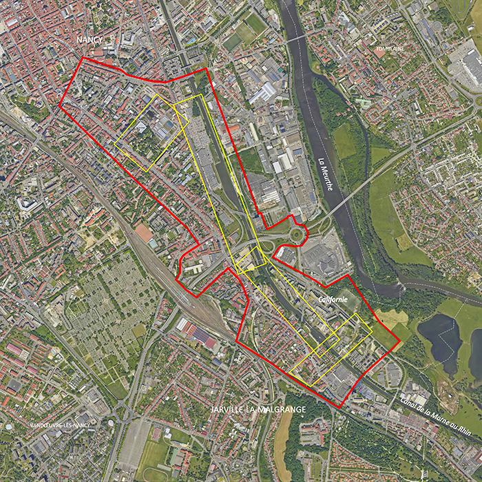
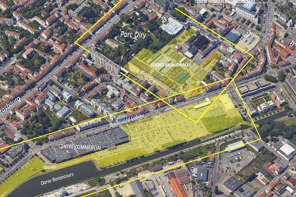
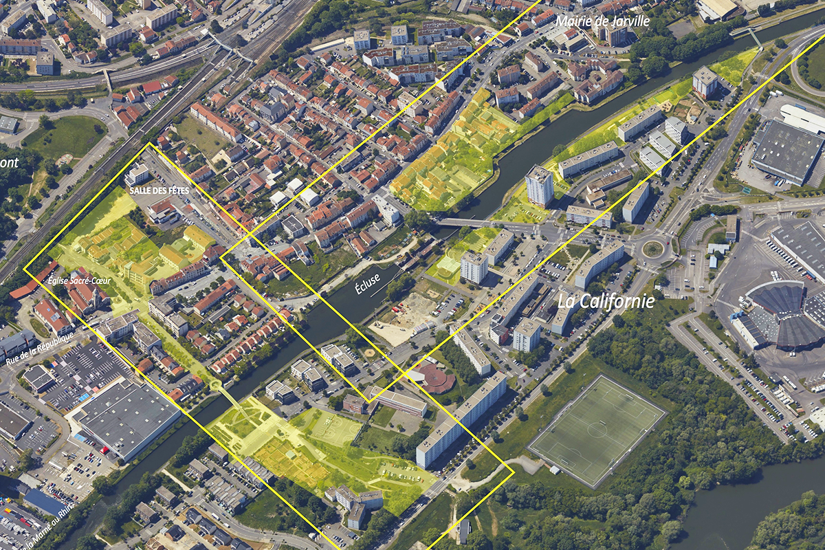
Reflection site 150 ha - Project site 12 ha, 25 ha, 15 ha, 10 ha
Site proposed by Métropole du Grand Nancy - Cities of Nancy and Jarville
Actors involved Scalen, Solorem, EPFGE, VNF, State services, social landlords (Meurthe & Moselle Habitat)
Owner(s) of the site Public and private
Commission after competition
- Guide plan and/or urban and landscape project management assignment
- Urban and architectural feasibility studies for prefiguration and experimentation purposes
- Architectural or landscape design and project management, public space project management
More Information
SITE/CONTEXT
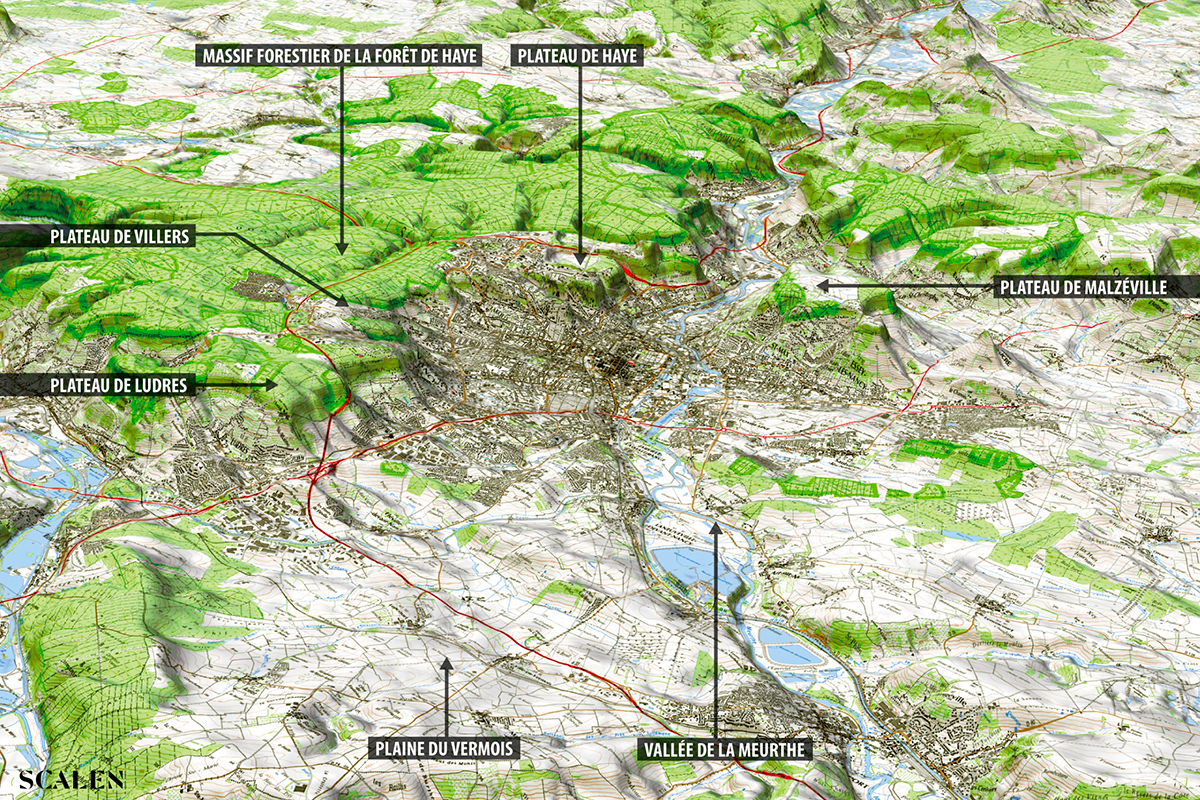
The Nancy metropolitan area is part of the Meurthe valley landscape: a major river system at the bottom of the valley, bordered by discontinuous hillsides opening onto wooded plateaus and agricultural plains. Historically, the city of Nancy and the surrounding villages were set up at a distance from the marshes and floodwaters
of the Meurthe, while craftsmen, boatmen and market gardeners settled along the water’s edge. During the industrial revolution, the digging of the canal from the Marne to the Rhin and the arrival of the railroads led to the establishment of major industrial facilities on the banks of the Meurthe.
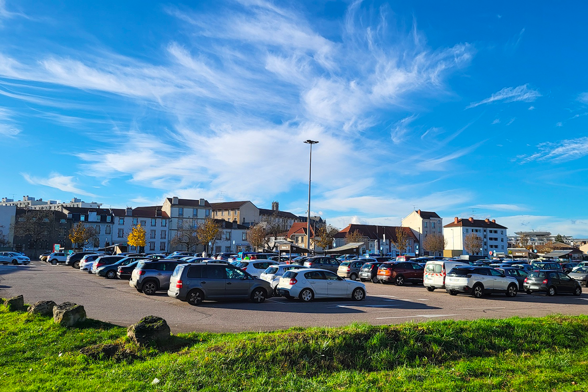
The second half of the 20th century was marked by the advent of the car - between bypasses and expressways - as factories withdrew and freight railroads were dismantled. The creation of the Californie district - on the site of the former Jarville blast furnaces - and the later construction of a shopping center on the former Saint-Georges railroad line, bear witness to these changes. The natural environment and hydrographic network have also been reshaped, with work to reshape the Meurthe river and the burial of several streams.
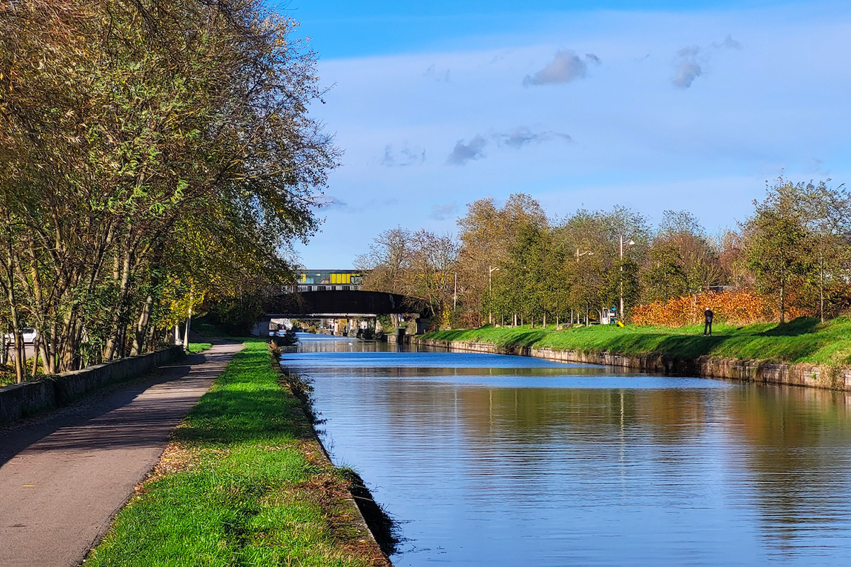
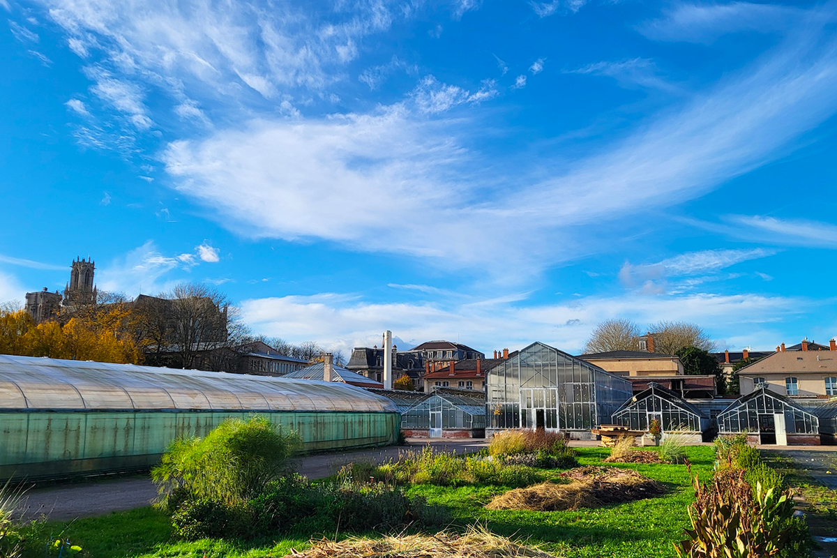
At the gateway to the old town, classified as a Site Patrimonial Remarquable, the Europan site stretches along the Marne au Rhin canal in the communes of Nancy and Jarville-la-Malgrange. On a metropolitan and local scale, this historic suburb appears as a city gateway and in-between-city area, cut off by the ring road and its interchange: flows and infrastructures act as separations rather than links between neighborhoods and residents.
The Grand Nancy metropolitan area and the towns of Nancy and Jarville want to restore the unity of this area in transition. The aim is to decompartmentalise parts of the city by restoring social and environmental continuity. The project is designed to enhance the heterogeneous urban heritage and work in harmony with the infrastructure. It also aims to create a high quality urban and landscape environment, recovering the natural ground and imagining a new relationship between the city and the canal.
QUESTIONS TO THE COMPETITORS
From the Californie district in Jarville to the edge of Nancy city centre, the site under consideration includes several opportunities for intervention. With the idea of resourcing social, landscape and ecological dynamics, the questions raised can be grouped under the headings :
Thresholds. How can we strengthen the social and economic dynamics of this metropolitan gateway? How can we overcome the effects of boundaries and perimeters, and create new porosities and accessibility between large urban areas? How do we deal with inherited infrastructures?
Links. How can we rediscover links and places between contrasting neighbourhoods that bear witness to different eras? How can new interfaces be created? How can we open up isolated areas and create new routes through the city?
Resurgences. How can water be revealed in the landscape and the urban imagination (buried streams,
a river kept at a distance, a canal to be re-enchanted)? How can we reveal the natural and hydrographic base? How can we enhance the value of plants and horticultural know-how?
Reactivation. How can we reinvest built heritage to be recycled, natural heritage to be enhanced, urban and social memories to be revived? How can we bring water back into the city? How can we reactivate uses in contact with water and restore qualities to the land?
Questions on the site
Madame, Monsieur, Dans l'éventualité d'impossibilité d'être présent à la visite de site, pourriez-vous m'indiquer si le procès-verbal de la réunion précisant les attentes de la collectivité sera publié ? Vous remerciant par avance,
The site visit report has been published on the Europan Europe Website.
The site visit movie has also been published - see folder "specific documents"
Bonjour, Auriez-vous des plans topographiques pour les parties : - Entre l'église Notre dame de Bonsecours, le gymnase du lycée Jean Prouvé, le canal et la tour Brot - Entre la rue de la république (quartier Papag), le canal et les tours du quartier Californie En vous remerciant.
All the info we could gather has been uploaded on the Europan Europe Serveur.
Bonjour, Auriez vous des informations complémentaires à nous transmettre sur le projet de marché d'intérêt local ? (programmation, besoins en termes d’infrastructure et surface, réseaux d’agriculteurs déjà identifiés ? ) Sera-t-il placé sur la friche à proximité de la Tour Brot ? En vous remerciant.
The Local Market (M.I.L) project is indeed to be located on the brownfield site near the Marcel Brot Tower.
The business park on the east bank of the canal has not been included in the Europan site and is currently being studied by the Greater Nancy Metropolitan Area.
We are not currently in a position to provide any information on these studies.
Bonjour, Vous évoquez la réactivation du tourisme fluvial, avez-vous déjà identifié des acteurs impliqués dans cette démarche ? Auriez-vous des documents permettant de localiser et de caractériser les polluants présents sur la friche du secteur Marcel Brot, ainsi que sur les vases du canal ? En vous remerciant.
During the site visit, Voies Navigables de France (VNF) indicated that the pollution identified during the studies on the Bonsecours dock is linked to the EQIOM cement plant, located on the east bank of the canal and still in operation today.
We are currently unable to provide a map locating this pollution.
Bonjour, Auriez vous des demandes auprès d’acteurs locaux (associations, organismes) pour des demandes de bail et de locaux auprès des services publics ? Auriez vous des documents réglementaires à transmettre sur la prévention des risques d’inondabilité de la Meurthe et des zones inondables sur le secteur de réflexion ? En vous remerciant.
We added some documents concerning the water flooding reglementations.
You can upload the files in the "new docs after launch" folder.
The QGIS data for the PPRI flood zones, the maps showing the 2012 flood zones from the Atlas des zones inondées (AZI) and the underground streams crossing the site have already been sent in the complete downloadable file:
FR-NANCY-SS-M03 (streams),
FR-NANCY-SS-MXX_PPRI (PPRI and AZI).
We are also sending the zoning maps and the regulations of the Meurthe Flood Risk Prevention Plan (PPRI).
Regarding the Atlas of Flooded Areas in Greater Nancy (AZI) related to the 2012 floods, two areas have been identified: at the M674 ring road on the municipal boundaries, and to the south on project site no. 4. These areas are linked to the presence of the Brichambeau and Moulin streams, both of which are underground.
This Atlas has no regulatory value; it simply indicates a need for vigilance linked to the previous flood of 2012 and urges people to avoid any actions that could prevent water from flowing properly.
Bonjour, Auriez-vous des informations plans, photos, histoire, concernant les bâtiments suivants : - Présidence de l’université de Lorraine, rue Lionnois - Faculté de pharmacie, rue Lionnois - Institut de formation en soin infirmiers, rue Lionnois - Maison médicale de garde, rue Lionnois En vous remerciant.
All the info we could gather has been uploaded on the Europan Europe Serveur.
Bonjour, Auriez-vous des informations plans, photos, histoire, concernant les bâtiments suivants : - Hypermarché Auchan, bd Lobau - Poste - Gymnase du lycée Jean Prouvé - Salle Françoise Chemardin En vous remerciant.
All the info we could gather has been uploaded on the Europan Europe Serveur.
Concerning the 3D model already downloadable on the server
For those who have trouble downloading the 3D file, please find an open link here:
Opendata on the "Région DataGrandEst" website : https://www.datagrandest.fr/portail/fr
This site is connected to the following theme
Re-sourcing from social dynamic A missing layer of urbanity is added on a territory with underlying complexities. In all these large sites, the question is how inhabit them, how to relate to them, how to add a human ecosystem while negotiating the pros and cons of the existing complexity. It may be to reconsider an urban interrupted development, to care wounds left or created by old or new infrastructures; to regenerate sub-standard housing or the damage left behind a brownfield, to reconsider a river or former agricultural fields.
Creating New Urban Relationships
Specific documents
Questions on the site
You have to be connected –and therefore registered– to be able to ask a question.
Fr. 16 May 2025
Deadline for submitting questions
Fr. 30 May 2025
Deadline for answers
Before submitting a question, make sure it does not already appear in the FAQ.
Please ask questions on sites in the Sites section.
Please ask questions on rules in the Rules section.
If your question does not receive any answer in 10 days, check the FAQ to make sure the answer does not appear under another label or email the secretariat concerned by the question (national secretariat for the sites, European secretariat for the rules).