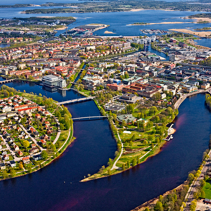
Karlstad (SE)
The Synthetic Site Folder and Site Brief are available for free.
Please register and login to access the Complete Site Folder.
- Synthetic site folder EN
- Site Brief EN
- Site on Google Maps
- Back to map
Data
Karlstad (SE)
Scales L/L
Team composition Architect non mandatory
Location Karlstad
Population 97 000 inhabitants
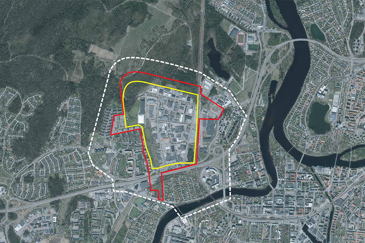
Reflection site 106 ha - Project site 71 ha
Site proposed by Karlstad municipality
Actors involved Karlstad municipality
Owner(s) of the site Karlstad municipality, private developers
Commission after competition Meeting and workshop with the municipality and the prize winning team(s). The proposals will form the basis for a citizen dialogue, a dialogue with politicians, and the development of a planning programme. The ambition is that the winning team will continue to work together with the municipality on the proposal in the planning programme.
More Information
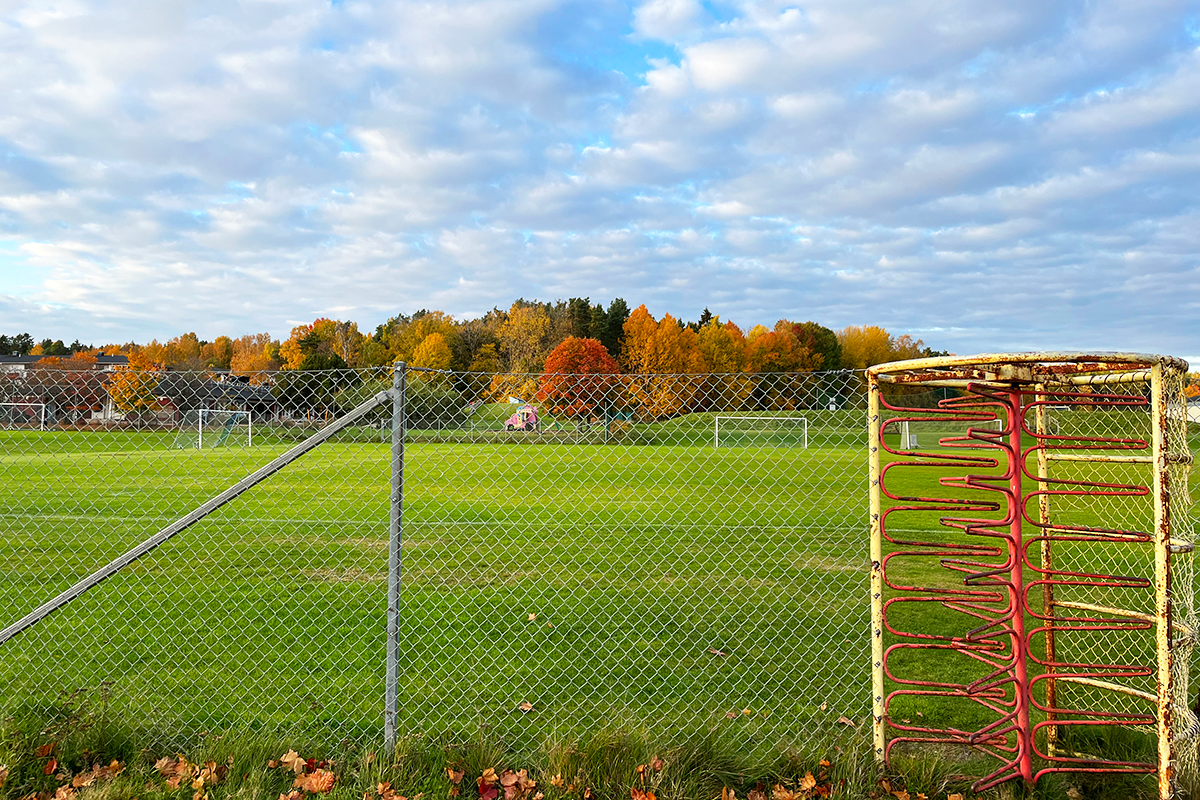
SITE / CONTEXT
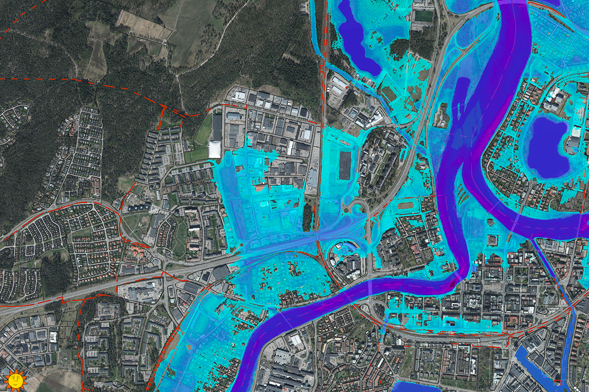
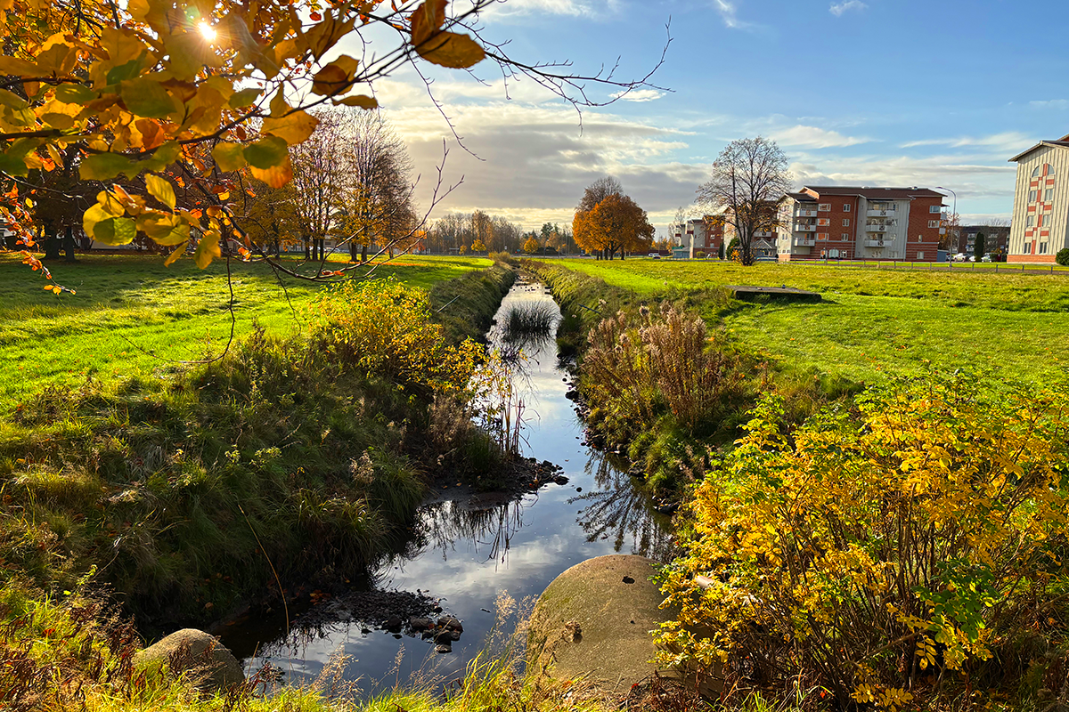
The project site includes Våxnäs industrial area and Låglandet Park, and presents a unique opportunity to shape the future Karlstad. Developed during the 1970s and designed for increasing car use, today the area is dominated by industry, commerce, and sports facilities, leaving it disconnected from its surroundings and unsafe at night.Våxnäs’ strategic location—just two km from Karlstad’s city centre—positions it as a key site for redevelopment into a vibrant, multifunctional district where housing, businesses, public infrastructure, and green spaces coexist. Flooding is a significant challenge due to Våxnäs’ flat terrain and clay-rich soil. Integrating water management strategies into public spaces is critical. Låglandet Park, central to stormwater management, could evolve into a multifunctional district park that blends flood resilience with recreation. Green infrastructure can transform flood-prone areas into assets for recreation and biodiversity, enhancing quality of life and connecting built environments with natural systems.
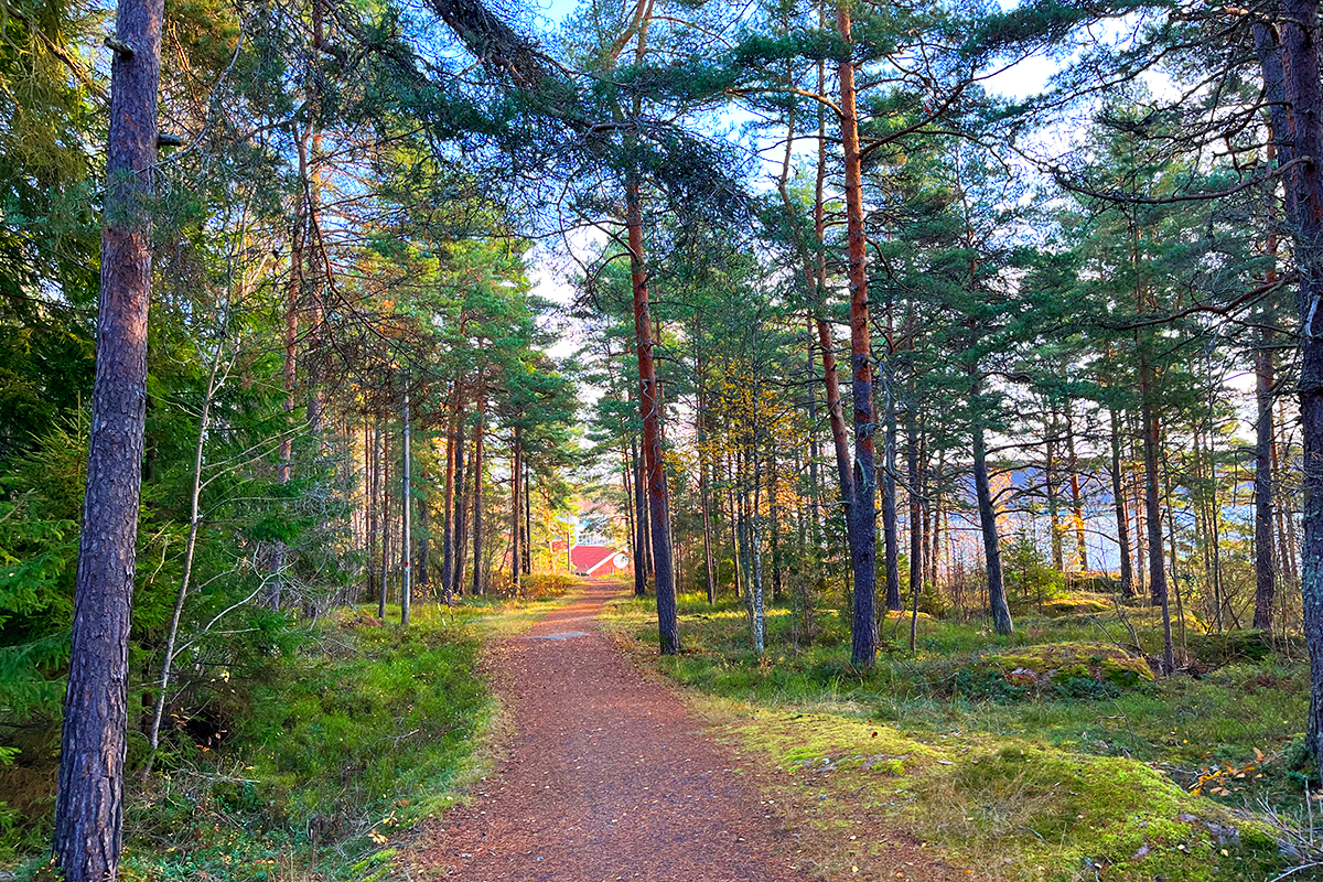
The I2-Forest, Karlstad’s largest outdoor recreational area and a great biodiversity asset, borders Våxnäs but remains underutilised due to limited access points. Developing green corridors and creating clear entrances can link Våxnäs with ecological networks and strengthen biodiversity. Similarly, connecting Våxnäs to the city centre and other districts through an expanded public transport network, alongside enhanced pedestrian and cycling infrastructure, will reduce car dependency and promote sustainable mobility.
Våxnäs’ redevelopment should be phased, considering existing resources to ensure a sustainable evolution. Key opportunities include the planned relocation of the bus depot, the reconfiguration of areas around the sports fields and Låglandet Park, the temporary use of spaces for cultural or recreational purposes, and the potential repurposing of vacant industrial lots. These incremental changes can catalyse further regeneration, supporting both economic and social sustainability/
QUESTIONS TO THE COMPETITORS
Participants are tasked with reimagining the area as a lively mixed-use neighbourhood, active throughout the day, that integrates a variety of housing, businesses, public spaces, and green infrastructure. The vision must address challenges such as flooding, connectivity, and social cohesion while leveraging existing resources and phasing strategies.
How can flood-prone areas in Våxnäs be transformed into assets for recreation, resilience, and biodiversity? How can water management strategies be integrated into public spaces to address flooding while enhancing quality of life? What strategies can strengthen links between Våxnäs and Karlstad’s green infrastructure, such as the I2-Forest and ecological corridors? How can Våxnäs prioritise pedestrians, cyclists, and public transport while reducing car dependency?
What strategies can ensure coexistence between human activity and the preservation of non-human life?
What phased transformation process and collaboration among stakeholders can ensure long-term success? What existing resources, such as industrial buildings and infrastructure, can be repurposed for sustainable development? How can key sites like the former bus depot and the reconfiguration of areas around the sports fields and Låglandet Park, serve as catalysts for regeneration?
Questions on the site
To what extent should the current ownership structure of the plots influence our design strategy? Are there opportunities for negotiation or transformation of ownership to support a cohesive vision?
It is certainly possible to propose changes to the current property structure to support a cohesive vision. This may even be necessary to achieve the objective of transforming the area from an industrial, storage, and commercial zone into a lively, human-centered and human-scaled district, and to identify attractive ways to complement existing businesses.
The extent to which property structures need to change is a question to balance with others in order to present a realistic and sustainable process for transforming Våxnäs. While property conditions naturally influence what can be implemented - due to economic factors and other practicalities - it is crucial to present a strong, well-grounded vision for the future: one that goes beyond ownership to support an integrated and long-term transformation that is positive for the city, the area and the stakeholders.
The current ownership of each plot should not limit the proposed vision of future development.
Is the municipality aiming for a comprehensive redevelopment and rebranding of the area, or is the focus on addressing specific challenges and problem zones within the site?
The task is to create a long-term vision for the transformation. The goal is not only to address specific challenges such as flooding and social issues, but to holistically study the area. We are committed to shaping an attractive future vision that the municipality and property owners can drive forward together. The result will be a transformed character and identity of the area.
The proposals need to balance how existing businesses and facilities are complemented in order to create a neighborhood that is appreciated, attractive, vibrant, and safe.
In reprogramming the area, must all existing uses be retained and integrated, or is there flexibility to modify, replace, or delete them if they don’t align with the proposal’s vision and future needs?
No, not all existing uses need to - and perhaps cannot - be retained and integrated. Some functions, such as storage facilities and parking lots, represent a very low-intensity use of land, while others contribute to urban life, provide workplaces, and can serve as destinations for people from other parts of the city. These uses play a positive role in the long-term transformation to create a mixed-use urban district.
Businesses in the area may also be proposed to relocate within the area or be completely removed.
Can we assume that it is possible to build basements to some extent on the site and the areas surrounding it?
Yes, basements can be included in proposals. Our flood guidelines allow basements, as long as they’re not used for living spaces or other areas meant to be regularly occupied. New buildings should be designed to avoid flooding during high water events. However, basement areas can be used for things like garages, storage rooms, or similar spaces where occasional flooding isn’t a major issue.
What is the accuracy of SE-Karlstad-SS-M5? It does not correlate well with the dwg. In many places it's highlighting trees that doesn't exist - like in the parking lot at Våxnäs res. area. Are there no valuable trees in the forest areas? Is there more information about the trees in the document- type of tree - thickness of the tree trunk etc?
SE-Karlstad-SS-M5 is based on an inventory of valuable trees conducted by the County Administrative Board in 2008. The inventory is therefore somewhat outdated, and it is likely that some of the trees no longer correspond to the current situation. However, it provides an overview of valuable tree structures in and around the area. The inventory is not comprehensive, and not all trees have been surveyed or marked in the DWG file.
The material from the County Administrative Board (the trees shown in SE-Karlstad-SS-M5) includes an inventory of avenue trees, hollow trees, and old/large-diameter trees. If any of the inventoried trees need to be felled, a consultation must be held or a permit must be obtained from the County Administrative Board.
Karlstad Municipality does not have a complete understanding of how the inventory was conducted in 2008, but the file mainly includes trees located in urban areas or cultivated landscapes. Forest areas have largely been excluded from this inventory. However, there are many valuable trees in the I2 forest. Directly next to the Våxnäs industrial area, there is forest with high and very high natural values. See the map titled "SE-Karlstad-C-M8" In these areas closest to Våxnäs, there are many older, large trees—mainly old, large Scots pines, but also broadleaf species.
New shapefiles and JSON files for SE-Karlstad-SS-M5, which include metadata with information about each inventoried tree, can be found under "0-New_Docs_after_Launch".
Apart from the removable parts that can be used in the proposed site, is it allowed to freely demolish or renovate the existing buildings? Can sectors other than buildings be used? Or are all private sectors off-limits?
Much of the land in Våxnäs is privately owned, which means that future development will depend largely on private interest in renewing the area. Therefore, a key aspect of the task is to propose how private land can be transformed in the long term to achieve the task of creating a long-term vision for transforming the Våxnäs industrial area into a vibrant, mixed-use district. This may involve demolishing or renovating existing buildings or changing other sectors.
It is not possible to see the questions, on the website, that we or other teams have asked...Can they be sent by email?
The Q&A section can be found on the Karlstad site page under the section titled “Questions on the site.”
If you have experienced any issues accessing it, we have also sent the questions and answers directly to all the team representatives for your convenience.
This site is connected to the following theme
Re-sourcing from natural elements In this family of sites, the potential of soils could guide the evolution of a site in a process of space’s regeneration, intensification or addition. The biological dimension of available land could trigger new ecological and social relations, and interactions between organisms for a mutual benefit. From the horizon to the scale of the microorganism: which is the capacity of soils to infiltrate biodiversity provide ecosystem services and give continuity to the territory?
Reactivating Soils
Specific documents
Questions on the site
You have to be connected –and therefore registered– to be able to ask a question.
Fr. 16 May 2025
Deadline for submitting questions
Fr. 30 May 2025
Deadline for answers
Before submitting a question, make sure it does not already appear in the FAQ.
Please ask questions on sites in the Sites section.
Please ask questions on rules in the Rules section.
If your question does not receive any answer in 10 days, check the FAQ to make sure the answer does not appear under another label or email the secretariat concerned by the question (national secretariat for the sites, European secretariat for the rules).