La Nive (FR)
The Synthetic Site Folder and Site Brief are available for free.
Please register and login to access the Complete Site Folder.
- Synthetic site folder EN | FR
- Site Brief EN | FR
- Site on Google Maps
- Back to map
Data
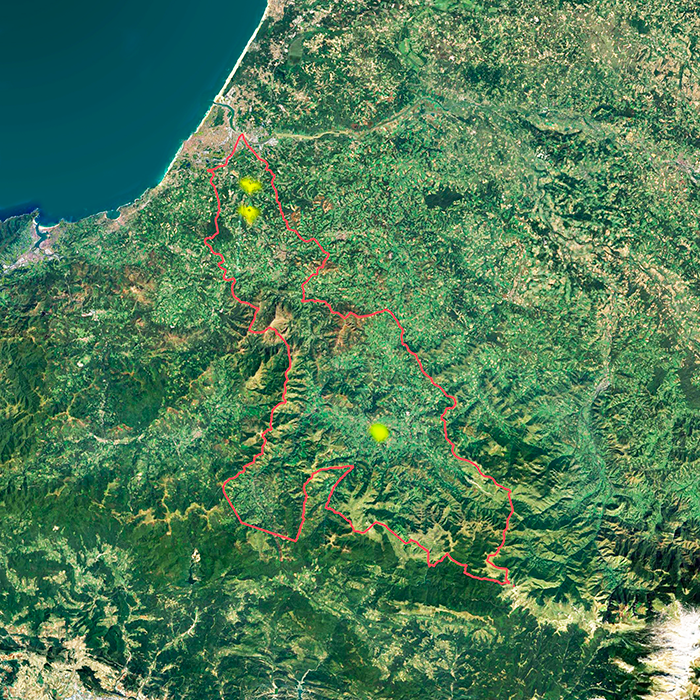
LA NIVE (FR)
Scales XL/S
Team composition Architect mandatory
Location River Nive area
Population 97 600 inhabitants
Reflection site 110 000 ha - Project site Saint-Jean-Pied-de-Port: 15,4 ha, Ustaritz: 47,4 ha, Villefranque: 27,1 ha
Site proposed by Pays Basque Agglomeration Community
Actors involved Pays Basque Agglomeration Community, Municipality of Ustaritz, Municipality of Saint-Jean-Pied-de- Port, Municipality of Villefranque
Owner(s) of the site
- Saint-Jean-Pied-de-Port: City of Saint-Jean-Pied-de-Port
- Ustarritz: Emile Larroulet SA Establishments, Municipality of Ustaritz, private owners
- Villefranque: City of Villefranque, SNCF, EPIC l'office 64 de l'Habitat, Ass. d'Education Populaire St Barthélemy de Villefranque, SCI Eptitou, private owners
Commission after competition Study and project mission(s) to further develop strategic proposals, feasibility studies on the project site, architectural, urban, or landscape project management mission(s).
More Information
SITE / CONTEXT
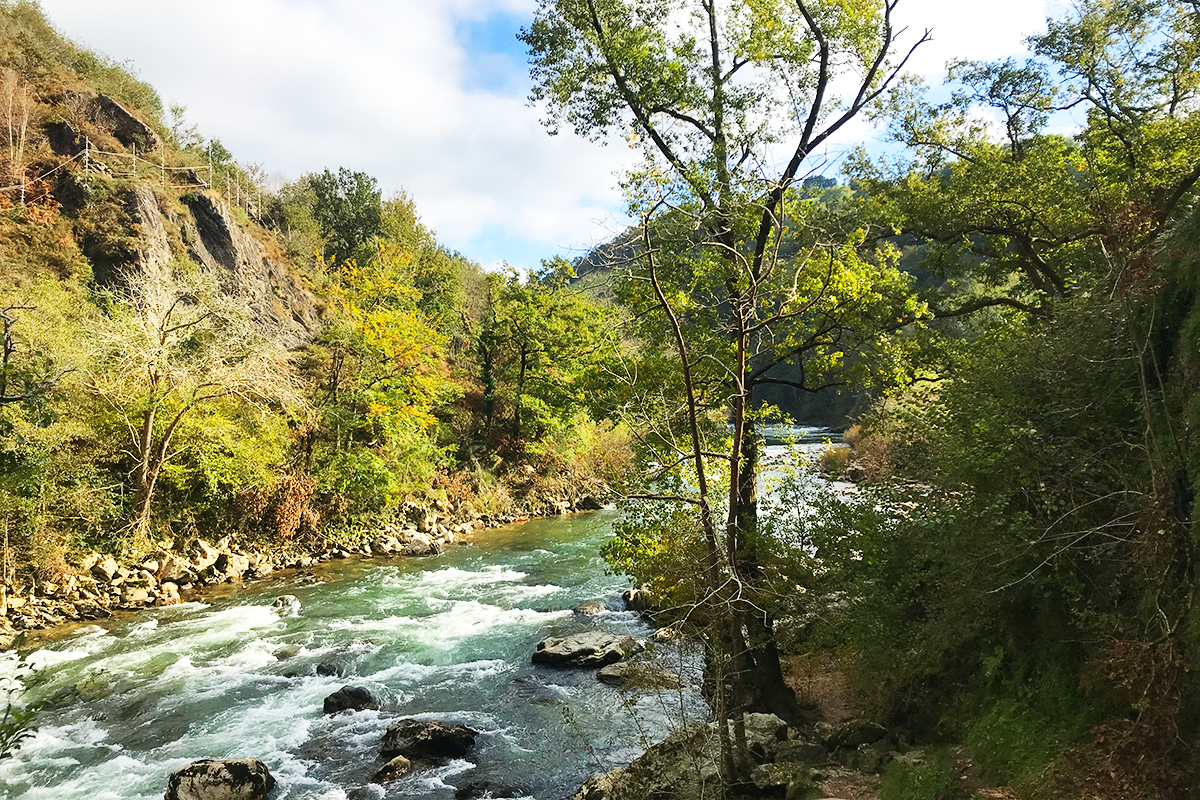
The Nive catchment area is a multifaceted space where water and humans maintain an ambivalent relationship characterized by conflicts and temporary balances.
It is a protected natural site located within a developing economic zone and a rapidly growing population, an entity that illustrates the issues surrounding the management of commons, and a governance territory tested by the practical challenges of ecological transition and adaptation of modern societies.With this large territorial reflection site and its three micro-territory project sites, they provide a platform to address issues covering the three dimensions of the theme of this 18th Europan session.
Water plays an ambivalent role in this territory. It is both a life’s source for biodiversity and human uses, whether recreational or economic, but it is also a source of risk due to increasingly frequent and severe floods.Water, its landscape, and its history also have a dual symbolic and poetic role, serving as a vehicle for sought-after territorial cohesion between contrasting urban, rural, and natural spaces, while also creating remarkable landscapes for residents, users, and tourists, as seen in the cycling route project along the Nive. Lastly, despite the perception of a region with heavy rainfall, water is a threatened resource due to the growing risks of drought caused by climate change and increased consumption driven by residential and agricultural factors.
The livability conditions for both humans and non-humans in the Nive territory face the risk of losing balance due to residential, tourist, and recreational pressures, as well as changing lifestyles, particularly new uses of rural spaces. The heightened awareness and means of protecting biodiversity require us to reconsider our coexistence practices and imagine future balances. In this context, tourism plays an important and growing role in the economic development of the Basque Country.
It represents the greatest risk of imbalance with seasonal flows and concentrations in certain sections of the Nive that endanger local biodiversity and create conflicts with residents.
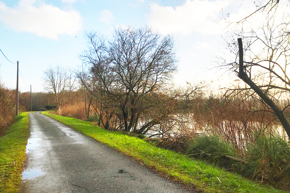
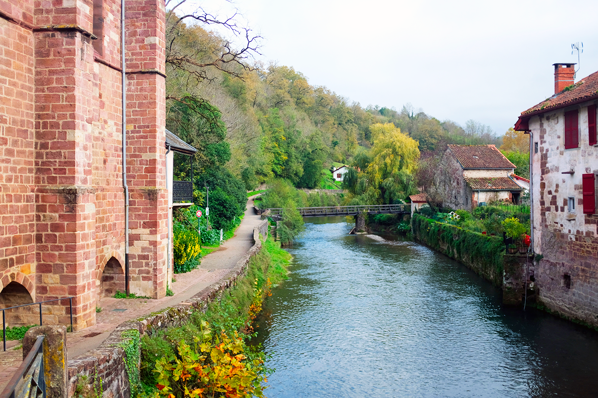
The human transformed landscapes and the built spaces along the Nive bear witness a long history with the river, from ancient heritage such as the Saint-Jean-Pied-de-Port Citadel and the towpath, to more recent structures like the Arki Mill and the Ustaritz gravel pit lake.This existing fabric constitutes a valuable source of material and space to transform, to imagine future programs and places of life for both humans and non-humans, with potential to be reevaluated in light of the challenges posed by this complex territory.
QUESTIONS TO THE COMPETITORS
Within the larger territory of the Nive catchment area, three project sites along the river become territories for development. From upstream to downstream, these sites are located in Saint-Jean-Pied-de-Port, Ustaritz, and Villefranque.
Three contrasting situations along the Nive witch illustrate this large territory’s challenges in their own way:
-
The challenges of coexistence between residents, users, tourists, and wildlife; and the balance between creating landscapes suited to human uses and protecting the biodiversity present.
-
The challenges of renewing the interfaces between inhabited spaces and the river, balancing the desire for proximity and orientation of towns and centers towards the Nive with the management of flood risks.
-
The challenges of large-scale territorial cohesion around the river, notably through the towpath.
The task will be to question these sites and for the candidates, to imagine pilot projects that demonstrate the possibilities for an evolution of the Nive territory, specific to the particular situations, landscapes, and built environments, while being a representation of the challenges faced by the catchment area.
Questions on the site
Bonjour, Allons-nous recevoir les plans des bâtiments existants (type relevés intérieurs) qui sont inclus dans les zones de projet ? Merci d'avance,
Everything we have collected is online.
Look in the “new docs after launch” folder, there are plans for the flour mill and the PPRI.
Bonjour, Nous souhaiterions savoir s'il était possible d'avoir accès au : - SCOT / PADD en cours de validation - Des données sur les risques à l'échelle de la communauté de coomune - des carnets communaux du PLUi et PLHi, En vous remerciant de votre retour,
Please look under this link:
https://www.communaute-paysbasque.fr/logement-et-urbanisme.
Concerning the risks, under this link:
Bonjour, nous avons bien reçu le compte-rendu de la visite de site, que nous avons téléchargé en pdf. en revanche il nous est impossible d'accéder au lien contenant les plans de la Minoterie. Pourriez-vous nous les transmettre via le dossier complet du site de la Nive ou tout autre moyen ? Merci d'avance, Cordialement.
The plans are online.
folder “new docs after launch.”
Bonjour, sur le site de la Nive, est-il possible d'obtenir des plans comprenant des courbes de niveaux pour évaluer la topographie des différents sites ?
In the various folders, particularly those of the “project site,” you will find documents with contour lines in .dwg format.
The contour lines are every 5m (in principle).
Geoportail can provide you with additional useful information, as can Qgis.
Bonjour, Peut-on évoquer dans notre projet des solutions techniques impliquant un bureau d’étude local sans l’intégrer formellement à l’équipe ? Faut-il le mentionner explicitement ou rester général ? Merci pour vos précisions.
Of course you can work with a local ingeneer and with all the people you think that are appropriate for your proposal.Eurpan encourages multidisciplinary teams!
You don't need to mention those people (it's only an ethical question for you - do you want these persons to be winning and appearing with you?)
Lors de la visite du site, une maison située à proximité de la Porte Notre-Dame a été évoquée comme potentiel site de projet. Des documents ou éléments complémentaires (plans, photos, état existant) concernant ce bâtiment sont-ils disponibles ?
We added in the "new docs after launch" folder, some drawings about the hause (2024-06-28- BDT_2 rue d'espagne SJPP.pdf)
Est-il envisageable d’intégrer et de nommer des acteurs du territoire (associatifs, entreprises, institutions) dans la réflexion de projet ?
Yes of course! Ressourcing.
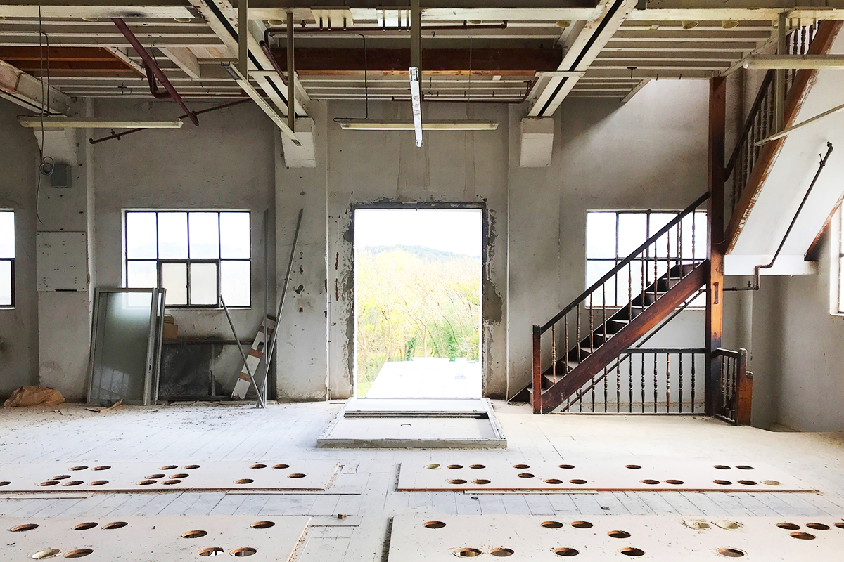
Is not really clear which parts of the mill complex and buildings have to be kept and which ones can we demolished, transformed or re-imagined. Could you provide more information about that?
New documents have been put online in the folder "new docs after launch".
You will find plans of the mill. You can developp your proposal on the whole building.
Is the Secteur Sainte Eulalie in Saint-Jean-Pied-de-Port to be proposed by the participants? In the map it is outside the project site area.
No, the Sainte Eulalie sector is already the subject of a mixed-use development project comprising mainly housing, facilities, and public spaces.
In the brief of Saint-Jean-Pied-de-Port is it said to keep the existing and future programs, do they have to be kept in the exact same location? Can they be proposed in new locations?
The candidates are free to propose new locations for these programs if they estimate that it is relevant in their projects.
Is the parking in the rampant area to be kept in Saint-Jean-Pied-de-Port?
If your proposal considers that it is not in the right place and should be relocated, nothing is set in stone.
Is the camping to be kept in the same location in Saint-Jean-Pied-de-Port?
The camping is there where it is.
If your proposal considers that it is not in the right place and should be relocated, nothing is set in stone.
Is there more info about the specific allocation of the future museum in Saint-Jean-Pied-de-Port? Where exactly in the Rue de la Citadelle is it going to be planned or where in the Porte d’ Espagne? How much can be proposed by the participants?
The competition is not aboiut the museum of SJPP.
Can the museum be proposed in the free building in 2 rue d’ Espagne in Saint-Jean-Pied-de-Port?
The candidates are free to propose to locate the museum in the building in 2 rue d'Espagne.
Are there available plans of the vacant building in 2 rue d’ Espagne in Saint-Jean-Pied-de-Port?
All the documents we could gather are posted in the "new docs after lauch" folder.
We do not have the plans of the building you are asking for.
Should we plan the Eyheraberry bridge area assuming swimming is not allowed in the river? Is swimming going to be allowed in the future?
What does it mean to swim in a preserved or protected area? What kind of pressure will you impose to nature or what kind of citizen awerness does it need?
How could you make it happen?
If you are pushing this proposal it is very challenging and prospective, in the scope of the compétition.
As the areas are protected, how much can be proposed altered around the Eyheraberry bridge in Saint-Jean-Pied-de-Port?
The area is protected. Your answer needs to take that into acount and be very strategic and prospective about it.
The answer needs to care about the existing conditions, the existing natural élements and the tourist end local inhabitants pressure.
That's the whole delicate object of this site!
Exactly which building is supposed to be demolished in front of the church in Villefranque? Do we assume that the building will not be demolished?
You can assume the building will not be demolished and consider that it's not an important element of your proposal.
Where exactly is the Mendiburua farmhouse in Villefranque?
here it is:
https://maps.app.goo.gl/fM8SS7Kph5pxtCQi7
Regarding the paths, and the stretch between the Pasarela and the Mendirerria path, where exactly is the connection expected? In front of that, the Halage path runs uninterrupted. Is a connection expected on the right bank, between the Mendiberria path and the Yoanaherrenia path, next and along the train route? Or in the opposite bank with bridges?
Up to you. Where you think it will be the more accurate.
Can the loop idea in Villefranque be explained diagrammatically in a drawing? In the video is also talked about the area Florida and Ansot, but it is not clear where those areas are. After reading the brief and watching the site visit video it is still not really clear to us.
Please check the "new docs after launch" folder. I just added a documents called "chemin de halage.png"
If the connection is done between the Llailanea path and Mendiberria path, the length is around 700 m, where are the 300 m measured, as referred in the brief in Villefranque?
Yes the length is around 700m, not 300m.
Are new bridges allowed in Villefranque?
Keep in mind the various places along the Nive are very tiny and without a lot of money.
If you propose some new bridges, you will have to think about something very challenging in termes of costs and technics (low-tech?).
In the case of proposing new paths / connections, how is that supposed to be managed with the owners of the affected land in Villefranque? Are we free to propose the connections without considering that topic?
The question of land ownership is legitimate: if your proposed path design strongly reflects the public interest and is relevant, then buyback/expropriation procedures may be considered.
These questions will arise after the competition, when considering the implementations.
For the non-French speakers, it is harder to find the referred links (PAPI, PPRI, SCOT) referred in the visit summary PDF, could you please provide the links?
You will find on the Europan Europe folder "new docs after launch", the PPRI from la vallé de la Nive.
It's a document about flooding issues.
Concerning the PAPI, it is not ready yet for the Nive valley.
Concerning the SCOT, please try this page (a lot of information):
https://www.scot-pbs.fr/publications/
Can we do proposals for the “parking in transformation” in Villefranque?
You can, but it might not be relevant if the the parking is already beeing transformed.
Bonjour, Lors de la visite, on nous avait informé de l'existence de plans de niveaux de la Minoterie, est-il possible de les récupérer ? Existe-t-il un relevé du bâtiment du 2 rue de l'Espagne à SJPP ? D'avance merci
Please look into the new documents added in the folder "new docs after lauch".
You will find part of your answers there.
In the location Ustaritz, there is a concrete company called Locatrans, located close to the Graviere, does it have to stay there? Can that area be transformed?
The company Locatrans is still in activity and close to the gravière (the lake)...
If you plan to move it, it might be in a phasing process.
Nothing is forbidden in the europan competition. At your own risks!
The provided DWGS have topography lines, but they do not have the height of each topography line, could we receive that information?
For exemple, on the "FR-LA_NIVE_USTARITZ-PS-M1", the topography lines in magenta, on the .dwg file, have a height of 5m.
If you don't have QGIS, you can confront it to other maps where you can find some heights, please go the this site which might help you:
https://www.geoportail.gouv.fr/carte
This site is connected to the following theme
Re-sourcing from natural elements In context of global warming, to live and to re-dynamize inhabited milieus thanks to water is a strong driver for re-sourcing ; crossing the challenge to adapt to risks (flooding, marine submersion, coastline withdrawal, drought…) and to restore ecological milieus to improve quality of life, health and joy of every day.
Dealing with Water
Specific documents
Questions on the site
You have to be connected –and therefore registered– to be able to ask a question.
Fr. 16 May 2025
Deadline for submitting questions
Fr. 30 May 2025
Deadline for answers
Before submitting a question, make sure it does not already appear in the FAQ.
Please ask questions on sites in the Sites section.
Please ask questions on rules in the Rules section.
If your question does not receive any answer in 10 days, check the FAQ to make sure the answer does not appear under another label or email the secretariat concerned by the question (national secretariat for the sites, European secretariat for the rules).