Malmö (SE)
The Synthetic Site Folder and Site Brief are available for free.
Please register and login to access the Complete Site Folder.
- Synthetic site folder EN
- Site Brief EN
- Site on Google Maps
- Back to map
Data
Malmö (SE)
Scales L/S
Team composition Architect non mandatory
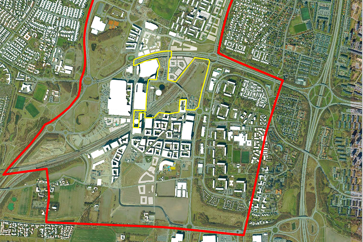
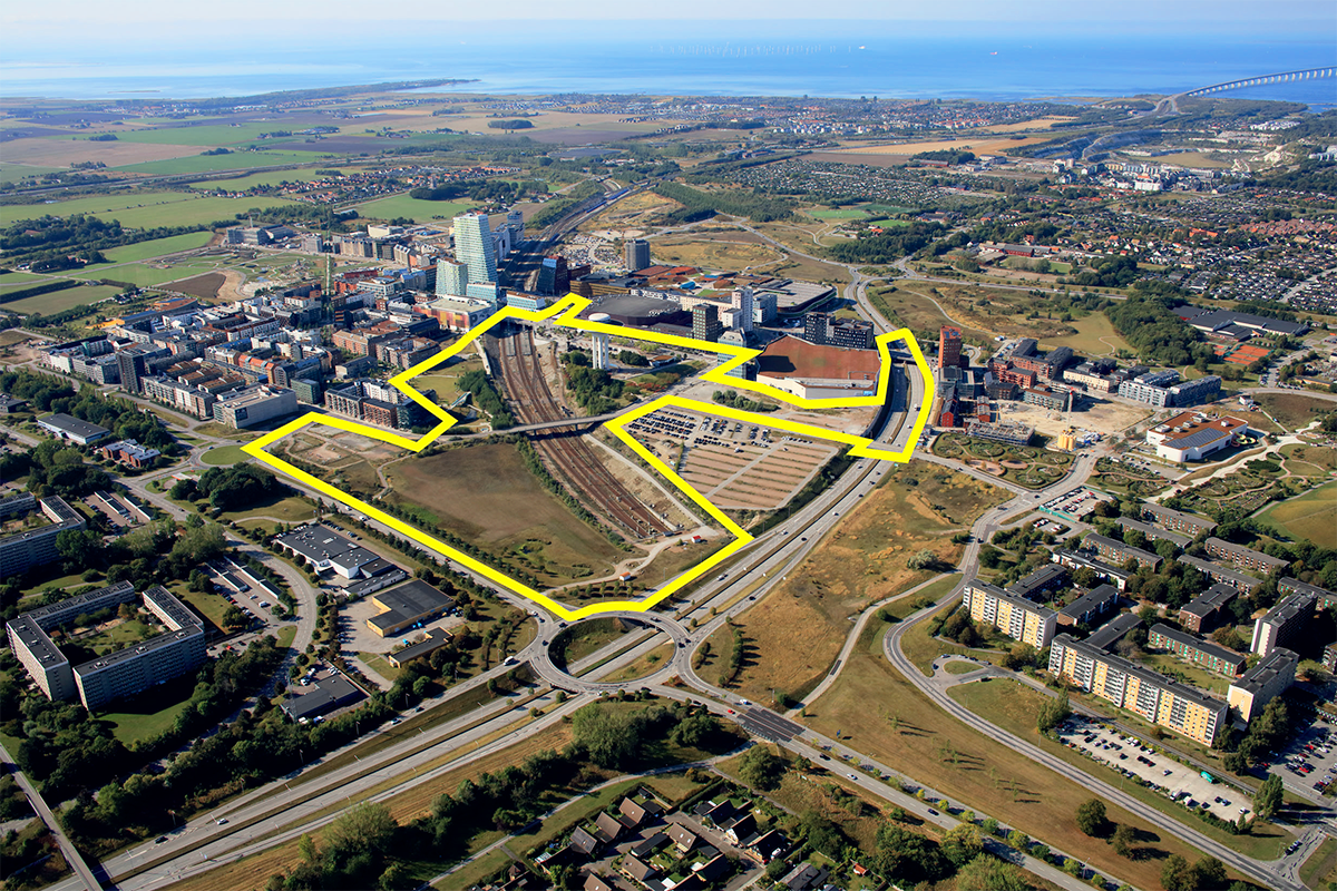
Location Hyllie, Malmö
Population Malmö 360 000 inhabitants
Reflection site 4 850 000 kvm - Project site 404 000 kvm
Site proposed by City of Malmö,The Swedish Transport Administration, PEAB
Actors involved City of Malmö,The Swedish Transport Administration, PEAB
Owner(s) of the site City of Malmö,The Swedish Transport Administration
Commission after competition The prize winning team(s) will continue to work with the competition assignment in a workshop with City of Malmö, The Swedish Transport Administration and PEAB. An option for continued work, such as workshops, presentations, strategic spatial investigations, various planning documents, illustrations, drawings and citizen dialogues, may be considered after the completion of the competition.
More Information
SITE / CONTEXT
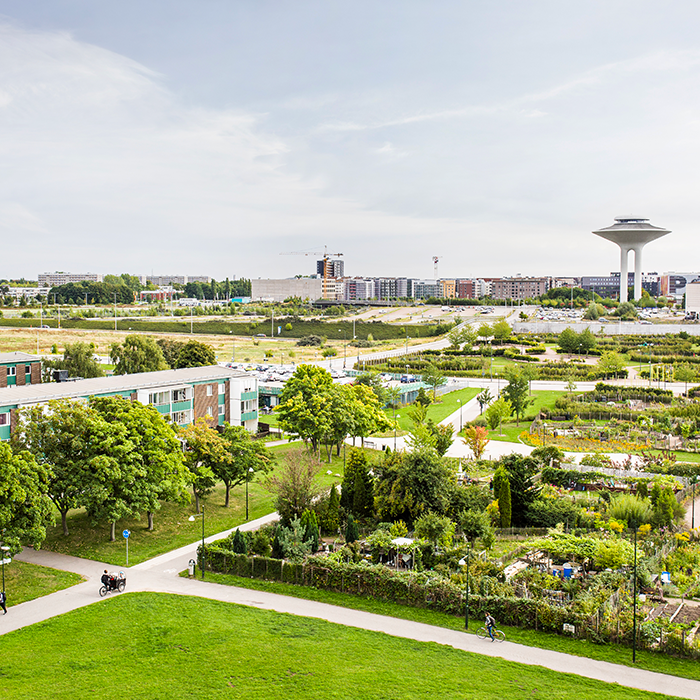
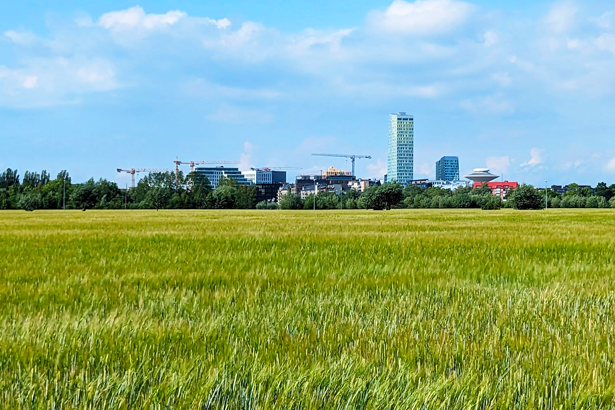
Malmö is Sweden’s third-largest city and a dynamic part of the Öresund Region, where Sweden and Denmark are linked by the Öresund Bridge. The city has evolved from an industrial town into an international hub for sustainable urban development, innovation, and creativity. Malmö is known for its young and multicultural population, as well as its progressive ambition to create a city defined by equality, climate neutrality, and sustainable development.
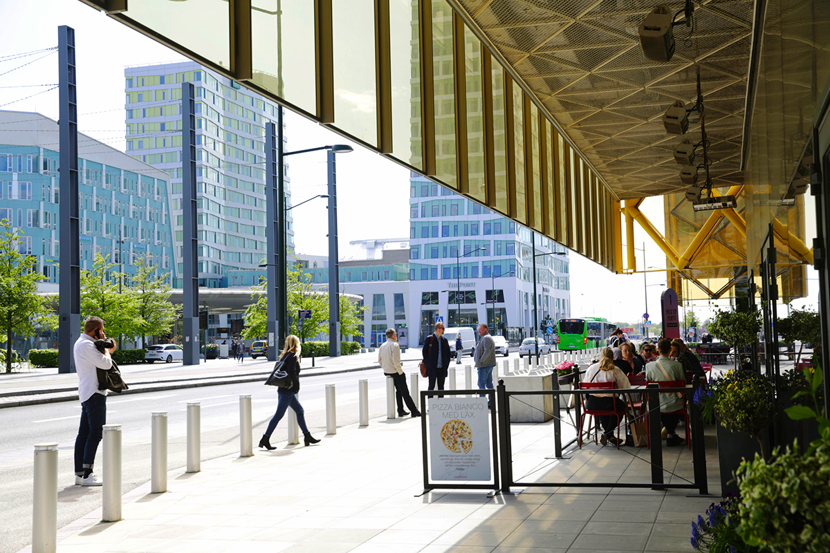
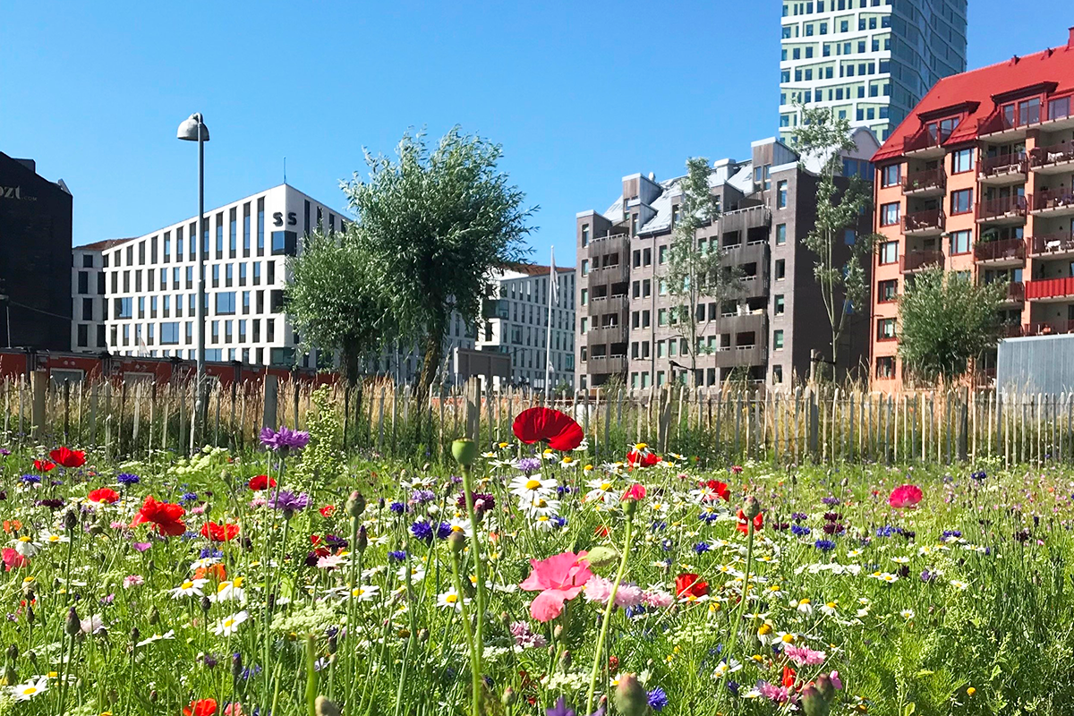
Hyllie is a district in southern Malmö whose strategic location is a driver of the city’s sustainability goals. Hyllie Station is a key part of the regional and international infrastructure, positioned as Sweden’s first station for travellers arriving from Denmark. The district is planned to become Malmö’s second city centre, featuring a mix of housing, work, and recreational spaces for 25,000 residents and 15,000 workers.
The competition task focuses on overcoming the physical and mental barriers created by the railway tracks and other major traffic routes.The aim is to strengthen connections within Hyllie and between neighbouring areas, promote a sustainable lifestyle and develop innovative and inclusive ideas that will make Hyllie a model for future urban development and a central part of Malmö.
While Malmö’s mild climate allows for year-round cycling, the colder months and wind create challenges for outdoor spaces.The proposals should improve the urban environment for out- door activities and social interaction all year round. In Hyllie, the flat landscape meets the city’s highrise buildings, adds an additional challenge.
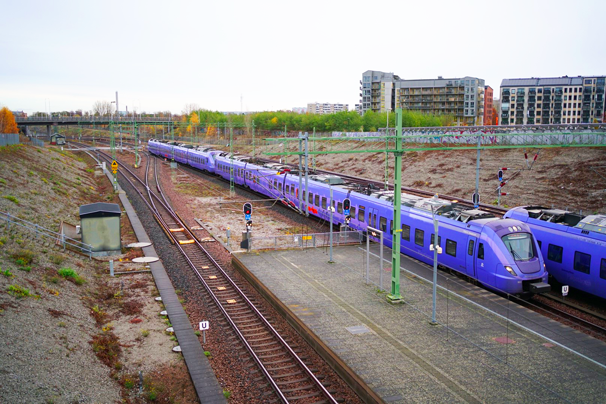
Urban development in Hyllie is now ”halfway” complete, with 8,000 residents and 12,000 workplaces. The railway tracks that, in the early 2000s, brought a station and urban development to valuable agricultural land now exist in a very different context. The ring road, which during the expansion of the social housing area served as a kind of city wall, still functions as a key link. However, the neighbourhoods it divided have now placed it in a new spatial context. There is now a need to reimagine these barriers.The integrated perspective of the city and its infrastructure is a prerequisite for the competition.
QUESTIONS TO THE COMPETITORS
How can the spatial impact of barriers in Hyllie be redefined to strengthen connections - particularly for pedestrians and cyclists - between existing and planned areas, while preserving the functionality of transport infrastructure?
How can Hyllie be developed to offer values and functions in the form of more culture, everyday life, small-scale commerce, and restaurants?
How can the area’s history and cultural background be integrated into urban planning to reinforce a sense of place and cultural anchoring while creating a vibrant and sustainable district?
What innovative design solutions can minimize the negative effects of noise and wind, improve the microclimate, and create high-quality living environments in Hyllie?
How can these solutions contribute to making Hyllie a record-setting green district that seamlessly connects the city, infrastructure, and countryside?
Questions on the site
As a part of the Site Visit, a future park next to the Malmö Mass is mentioned (between #5 and 6). Can any further details or plan regarding this be shown? And what is the name of the future park?
The name of the park is “Mässparken”. This refers to the adjacent “Malmömässan”, which is the fair hall east of the park.
The park is currently being built and will be finished in December 2026. The park contains a stormwater pond and can accommodate up to 11500 cubic meters of water in case of a cloudburst event. See separate files under "0 New documents after launch/Mässparken". Illustrationsplan_Öster om Mässan , Dp 5530 and Illustration Mässparken 1-3
Is it possible to have the land use map and future plan of the site with full legend?
See file Legend for maps 2D och 3D in the "0 New documents after launch"
Which elements from the site (Infrastructure, Buildings, Topography, Facade) that we can not change ?
Proposals should think of the built environment as a resource, following the competition brief. Still, there are elements that are harder to change (ie. remove, demolish, redesign) than others.
Generally, the competition task specifies that “It is not possible to change the design or function of existing buildings. The urban structure in planned areas is fixed. The functionality and/or capacity of Annetorpsvägen, the railway, and the water tower, including their layout, profile, and speeds, must be preserved.” (p 18). Note that the water tower is a protected object.
Relating to topography, proposals should include thoughts about stormwater management. What the topography of the parks does in terms of functionality needs to be maintained – ie. a redesign that removes this function needs to show that stormwater management is possible somewhere else.
Relating to infrastructure, what cannot be changed is the technical design and capacity of both railway and Inre ringvägen/Annetorpsvägen. When it comes to access roads to the tracks and signalling equipment, it is what these provide in terms of functionality that should be maintained. Note that if ERTMS is implemented on this section of track, the number of technical trackside installations may need to increase (Appendix 2, p 24).
Can we have any information about existing wildlife, such as observed bird/pollinator distribution etc. ?
See file Findings birds pollinators plants in the "0 New documents after launch" folder.
The map is an extract from the Swedish species portal, which is a system for reporting and searching for species observations in Sweden. The yellow dots indicate individual finds and the blue dots indicate clusters. The larger yellow areas are only divisions into different sub-areas. The black rings on the map indicate that there is uncertainty in the accuracy of the location of the observations. Relatively many species observations have been made within the site. This is largely due to the large portion of ruderal land within the site. Of the birds that have been observed at the site, it is worth mentioning the black redstart (Phoenicurus ochruros) and the Eurasian oystercatcher (Haematopus ostralegus). Both of these birds are red-listed in Sweden. Of the flowers, it is particularly interesting to mention the cudweed (Filago vulgaris) and the European violet willow (Salix daphnoides).
What is the existing plan for future green connections in the site ?
They are shown in map SE-Malmo-C-M1 (green connections and park, existing and future) and SE-Malmo-PS-M2, now in the "0 New documents adter launch" folder (parks according to detail plans). In addition, there are no further strategies for green connections in Hyllie or in the study site area. It’s much welcomed if you to do your own analyses and identify connections that are not shown in these maps. We see that it is of extra importance to find solutions that connect larger green spaces with smaller ones - with extra focus on creating connections across the boundaries between the city districts.
How much can we change or modify the use of the water tower ?
The water tower is to maintain its current function and structure. It is a protected object and therefore cannot be changed. Public functions such as restaurants are not allowed. If desired, the lighting, fencing and surfaces surrounding the tower can be adjusted, but need to maintain their current functions.
Given the space between Arena and Hyllie Station is on an overpass above the railway, what is the height, depth limitation e.g. restriction due to utilities underground/weight restriction due to overpass ?
The overpass is dimensioned for its current use, meaning that weight restrictions are reached through how the square is designed as of today – eg. buildings, vegetation, fountains and lights as well as the weight of traffic consisting of private vehicles and buses. Buildings on the overpass are specially designed to fit within the specifications of the structure. No further loads can be added without reinforcing the loadbearing structure.
This also means that the overpass is designed for the context it is in, and therefore not applicable as a template for eventual, additional, overpasses.
Concerning depth limitations, the retaining walls supporting the overpass are supported by a compact backfill with a slope of 1:1,15 (sections A-A and B-B in file A1-30851-A.pdf - Swedish only, in the "0 New documents after launch" folder). This means that approx. 23 meters behind each retaining wall have limitations for larger underground work.
What is the people capacity of the space between Arena and Hyllie Station ? Is there any existing strategy for people movement between the two places ?
When the square was planned, there was a clear request from the police that there should be at least 100 meters between Hyllie station and the main entrance to the Arena. This distance is needed to manage large crowds. There is no exact number for how many people should be able to be in the square at the same time, but it is good to keep in mind that the capacity for the arena is 15,000 visitors. The square should also be able to hold a large part of the visitors if the arena needs to be evacuated.
The fountains and hedges on the square are all lined up in the same direction to facilitate ease of movement between the arena and the train station.
What is the capacity of the car park and bike parking area next to the water tower ? Can we reduce the number and area of car parking at the site ?
The area north of Hyllie parksgatan ( Dp 5530 in the "0 New documents after launch" folder ) is no longer a car park.
It’s important to note that the area next to the water tower is not a car park, but a parking area for buses that is serving both replacement traffic for rail, but also bus transports to the arena. From about 2027, all regional buses to and from Hyllie will operate on Arenagatan. The buses will turn around on the surface. The city is open to a completely different type of bus terminal without small, detached landing islands, but the function and quality must be retained. Soon the city will rebuild this part of the street, Arenagatan, so that it becomes safer for traffic, greener and more adapted for bus traffic. The bike parking is well used by commuters so the number of bike-parking must be retained.
Can we have the detail plan of the constructing park North of site with a big pond ?
See separate file, DP 5530 (in the "0 New documents after launch" folder) för the area next to Malmömässan. For the empty field west of the rails there is no current detail plan.
Is there any regulations or limit in designing the slope buffer to the railway? Will there be any alternative connection to the railway using that slope now or in the future?
Slopes bordering tracks typically have an inclination of 1:1,5-1:3. 1:2 is the most commonly used. For reference, see typical cross-sections in TDOK 2015:0198 drawing 5.3 and 5.10 (Swedish only). For inclinations steeper than 1:1,5, retaining walls are needed.
As of now, there are no plans to remake the configuration of access roads to the tracks. However, as long as the functionality of them (eg. temporary storage of rail parts, access for rail-road vehicles) is upheld, it is possible to design them in another way.
Note that Hyllie station has island platforms, situated between the tracks.
Since we do not have access to all the layers in the Malmö map, we were wondering if you could share the layers with us—preferably in DWG or DXF format—for current land use, as well as a map showing the area's services and functions, such as schools, learning centers, health clinics, shops, and similar facilities.
This information is not available in DWG or DXF format. Please look at the Stadsatlas for information about localisations for those functions. https://stadsatlas.malmo.se/stadsatlas/
According to the brief all the area of Hyllie will accommodate 25000 residents and 15000 workplaces by 2040. Do those numbers include the project site and in that case how many residents and workplaces are expected to be accommodated within the limits of the project site?
The above mentioned figures are guidlines for the whole of Hyllie. They are both indicators of the future size of Hyllie and planning tools that enable the municipality to plan for the number of schools, pre-schools, park areas, etc. that need to be built as the city grows.
There are no specific demands on the project site in terms of number of housing units, office buildings, or other functions. However, contestants should keep in mind that the site is located close to central functions such as public transport, as well as the fact that the site contains valuable agricultural land that should not be replaced arbitrarily.
If you already have an analysis of which services may be lacking in the area, it would be very valuable. Alternatively, if you are not able to share the material directly, we would be grateful if you could refer us to where we can find this data.
We have not conducted any investigations into the type of service or trade that exists within the study area. This is often done in connection with the development of detailed plans. Service and trade are currently very concentrated in the Emporia shopping center. In addition, the main strategy is to supplement with trade mainly along our main streets. Some information about the current situation can be found in the Stadsatlas (schools, preschools, leisure activities, playgrounds, library and healthcare): https://stadsatlas.malmo.se/stadsatlas/
Is the prepared part for decking over Annertorpsvägen calculated for facilitating all types of functions? Does the construction allow for housing/ buildings?
The retaining walls would be able to hold a potential future overbuild with 3-4 story buildings on it.
What is the planned height of the new office building next to Dagvattenparken (Bures gata- Friggs gränd- Regndroppsgatan)?
The building will be 30 meters tall, with some parts lower than that.
What are the plans for Pildammsvägen? According to the existing detail plan the new profile is studied until the Citygross building block. Are there any studies on how the new street profile will extend towards and connect to the roundabout with Annetorpsvägen?
There are plans in place to rebuild Pildammsvägen and give it a greener and more urban feel, with new houses lining it on the west side. The street will both be used as an urban space and keep its function as a main access road, containing four car lanes, as well as separate bike lanes and walkways on each side. The speed limit will be 40 kilometers per hour.
See separate file Principsektion för Pildammsvägen i sin framtida utformning and Pildammsvägen _utformning_240904 in the "0 New documents after launch" folder.
During the site visit it was mentioned that it has been hard to find tenants for the commercial spaces. What is the status today, has the area reached its fulled capacity in retail spaces or are there still empty spaces? If there are empty retail spaces how many are they and where are they located?
In newly built areas, populating commercial spaces can take time, even though many property owners are actively looking for tenants. This is usually due to the fact that there aren’t enough residents. As a result, desired functions such as restaurants and cafés might not be able to establish themselves early on, and commercial spaces are instead inhabited by other types of businesses, such as real estate agents and shops. There is usually a change over time, as more residents move in.
Can you please provide a 3d model including the terrain and buildings? We understand it is available to be ordered from Malmö Stad for a separate fee, great if it can be included in the brief materials, also considering Malmö Stad is one of the involved parties.
It’s now available through the file Hyllie + Holma.skp in the "0 New documents after launch" folder.
Can you please provide high-res aerial and satellite images, but without the yellow and red site boundary lines.
See satellite image named Flygbild 1-7 in the "0 New documents after launch" folder.
Is there an established list of particular deliverables (amount of drawings and specified scales (plans and/or sections), amount of images, diagrams, etc., as we couldn’t locate those under the competition rules - or is it up to participants to decide?
The simple answer is no. It is up to the participants to decide what deliverables describe their proposal in the best way possible.
Are there any height limits for the site and its various parts?
It has previously been established that Hyllie Point will be the tallest building at 110 meters. It may absolutely be appropriate to have tall buildings within the study site, but we would like you to do the analysis and justify where these can be located appropriately.
Any guidance or comments concerning the desired programs for the site, other than it is a mixed use? E.g. is it mostly office buildings with some residential and commercial, or predominantly residential with some office/commercial/cultural, etc.
Hyllie as a whole is planned as mixed use. That does not mean every function needs to exist within the project site, as there are already a variety of existing types of buildings and public spaces around it. Suggestions as to what the site should contain is therefore part of the assignment. Additions should enrich the site and ideally provide services or functions that might be missing today.
This site is connected to the following theme
Re-sourcing from social dynamic A missing layer of urbanity is added on a territory with underlying complexities. In all these large sites, the question is how inhabit them, how to relate to them, how to add a human ecosystem while negotiating the pros and cons of the existing complexity. It may be to reconsider an urban interrupted development, to care wounds left or created by old or new infrastructures; to regenerate sub-standard housing or the damage left behind a brownfield, to reconsider a river or former agricultural fields.
Creating New Urban Relationships
Specific documents

Questions on the site
You have to be connected –and therefore registered– to be able to ask a question.
Fr. 16 May 2025
Deadline for submitting questions
Fr. 30 May 2025
Deadline for answers
Before submitting a question, make sure it does not already appear in the FAQ.
Please ask questions on sites in the Sites section.
Please ask questions on rules in the Rules section.
If your question does not receive any answer in 10 days, check the FAQ to make sure the answer does not appear under another label or email the secretariat concerned by the question (national secretariat for the sites, European secretariat for the rules).