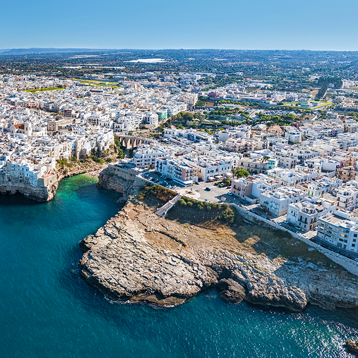
Polignano a Mare (IT)
The Synthetic Site Folder and Site Brief are available for free.
Please register and login to access the Complete Site Folder.
- Synthetic site folder EN | IT
- Site Brief EN | IT
- Site on Google Maps
- Back to map
Data
Polignano a Mare (IT)
Scales L/S
Team composition Architect mandatory
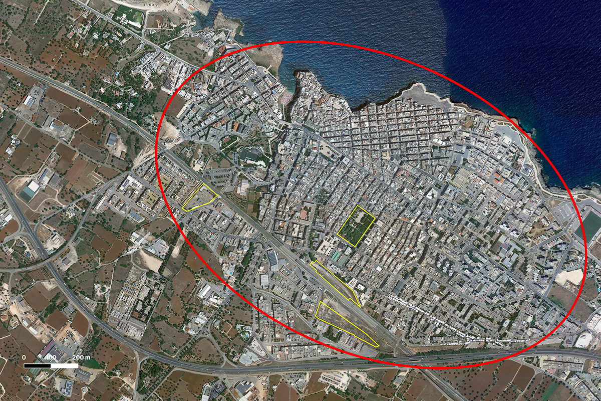
Location Railway Station Area
Population City 17,680 inhabitants
Reflection site 60 ha - Project site 3 ha
Site proposed by City of Modugno
Actors involved City of Polignano a Mare, FS Sistemi Urbani
Owner(s) of the site FS Sistemi Urbani and City of Polignano a Mare
Commission after competition At the national results event, a workshop, together prize-winning teams and stakeholders, will be organised to define the project/process guidelines, in order to define the development and urban transformation of the competition areas. The ideas, typologies and/or approaches developed by the award-winning designers may be the subject of a subsequent project phase in accordance with the regulations of the current procurement code.
More Information
SITE / CONTEXT
Polignano a Mare, a town in Puglia, is located 33 km south of the coast of Bari. It is characterised by the magnificent location of its historic centre, which stands on a rocky outcrop overlooking the Adriatic Sea. Its wealth lies in tourism related to marine activities and agriculture.With an average of 250,000 visitors per year, the FEE, Foundation for Environmental Education, has awarded Polignano a Mare the Blue Flag since 2008 and it was named “Most welcoming city in the world 2023 at the Booking.com Traveller Re- view Awards”.The city hosts the “Red Bull Cliff Diving World Series” every year. Its territory is characterised by a landscape of considerable interest, both naturalistic - with its Lame (Lama Monachile is famous) and sea caves - and histo- rical with its ancient centre and the remains of Roman domination.
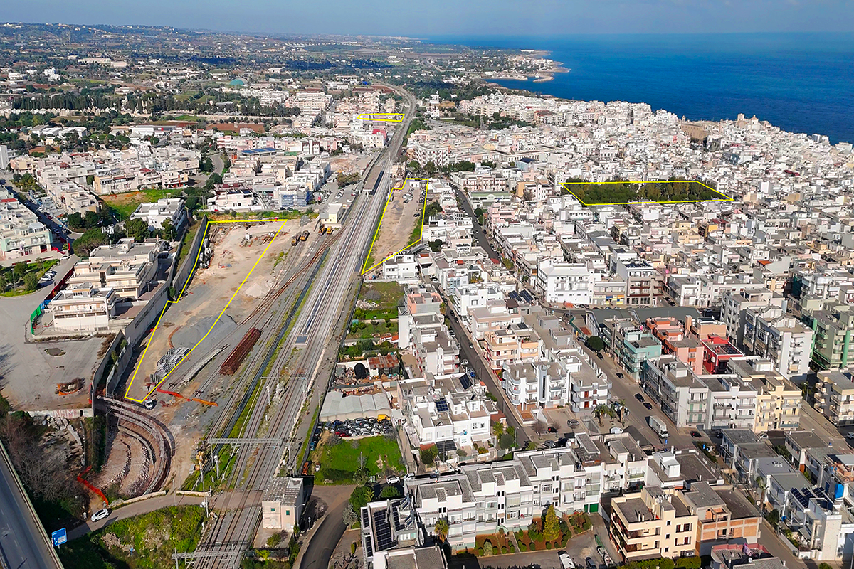
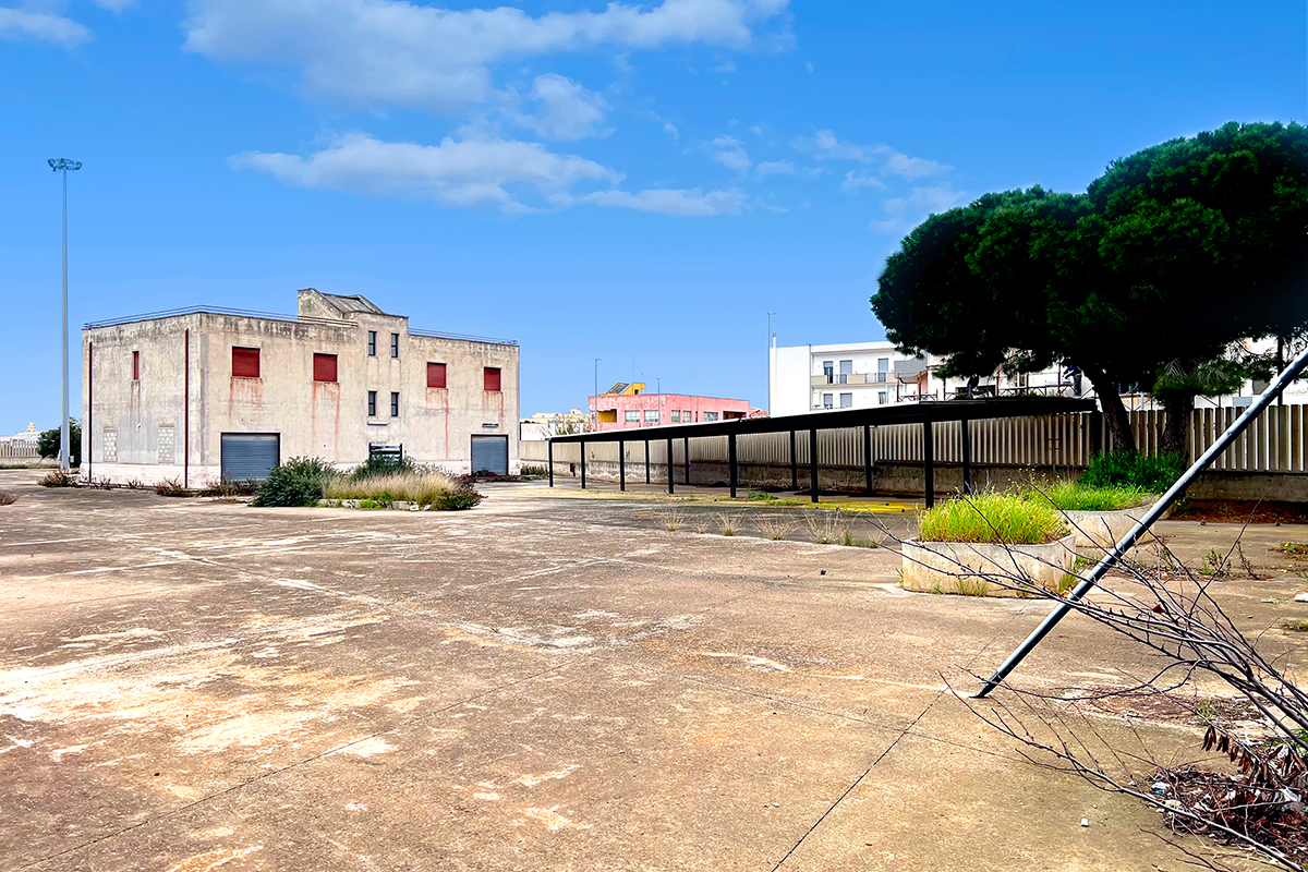
The city is served by two airports (Bari and Brindisi), the railway line, the A14 motorway and the Adriatic SS16. Its tourist attractiveness and urban conformation have stimulated an expansion of the territory along the direction of the coastline and within the SS16 connecting axis. But it has also developed inland beyond the railway line, which represents an important connecting infrastructure both at the metropolitan and tourist level.The crossing of the railway line consists of a number of vehicular subways, which need to be rethought in order to favour the connection of peripheral residential areas with the vital city centre and the sea.
CITY STRATEGIES
The city is promoting the regeneration of the urban system through the Preliminary Planning Document (P.D.R.U.) aimed at improving the urban, housing, socio-economic, environmental and cultural conditions of human settlements and also adopting intervention tools with the involvement of inhabitants and public and private stakeholders.Today the city must respond to new needs of the community that must deal with the activity of tourism by building new social, housing and service dynamics according to the principles of ecological transition, energy saving, inclusiveness. The challenge of EUROPAN is to offer new ideas for these areas with a high re-sourcing capacity.
QUESTIONS TO THE COMPETITORS
The site is defined within the framework of the collaboration between the City of Polignano and FS Sistemi Urbani (leader of the Urban Pole of the Gruppo Ferrovie dello Stato Italiane) for the urban regeneration of a number of compendiums no longer functional for railway operations and of possible future disposal.The areas are located in the area of the central station, a few minutes’ walk from the historic centre and Lama Monachile. An urban transformation is foreseen to create new public and private facilities and to give back to the community the nodal spaces of the city fabric. The redevelopment of the Villa Pinocchio playground is strategic with respect to the station areas, completing the system of connections that already includes the completion of some square improvement projects. The urban fabric of Polignano is strongly oriented towards sustainability due to the ease of creating an high-quality proximity context, by intervening on public spaces and safeguarding the landscape and local resources. Unused areas can respond to the need to combine tourist attractiveness, housing mix and services with attention to connections with urban and landscape systems. In accordance with the regional landscape plan of the Puglia Region, the project must safeguard the natural, morphological and historical-cultural characteristics of the landscape; ensure soil permeability and promote renaturalisa- tion processes, as well as introducing new functions to serve the community and local productivity.
Questions on the site
The DWG doesn't show the pathway that leads down to Lama Monachile (north-west of project site 1 - Lepore). Can we get the data on this path, also regarding the height in comparison to the site?
There are no specific sections of the Lama Monachile. However, they can be obtained from the dwg as the elevations of the contour lines are indicated considering the sea level as 0.
Is it possible to get DWG/DXF-sections for the 4 sites?
The DWG file contains contour lines with elevations. Please note that the project areas are all flat, and the elevation differences are indicated in the DWG plan
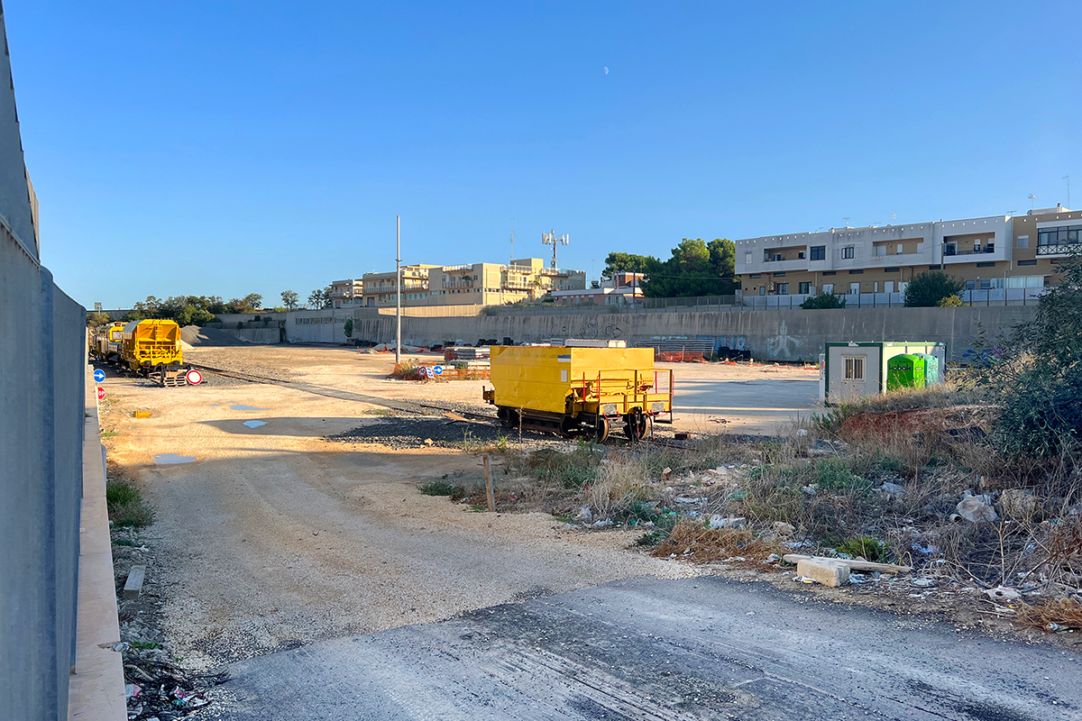
Would it be possible to use or consider as part of our proposal the space adjacent to the northern part of plot 3. Marconi along the railway?
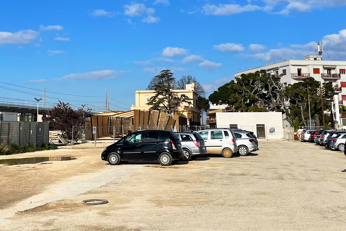
If by adjacent space you mean the area currently used as a parking lot, you can consider it. However, the part of the lot occupied by the tracks and the small building cannot be considered, as it is an operational area for the railway company and will remain in use. You can find a clarifying image in the folder '0-New_Docs_after_Launch'."
Is there a sketch or a plan showing the possible road connection of plot 2. Trieste to Via Antonio Ardito?
As we have already indicated in the previous answers, we insert an example image (see folder 0-New_Docs_after_Launch). It is not mandatory to answer this topic as it is a suggestion indicated by the City.
Dear Europan Team, Could you please confirm the ownership (public or private) of parcels 1357, 1358, and 12971 in the Trieste area, and of parcel 12902/2122, which would be needed for a possible access to Via Antonio Ardito? Thank you! Best regards, Suzdar Dogan Dafina Fazliu
The areas are private, but the possibility of using a strip to create the road, that connects with Via Kennedy near the former road worker’s house, could be considered.
The shape of project site area 3 changes between the documents: it has one shape in IT-POLIGNANO-PS-M15.pdf and a different one in IT-POLIGNANO-PS-M10.pdf (inside the Project_Site folder). Which is the correct shape to be considered for the proposal?
The correct shape is that of the IT-Polignano-PS-M10 file. The M15 file refers only to the cadastral parcels and indicated in blue is the road under construction. In any case in the folder "0-New_Docs_after_Launch" you will find the file with the updated cadastral layout "IT-POLIGNANO-PS-M15-upd.pdf"
It is not clear if the proposal should, or could, also include solutions for residential use. Could you please clarify if residential uses could be proposed?
On the Via Lepore site, one of the main functions is residential, so it is strongly recommended to propose ideas for housing, including innovative and experimental types.
Regarding the project site area 3, it is not clear if the compulsory distance (D.P.R. 753/1980) has to be observed for the operational railtracks (next to the project site), and if so, if that distance is already considered by the boundary of the project site area 3 or if it has to be observed inside the project site area. Could you please clarify?
The distance must be respected within the indicated project site area.
Is it possible to define solutions for the mobility network outside of the project site areas as part of the general strategy?
Yes, it's possible
Is it compulsory to consider the projects provided for the FS station square and the car park in Via G. Marconi?
As for the project on the station square, it is already in the executive phase, so it must be considered as existing and the new design should connect to it. Regarding the parking area on Via Marconi, it is a proposal from the Municipality aimed at reducing traffic pressure in the city center, but the participants are free to propose alternative solutions.
Good morning, is it possible to consider the vacant lot on Via Kennedy near the Casa Cantoniera and level crossing as a connection point between the two project areas? The documents don't clearly indicate where the administration refers to an area between private lots for a possible connection. Could you clarify?
Yes, you understood correctly. Even though the areas are private, you could consider using a strip of them to create the road that connects to via Kennedy near the former road worker’s house.
Per la progettazione dobbiamo tenere conto delle NTE di Rete Ferroviaria Italiana e delle altre normative che regolano la progettazione in prossimità o a contatto delle infrastrutture ferroviarie (i.e. DPR 753/1980)? Should the project consider the NTE of the Ferrovie dello Stato and other rules on the constraints around the railway infrastructure (i.e. DPR 753/1980)?
As indicated in the design brief, Presidential Decree 753/1980 must be taken into account with reference to the minimum distances to be respected.
E’ possibile ampliare il progetto oltre i limiti fisici del concorso? Is it possible to expand the project beyond the physical limits of the competition?
The proposals include interventions in the four areas and allow the freedom to propose project strategies also within the strategic area or at a territorial scale, based on your ideas. However, the project in the four areas cannot be made dependent on interventions outside the perimeters of the strategic area, as this could hinder its feasibility.
This site is connected to the following theme
Re-sourcing from natural elements How to design processes and projects for the revaluation of landscapes that focus on the interdependencies and eco-dependencies of resources (natural, cultural, productive) and the territory? The regeneration of landscapes can become a mediation tool between residential areas, facilities, and obsolete infrastructures and territories undergoing transformation (even at risk) as a result of the effects of climate change. Is an invitation to think at the resources of the area in a regenerative way to support a healthier environment for humans and non-humans?
Regenerating Landscapes
Specific documents
Questions on the site
You have to be connected –and therefore registered– to be able to ask a question.
Fr. 16 May 2025
Deadline for submitting questions
Fr. 30 May 2025
Deadline for answers
Before submitting a question, make sure it does not already appear in the FAQ.
Please ask questions on sites in the Sites section.
Please ask questions on rules in the Rules section.
If your question does not receive any answer in 10 days, check the FAQ to make sure the answer does not appear under another label or email the secretariat concerned by the question (national secretariat for the sites, European secretariat for the rules).