Santa Pola (ES)
The Synthetic Site Folder and Site Brief are available for free.
Please register and login to access the Complete Site Folder.
- Synthetic site folder EN | ES
- Site Brief EN | ES
- Site on Google Maps
- Back to map
Data
SANTA POLA (ES)
Scales L/S
Team composition Architect mandatory
Location Ensanche de Levante/Santa Pola
Population 37,816 inhabitants
Reflection site 5,831 ha - Project site 24,5 m2
Site proposed by Valencia Regional Government + Santa Pola City Council
Actors involved State, Regional and Local administrations + private
Owner(s) of the site Santa Pola Municipality, State administration (DPMT)
Commission after competition Special Plan Project. Urbanisation Project and Health and Safety Study. Works management of the Urbanisation Pro- ject and the Health and Safety Study. For the follow-up and implementation of the project, it is necessary for practical purposes to have two teams that cooperate simultaneously: the international winner team and a local (municipal) team, also with the capacity to make proposals.
More Information
SITE / CONTEXT
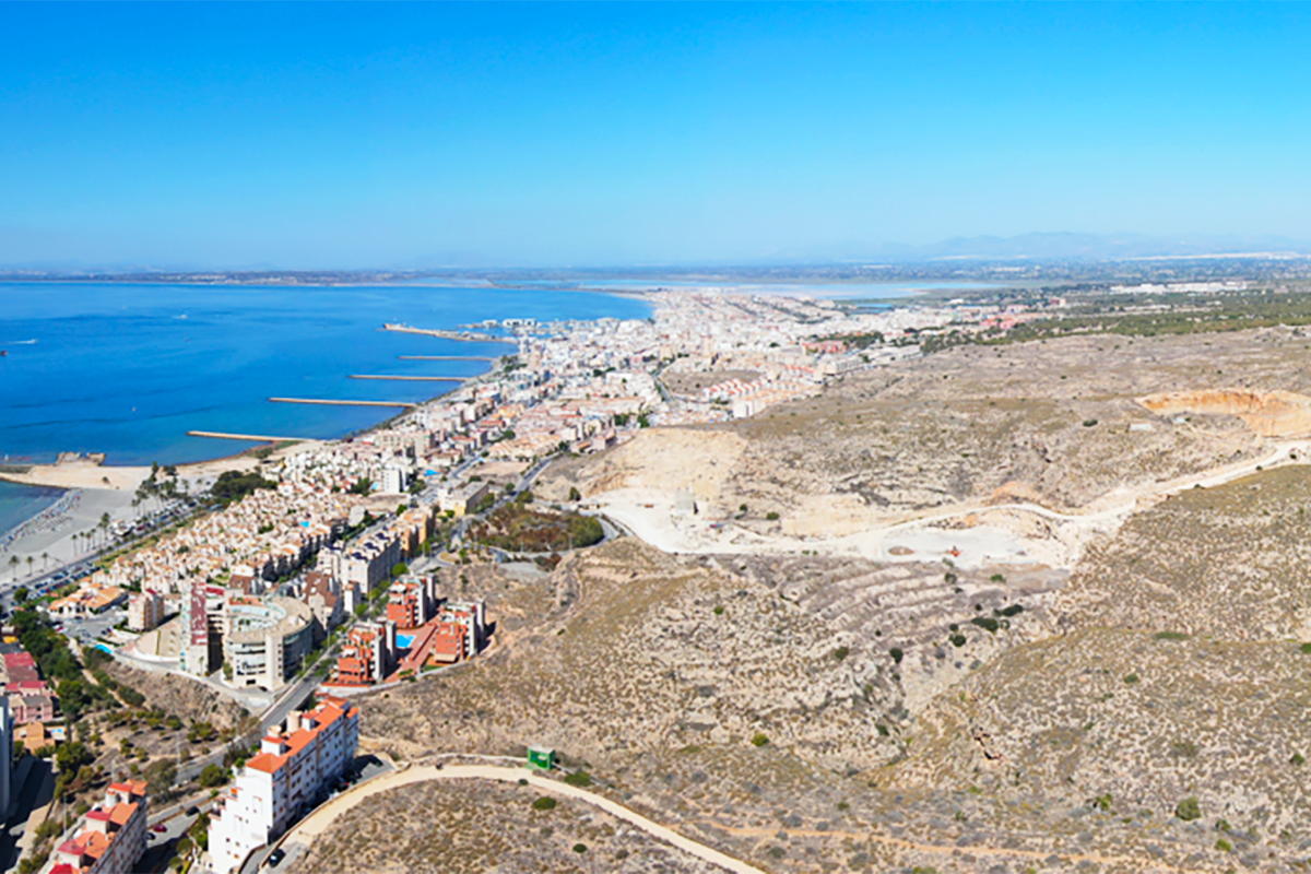
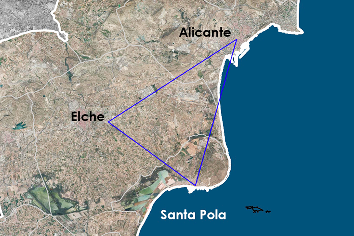
Santa Pola is a tourist municipality on the southeast coast of Spain, located between two centres of activity: Alicante, the capital of the province, and Elche, the second city in terms of population, and immediately next to the international airport. The Alicante-Elche metropolitan area, where the Alicante-Elche-Santa Pola triangle is located, comprises 20 municipalities, with 900,000 inhabitants (2023). It has experienced strong urban expansion and population growth in recent decades.
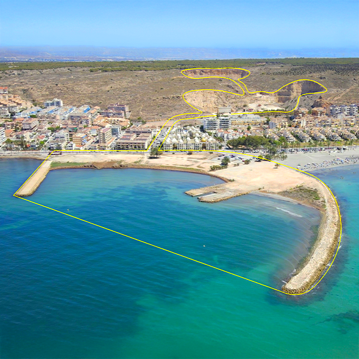
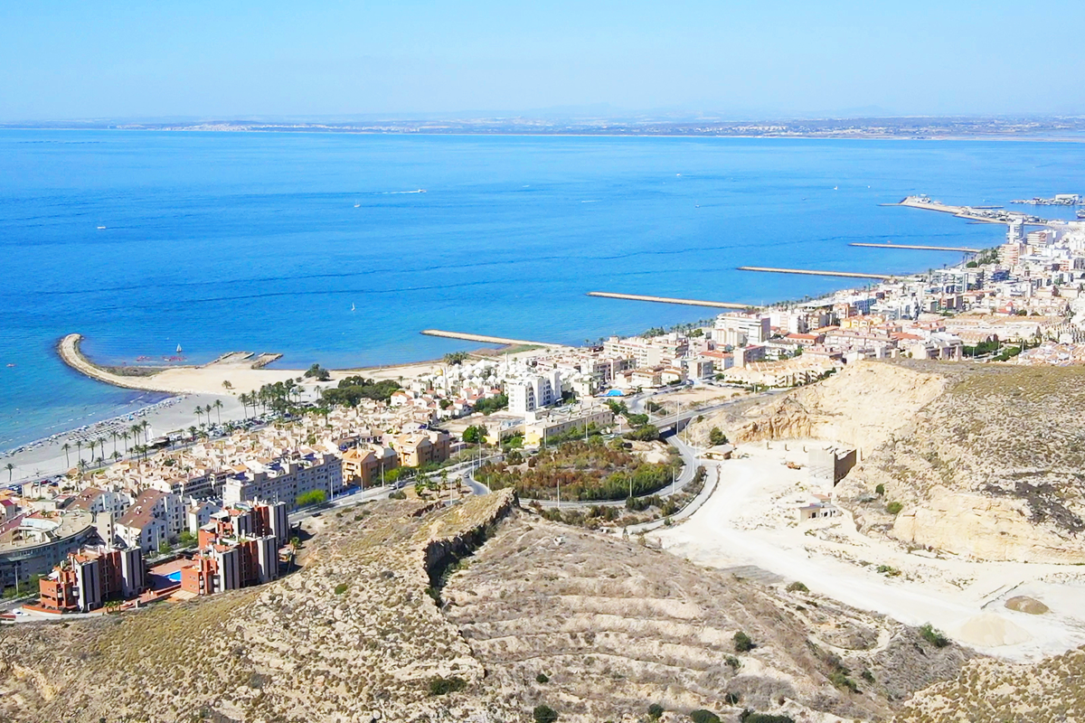
Santa Pola has a long coastline. It was and still is a fishing village, but tourism is now its main source of income. The floating population increases fivefold in summer. The site is located in the privileged area of the municipality; the ‘Ensanche de Levante’: an urban development parallel to the coast, with soils of different classification and use.
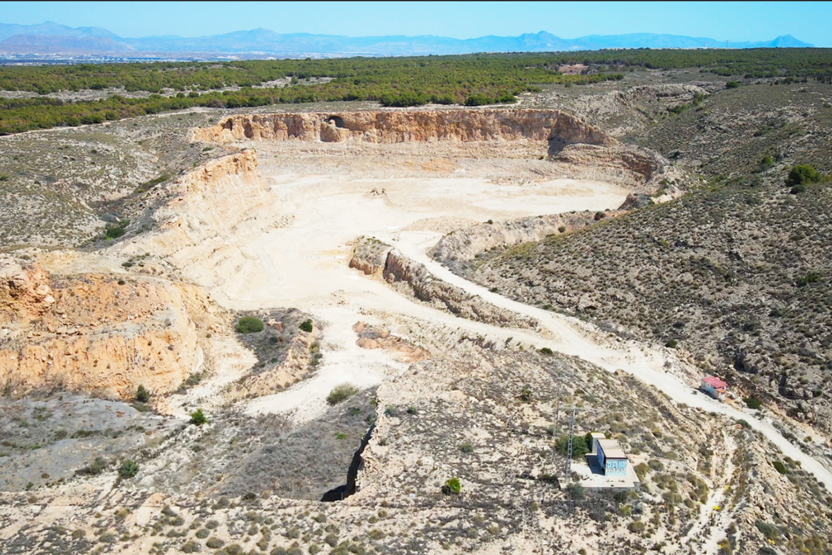
The project area has its historical origin (1923): in the quarry from which the material for the breakwater of the dyke of the port of Torrevieja, a neighbouring town, was extracted. Specifically, in the breakwater of the stone jetty and in the sloping plane that connected the quarry and the jetty by means of a railway track. When the Torrevieja project was completed, the quarry breakwater, which was an auxiliary and provisional work, was not removed.
After the Civil War (1946), two dry docks and shipyards were built in the shelter of the breakwater, popularly known as the engineers' breakwater, to serve the town's important fishing fleet (still the largest in the Spanish Mediterranean today).
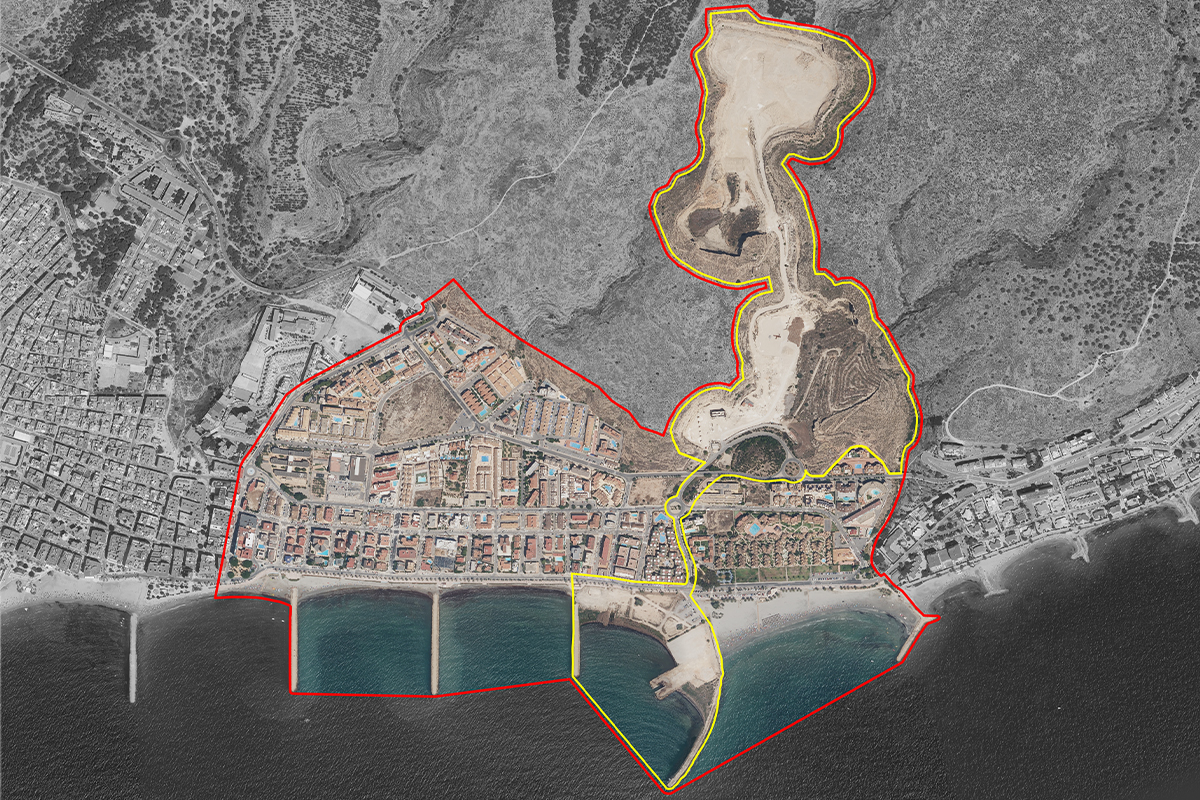
The project site therefore comprises:
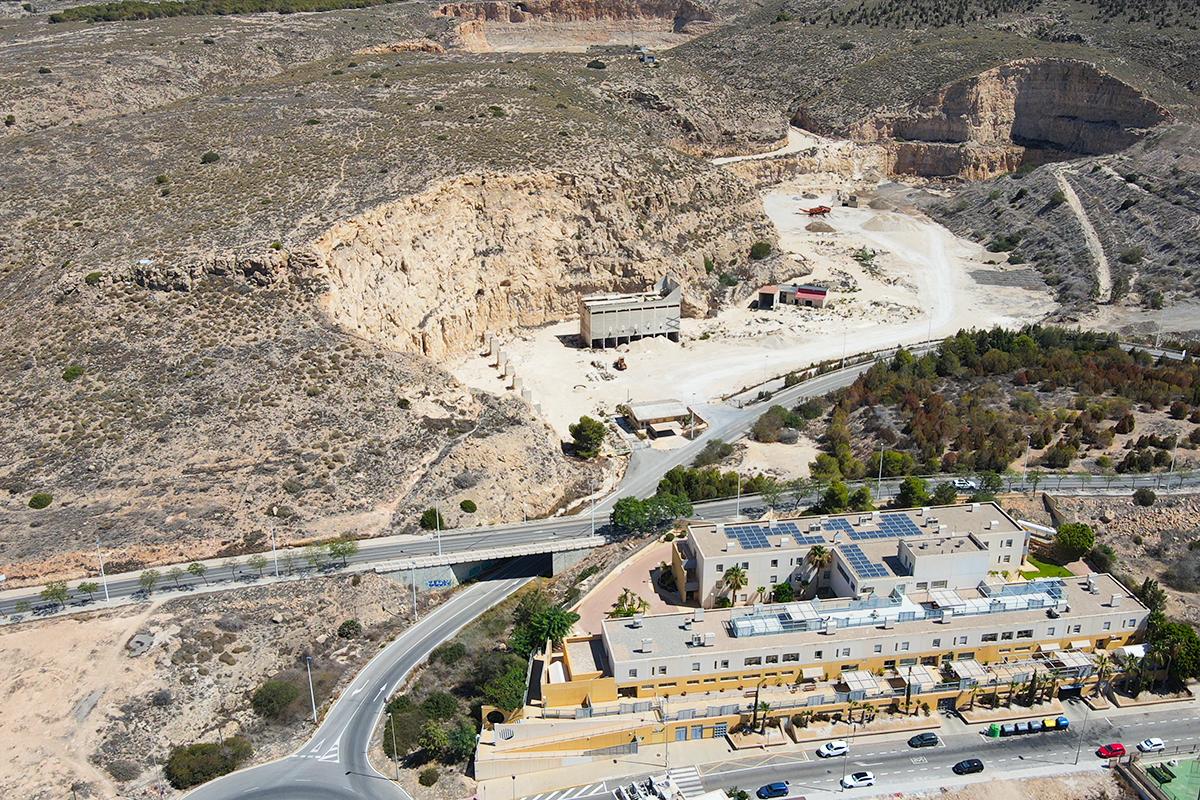
1.- The quarry, nowadays, in disuse, which has left large slopes and cuttings.
2.- On the old sloping ground: some blocks of urban land and housing, all of them crossed by infrastructures at different levels.
3.- And, in the first line, the Varadero beach, which housed the dry dock and the warehouses of the two shipyards that have now been demolished.
QUESTIONS TO THE COMPETITORS
This space, which has become an urban void, needs to be regenerated. But would it be possible to use this need as a driving force for regeneration?
Would it be enough to regenerate the over-exploited space and remove the old warehouses in order to restore the centrality, the previous use, to cover the sloping ground and leave an empty space where there were warehouses to repair the boats? Or would it be better to take advantage of the urban void for new activities?
Environmental studies consider the Varadero to be ideal for the practice of nautical sports. Behind the Varadero, the Quarry (Cantera), currently Non-urbanisable land (Suelo No Urbanizable), is a magnificent enclave: a window to the sea; but there are the limitations of planning.
Should the proposals follow the planning or should the planning be modified by the proposals, we firmly believe that the territory and its complexity should guide the planning.
Is it spatial planning, administrations, location or uses that can make sense again?
Is it possible to shape the empty space and endow it with memory?
How can we take advantage of the new generations' ways of inhabiting and using their leisure time?
Questions on the site
I would like to know what kind of stone or mineral was extracted from the quarry. I have not been able to find that information in the brief. Would you kindly enlighten me?
High quality limestone, gravel and sand.
Dear sir or madam, sorry, but I have a problem understanding the topography of the site, this is due to the contour lines not having the corresponding height written. Could you please tell me what is the height different between curves in the 1:2000 drawings? Thanks in advance Yours, Javier
Dear team, in response to your queries we you can find in “new docs after launch” a map with the height lines so that you can click on them and have an exact number on each. We hope that this will answer your questions.
Is it possible to build new buildings in the ex VATASA area? in the city plan there is no indication about it
Generally speaking, it is not possible to build a new premise in the same space, because it is in the coastal area of influence, but it was part of a harbour in the past, and we claim to recover this vocation. If it were a harbour area it would be possible to have an emblematic building, but it should be very justified on the whole. Although we need new ideas the truth is that it may be difficult as it depends on the state administration. This same answer would apply for an underground building on the waterfront, although it may be a little bit easier. To sum up, it would be possible to design any of those ideas ( the building or the underground construction on the waterfront), even if it would mean greater complexity in the processing of the Special Plan that we need to approve, because we do not want to spoil or throw away any interesting ideas that could be a key for the development and regeneration of this area.
Is it possible to build new structures or services underground on the waterfront?
Generally speaking, it is not possible to build a new premise in the coastal area of influence, but it was part of a harbour in the past, and we claim to recover this vocation. If it were a harbour area it would be possible to have an emblematic building, but it should be very justified on the whole. Although we need new ideas the truth is that it may be difficult as it depends on the state administration. This same answer would apply for an underground building on the waterfront, although it may be a little bit easier. To sum up, it would be possible to design any of those ideas ( the building or the underground construction on the waterfront), even if it would mean greater complexity in the processing of the Special Plan that we need to approve, because we do not want to spoil or throw away any interesting ideas that could be a key for the development and regeneration of this area.
Could we have more information about the main building at the entrance of the Cantera area? Is there any prediction for it?
There is nothing at all. It was the Cantera office.
Existen restos de material extraído de la propia cantera que esten almacenados en el lugar?
No tenemos constancia de la existencia de restos de material extraído. De haberlos no sería en cantidad significativa.
Is it possible to have a plan of the concessions that are present nowadays in the litoral area and have information about when are they going to finish?
Is the quarry currently freely accessible to the public? If so, is it often visited?
The quarry, owned by the municipality, is currently not open to public use. It is a fenced, unguarded area.
Is the quarry safe? Are the walls stable, or is there sediment flow?
The quarry itself is not unsafe for the extraction activity for which it was intended. There is no specific evidence of rockfalls. However, with regard to potential new uses, the need to stabilize some slopes cannot be ruled out a priori.
Could you please provide older ortofotos or plans of the town? I’m interested in the connection between urban development and the local industries/economy. Alternatively, could you recommend an archive where such documents can be found?
There is an IDE of the Valencian Community where you can find and download among other interesting layers of geographic information, a viewer with aerial photos from 1956. We send you the link
https://idev.gva.es/es web of the IDE
https://visor.gva.es/visor/ Viewer of the IDE
just on the right part of the screen it says “ortofotos i imatges” and you can click and choose the picture. Once you have opened the viewer you must write Santa Pola, because if not you are viewing the total Valencian community.
Since it is not possible for everybody to come to the site visit, could the organization together with the city council add some extra pictures from the site visit of the 16th of may?
Yes, we will.
Good afternoon, in the general development plan that you have provided us with, there is an area in pink that is defined as ‘cantil affection’. could you explain to us what this means? Buenas tardes, en el plan general de ordenación que nos habéis proporcionado aparece una área en rosa que viene definida como "afección cantil". nos podríais explicar que significa?
We have a big urbanization on the top of the hill “Monte de Santa Pola” Santa Pola Cape Mountain called “Gran Alacant”. There are lots of cliffs on the edges of this urban area. We draw the red area to keep the first 20 m from the edge of the cliff clean of buildings and other constructions, so that when you have a walk along the protected beach on the east side of the cost, further the urban area, you cant see any building from there. In other words it is a big temptationfor builders to build houses and swimming pools just at the edge of the cliffs in order to have the best views from the house, but if they do so, citizens have the worst views from outside.
Tenemos una gran urbanización en la cima del Monte de Santa Pola, también conocido como Gran Alacant. Hay numerosos acantilados en los límites de esta zona urbana. Dibujamos la zona roja para mantener los primeros 20 m desde el borde del acantilado limpios de edificios y otras construcciones, de modo que al pasear por la playa protegida en el lado este de la costa, más allá del casco urbano, no se vea ningún edificio desde allí. En otras palabras, es una gran tentación para los constructores construir casas y piscinas justo al borde de los acantilados para tener las mejores vistas desde la casa, pero si lo hacen, los ciudadanos tienen las peores vistas desde el exterior.
This site is connected to the following theme
Re-sourcing from natural elements How to design processes and projects for the revaluation of landscapes that focus on the interdependencies and eco-dependencies of resources (natural, cultural, productive) and the territory? The regeneration of landscapes can become a mediation tool between residential areas, facilities, and obsolete infrastructures and territories undergoing transformation (even at risk) as a result of the effects of climate change. Is an invitation to think at the resources of the area in a regenerative way to support a healthier environment for humans and non-humans?
Regenerating Landscapes
Specific documents
Questions on the site
You have to be connected –and therefore registered– to be able to ask a question.
Fr. 16 May 2025
Deadline for submitting questions
Fr. 30 May 2025
Deadline for answers
Before submitting a question, make sure it does not already appear in the FAQ.
Please ask questions on sites in the Sites section.
Please ask questions on rules in the Rules section.
If your question does not receive any answer in 10 days, check the FAQ to make sure the answer does not appear under another label or email the secretariat concerned by the question (national secretariat for the sites, European secretariat for the rules).