Turku (FI)
The Synthetic Site Folder and Site Brief are available for free.
Please register and login to access the Complete Site Folder.
- Synthetic site folder EN
- Site Brief EN
- Site on Google Maps
- Back to map
Data
Turku (FI)
Scales S/S
Team composition Architect non mandatory
Location Vähäheikkilä,Turku
Population Turku 206,000 inhabitants /Vähäheikkilä 1,100 inhabitants
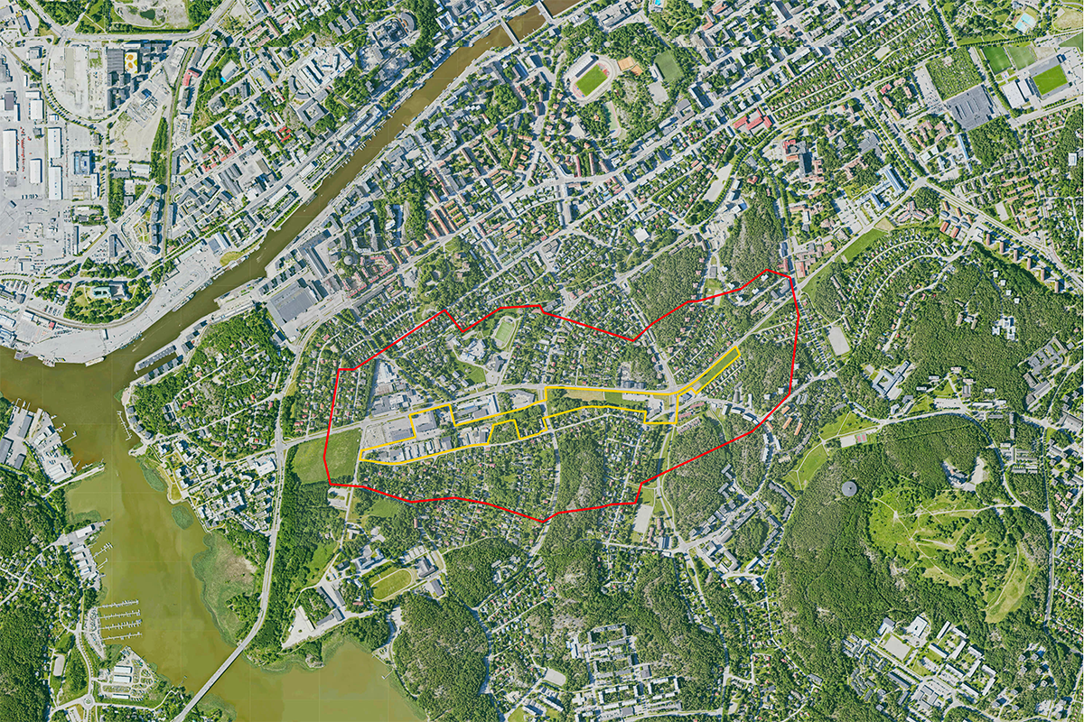
Reflection site 103 ha - Project site 13 ha
Site proposed by City of Turku
Actors involved City of Turku, private partners
Owner(s) of the site City of Turku, private partners
Commission after competition The jury will provide recommendations on further actions based on the competition results, while the City of Turku will make the final decisions regarding follow-up work and its content.The intention of the City of Turku is to negotiate about commissioning the author(s) of the winning proposal(s) at the level of detailed planning and / or landscape design.
More Information
SITE / CONTEXT
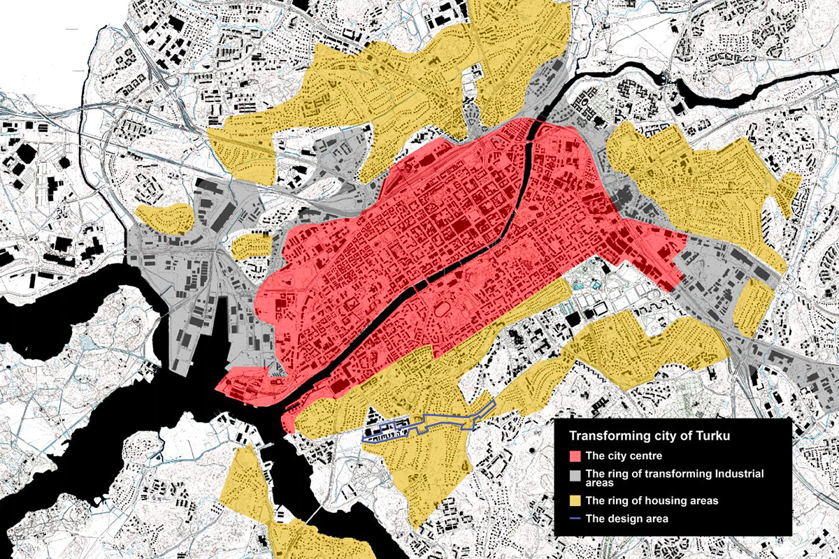
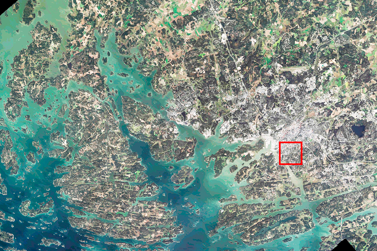
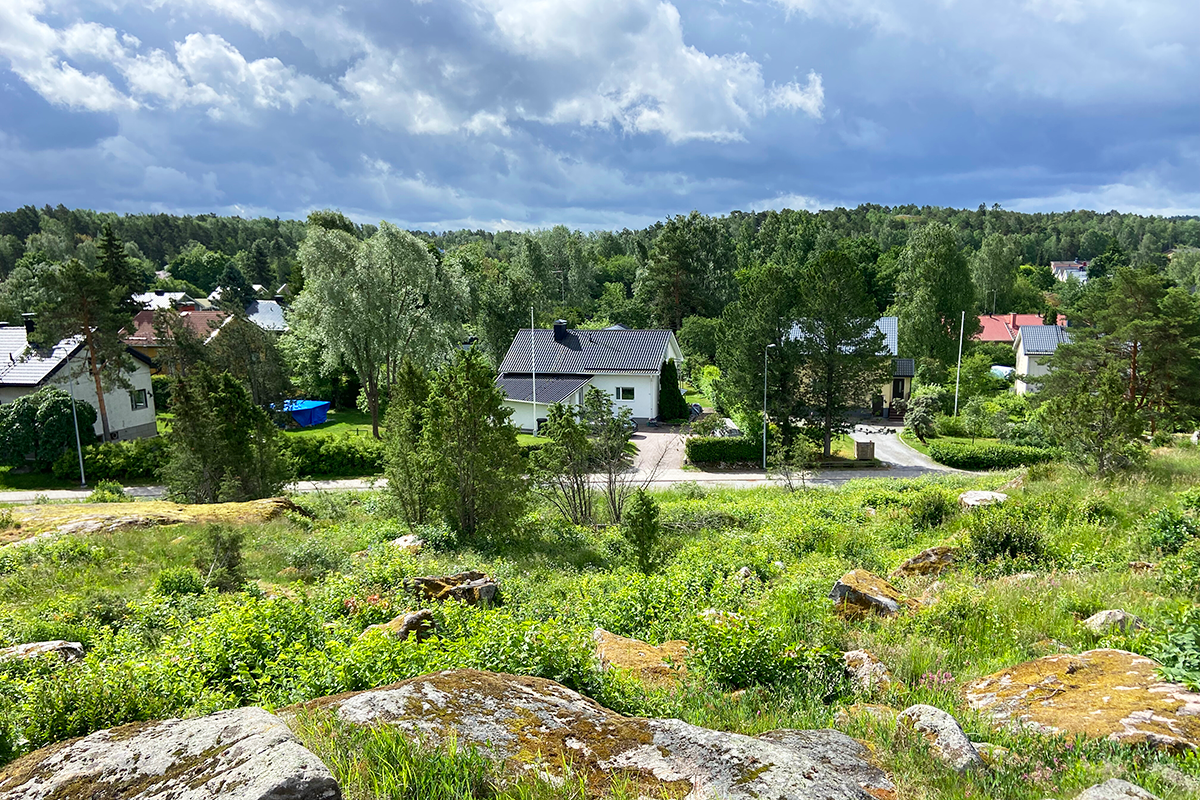
Turku’s flat landscape is punctuated by the Aura River and rocky hills. From the river’s mouth, long views open up to the unique archipelago that starts just outside the city. The 40,000 islands and islets on the Archipelago Sea have an impact in the region’s high natural diversity.
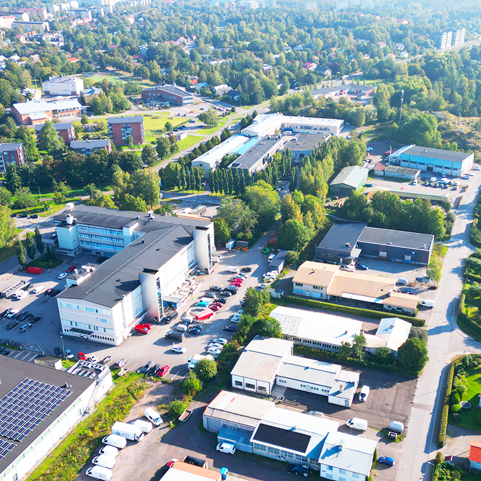
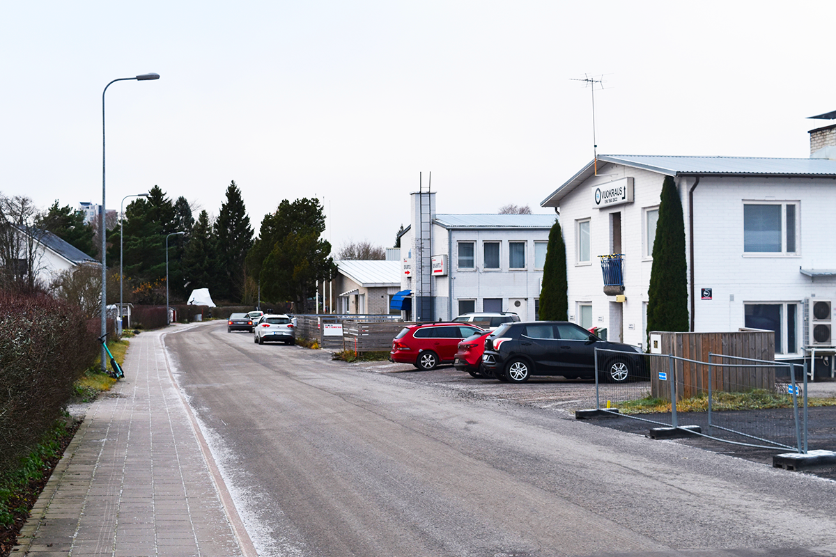
The competition site is located south of Turku city centre, reasonably close to the Aura River and the sea.The environment of the competition area is varied in terms of land uses and urban structure. Around the neighbourhood there are mainly detached houses built in the first half of the 20th century. Similar types of detached house neighbourhood are located in several parts around theTurku city centre.As the city grows, the development and infill of these areas is a topical issue in Turku’s urban planning.The Europan 18 competition for the Vähäheikkilä site seeks examples of possible approaches to the future development of these areas.
Between the housing estates, a strip of undeveloped land and small industrial buildings remains in the competition site, partly unplanned and unfinished in appearance. Among small industrial plots there is a green area, once reserved for a potential road which is no longer needed. The competition area lacks a common identity that would link its parts into a whole.
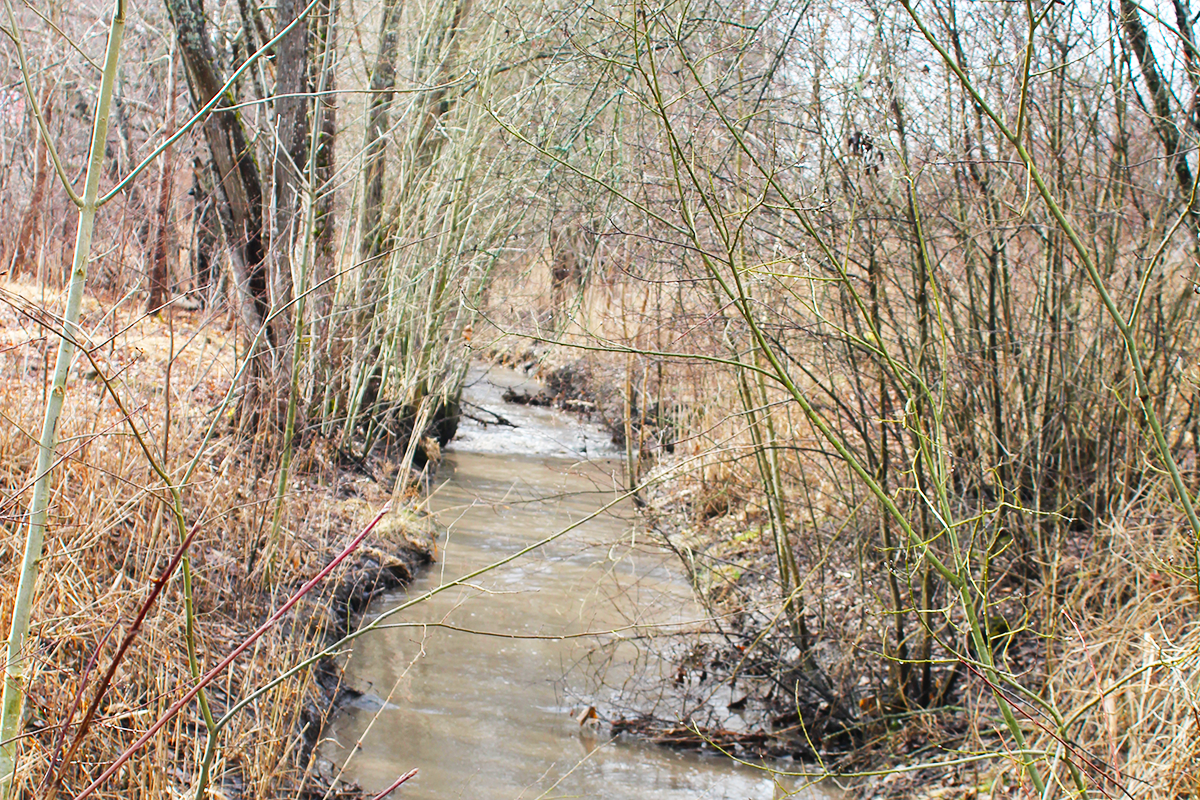
In the project site, the height of the terrain varies mainly quite gently. However, next to the site there are also two steep rocky hills that rise like islands from the low clay terrain. The landscape is mainly semi-open with some wooded areas.The competition site serves as an important stormwater route. The urban stream runs at present mostly in an underground pipe. It collects water from an extensive catchment area, but the risk of flooding is high. Better stormwater detention and controlled management is essential to allow infill development in other parts of the catchment area. The aim is to restore parts of the underground pipe with an open stream and ponds to increase biodiversity and reduce the risk of flooding.
QUESTIONS TO THE COMPETITORS
Transforming the area reserved for an unbuilt street, alongside the small industry plots and adjacent undeveloped wasteland, provides a unique opportunity to create a new central urban space for the entire Vähäheikkilä neighbourhood.The area currently lacks a cohesive urban structure. How can the site be better integrated with the surrounding neighbourhoods and the city centre?
Stormwater management solutions should be a key element of the design of the new public urban spaces.With Turku preparing for climate change, ecological solutions are vital. Urban nature should be qualitatively improved, focusing on increasing biodiversity in greenfield areas and preserving valuable meadows.
The area should be functionally diverse. How can the site balance business, industry, education, and mixed housing in a sustainable manner? What form will new housing and services take in this small-scale neighborhood? What is the future of the industrial halls in terms of resources and mixed-use potential? Can some of these halls be preserved or the structures reused and repurposed? The goal is not high-density development but rather an emphasis on enhancing the site’s overall quality.
Questions on the site
Hi, can we get access to all existing building plans of the Turku site? Floorplans, sections and elevations.
In the Complete Site Folder, you will find floor plans, elevations, and a section of the office/business building at Vähäheikkiläntie 52, which will be most likely preserved. The smaller buildings, however, are represented only by exterior photographs and a separate summary of their current uses, as their future remains open for consideration.
Competitors are not expected to provide detailed designs for the reuse of the buildings but should instead propose potential uses—whether for the existing buildings or the plots they occupy— at an urban planning and design level.
There are a lot of existing parking spaces in the project area that serve businesses outside the project area. How should we approach the design of these? Should we preserve the amount of all parking lots but relocate them somewhere else? Or can we reduce the amount of them and if so how much?
As a starting point, parking spaces should be arranged within each property’s own lot or, alternatively, in (a) shared, centralised parking solution(s). Competitors do not need to account for the parking needs of properties located outside the project area.
The instructions in 7.2 specify exact scales, particularly for the 1:1500 landscape plan and the 1:800 landscape plan and section. Is it permissible to slightly adjust these scales for better functionality? For example, we believe the 1:800 plan and section would be easier to read at 1:1000, and the 1:1500 plan at 1:2000.
We find that when the drawings are printed for the evaluation, their readability would be much compromised if the scales were reduced. Therefore, even if the specified scales are slightly unconventional, we kindly ask competitors to adhere to them to ensure clarity and facilitate a fair comparison of proposals.
Recordings of the Site Visit on the project site and the walk back after the visit (on the reflection area) are added to the Complete Site Folder > New Docs After Launch
Is the Stormwater Study (Ramboll Finland Oy 2024) available somewhere to read? It was mentioned on the Site Brief on pages 13 and 22. We tried to search it from Ramboll's and Turku's sites with no results.
Unfortunately, the Stormwater Study (Ramboll Finland Oy 2024) is available only in Finnish and is not accessible to the competitors. However, the main guidelines and findings from the study have been summarised in the site brief. The diagram on page 22 is also based on the study. More detailed area reservations, drawn according to the stormwater study, can be found in the Complete Site Folder (FI-TURKU-SS-M1.dwg).Please note that it’s not necessary to copy these directly—competitors may propose alternative locations for the channels and basins.
On page 22 there is a mention that "No structures of buildings or roads shall be placed in the vicinity of the slopes". However, can there be smaller additional paths close to the slopes?
Yes, smaller additional paths—such as park walkways—can be placed on the slope of the stormwater channel. However, all areas near the channel must tolerate occasional wetting. In particular, if the slope is gentle, a path can function well. Building close to a steep slope is more risky, as the stability of the soft clay soil is poor and the edges may collapse easily.
On page 22 there is said that "At the eastern part of the planning area, a water supply and sewage line runs immediately adjacent to the existing open ditch (Varsoja). Aside from landscaping, no major interventions should be made on the adjacent slope". Where is this adjacent slope part exactly? Is it the south slope of the Varsoja?
The pipelines run under the slope, which is situated on the southern side of the Varsoja Ditch.
Can we propose, with a good reason, a narrower street width for Vähäheikkiläntie, or is the street width of 27 m absolute?
The proposed dimensioning of Vähäheikkiläntie is based on the long-term goal of accommodating high-quality pedestrian and cycling infrastructure on both sides of the street. Competitors may with well-justified reasoning propose a narrower cross-section for Vähäheikkiläntie. At the very start of the street the existing street width is 25 meters which should be considered the minimum. (It is hoped that the Hirvensalo Bridge project will progress in the future, reducing the need to allocate additional car lanes on Vähäheikkiläntie at the expense of pedestrian and cycling facilities.
The cross-section between Uittamontie and Ispoisten puistotie roads is to be cut from north to south (parallel to those roads), or east to west (perpendicular to those roads?)
The cross section 1:800 is to be presented in a north–south direction, located at a relevant point between Uittamontie and Ispoisten puistotie roads. The purpose of the drawing is to illustrate how the proposed development on the project site integrates with the surrounding urban fabric on the northern and southern sides of the project area.
Discrepancies between the E18 Competition Rules (section 4.4 "Items to Submit") and the Site Brief
Some slight contradictions and ambiguities have been identified between the E18 Competition Rules (section 4.4 "Items to Submit") and the Site Brief for Turku. Please follow all instructions provided in the Competition Rules, which the Site Brief refers to and which take precedence over the Briefs in case of contradiction.
– According to the Competition Rules, competitors are required to submit 3 images in PDF format for communication purposes, not 2 images in JPG format as stated in the Site Briefs. (Note: these images for communication don't need to show any new content, they’re some of the drawings and images made for the A1 panels.)
– The illustrated text presenting the project ideas should be a maximum of 4 pages, instead of 6. The text for communication purposes should be about 800 characters long (spaces included, to be typed in during submission).
Please also note:
– The Team Form and the Declaration of Authorship, Partnership, and Acceptance of the Competition Rules are available online in each team’s personal area and must be filled out and signed. Also pictures of the ID’s of the team associates and contributors showing that you’re under 40 years old are required.
– As the competition is anonymous no names shall be revealed on the panels or other competition material.
– We recommend adhering to the maximum panel file size of 20 MB as stated in the Rules. You can upload your documents in parts as they become ready if needed you can always update them until the submission closes.
This site is connected to the following theme
Re-sourcing from natural elements In context of global warming, to live and to re-dynamize inhabited milieus thanks to water is a strong driver for re-sourcing ; crossing the challenge to adapt to risks (flooding, marine submersion, coastline withdrawal, drought…) and to restore ecological milieus to improve quality of life, health and joy of every day.
Dealing with Water
Specific documents
Questions on the site
You have to be connected –and therefore registered– to be able to ask a question.
Fr. 16 May 2025
Deadline for submitting questions
Fr. 30 May 2025
Deadline for answers
Before submitting a question, make sure it does not already appear in the FAQ.
Please ask questions on sites in the Sites section.
Please ask questions on rules in the Rules section.
If your question does not receive any answer in 10 days, check the FAQ to make sure the answer does not appear under another label or email the secretariat concerned by the question (national secretariat for the sites, European secretariat for the rules).