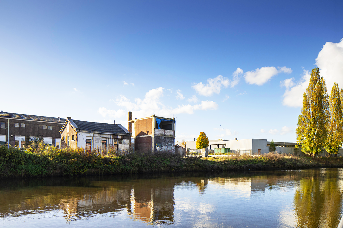
Amersfoort-Kop van Isselt (NL)
The Synthetic Site Folder and Site Brief are available for free.
Please register and login to access the Complete Site Folder.
- Synthetic site folder EN
- Site Brief EN
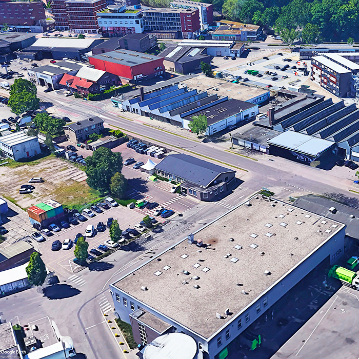
- Site on Google Maps
- Back to map
Data
Amersfoort-Kop van Isselt (NL)
Scales L/S
Team composition Architect non mandatory
Location Kop van Isselt, Amers- foort
Population 160,000 inhabitants / 285,000 inhabitants Metro
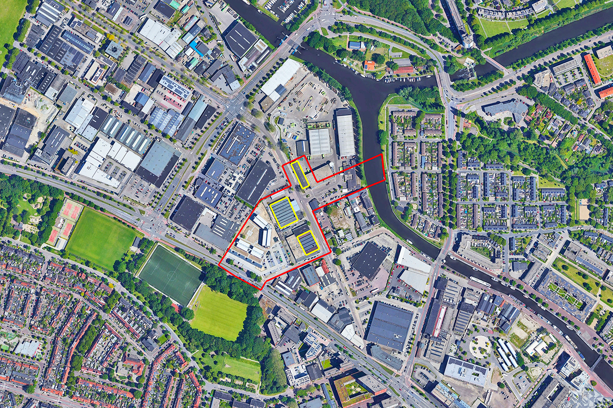
Reflection site 3,45 ha - Project site 0,32 ha
Site proposed by Municipality Amersfoort
Actors involved Municipality Amersfoort
Owner(s) of the site Municipality Amersfoort
Commission after competition The Municipality of Amersfoort, in partnership with the owner(s) of industrial heritage structures, are committed to realize the central public space. Currently, the building(s) are for temporary use, the owner(s) are keen to advance the concepts and typologies developed through the competition into a viable and profitable project, with the aim of realizing it. The Municipality also envisions the possibility of commissioning further design studies for the central public space, to explore opportunities for thoughtful urban development.
More Information
SITE / CONTEXT
Amersfoort is reimagining its urban landscape to create vibrant, sustainable and inclusive growth. The transformation of the Kop van Isselt area presents an opportunity to reintegrate industrial legacy into a dynamic district. This mixed-use development envisions 2,000 to 3,000 new residences, creative industries, and public amenities, fostering a lively and sustainable urban ecosystem. Propose bold yet practical solutions for the comprehensive transformation of this area by repurposing industrial heritage structures, integrating diverse mixed-use programs, enhancing ecological connectivity. The goals is to create a distinctive central urban area with a renewed identity, creating vibrant public spaces that reflect adaptability and sustainability while addressing local and urban-scale needs.
QUESTIONS TO THE COMPETITORS
Adaptive Reuse of Industrial Heritage
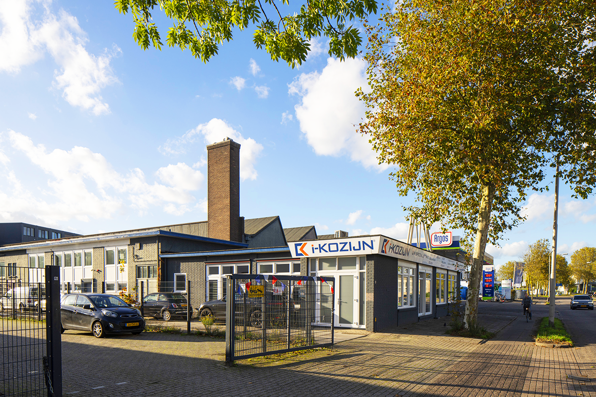
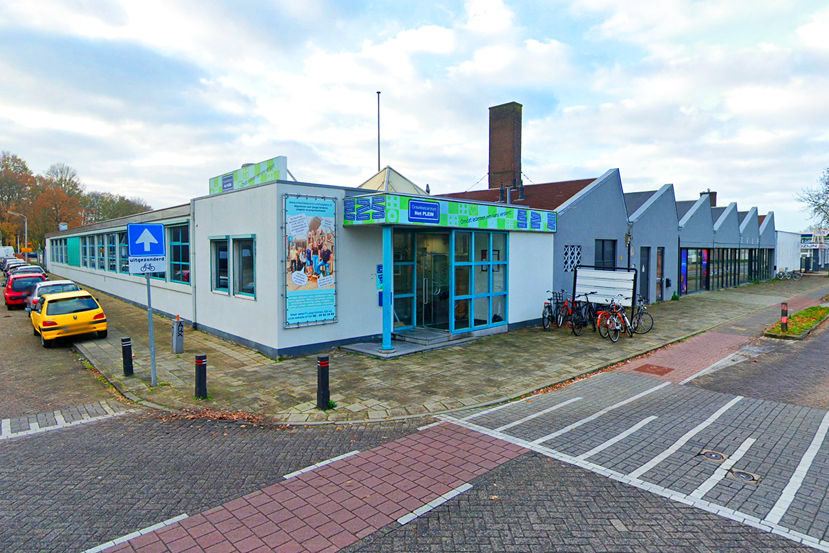
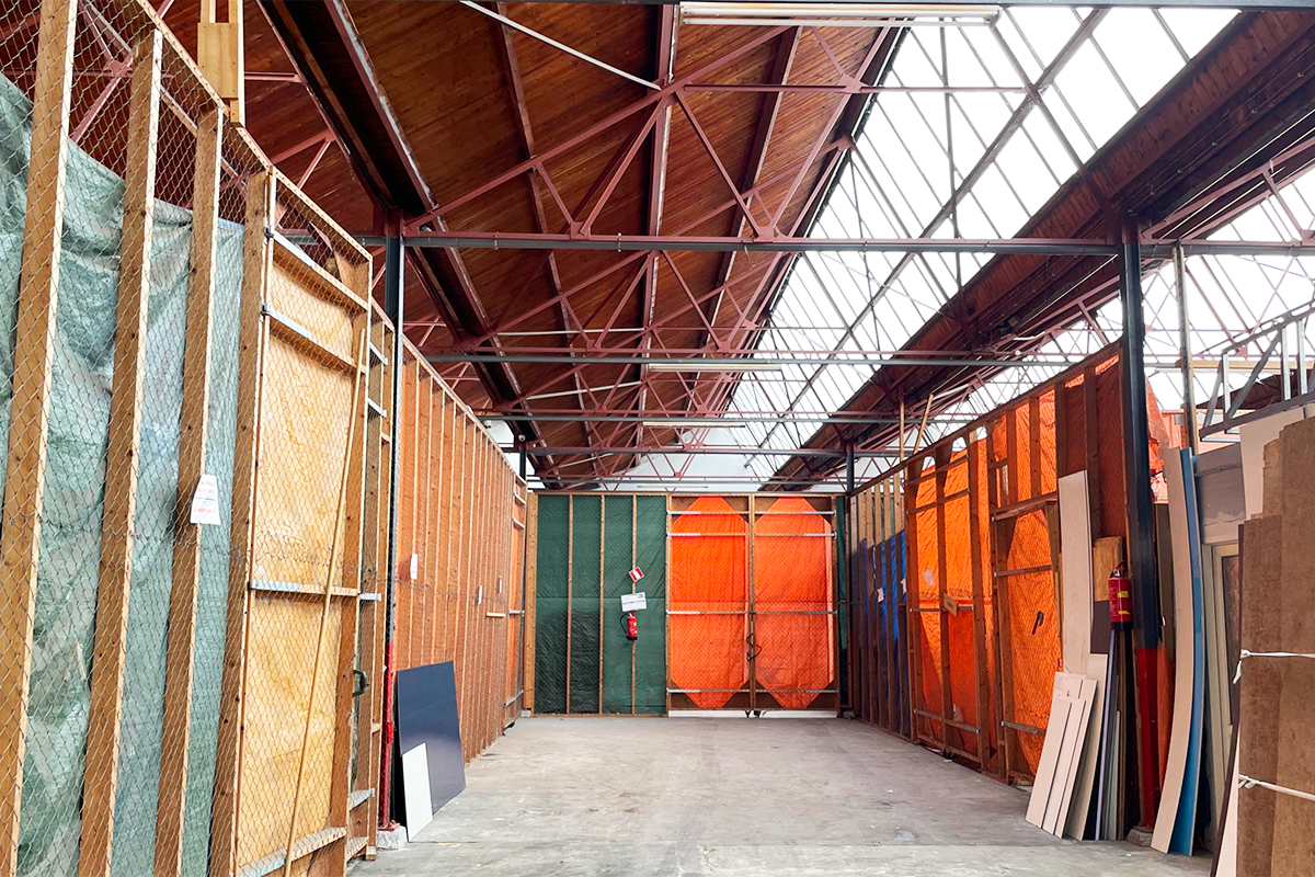
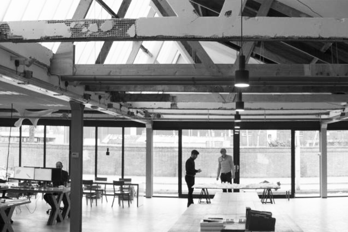
The historic industrial buildings at the heart of Kop van Isselt are earmarked for adaptive reuse, becoming vibrant hubs for creative industries, public functions, and recreational activities. These structures will anchor the district, blending their architectural heritage with modern, functional designs to shape the identity of the central public space. A comprehensive building envelope strategy should explore how these buildings can be transformed to unlock their full potential. This may include lateral expansions, vertical additions, or innovative architectural interventions that preserve their historical significance. These strategies must demonstrate financial viability by harmonizing innovative design with pragmatic solutions that ensure long-term success.
Eempark as the Green Heart
Eempark is designed to be central to the district, connecting neighbourhoods through leisure spaces for sports, picnics, and pathways for cycling and walking. It will strengthen biodiversity by linking the green belt (Groengordel) from the Soesterkwartier to the Eem, forming a ecological corridor that boosts biodiversity and connectivity. Propose a visionary conceptual design for the central public space that integrates urban vibrancy with green infrastructure. Incorporate a terraced landscape for effective flood mitigation and highlight enhanced accessibility to the river Eem to foster both recreational and ecological opportunities. Bicycle and pedestrian pathways must ensure seamless connections to the central buildings.
New and interesting ways of living
Transform the existing single-floor buildings (all buildings within the reflection area) to accommodate approximately 160 housing units, contributing 16,500 m2GFA of residential space (excluding parking). Landmark NeNaFa and fabriek van Van der Meiden can rise to 14-16 floors but ROVA shed is classified as a municipal monument, the interior is also protected. The change must be done in conjunction with the monumental values. New building volumes can be added on top, alongside, or through the existing halls, all while preserving and celebrating their industrial character. This integration of residential spaces should foster a lively community atmosphere by introducing new and interesting ways of living through innovative typologies that redefine urban lifestyles.
Creative Incubator and Community
To meet the growing demand for creative and health-oriented spaces, the proposed building envelopes (all buildings within the reflection area) will feature a creative incubator ±2,500 m2 will provide much-needed maker spaces, fostering innovation and collaboration. Additionally, health centre ±1,000 m2 will deliver a pharmacy (160 m2), general practitioner (410 m2), physiotherapy (100 m2), dentist (250 m2) and midwifery practice (40 m2). The new building must exemplify circular design, renewable energy, biodiversity at its core.
Questions on the site
The building block incl.NeNaFa hall varies across documents. The axo in the site brief shows a free-standing tower(p.47), while the plan drawing(p.38) shows a hall as part of an urban block. The heritage analysis suggests a high-rise and block behind the hall. Is the block envelope predefined or is its design part of the competition task?
1. We are aware that the representation of the building block, including the NeNaFa hall, varies across different documents. For clarification, page 47 of the brief provides the most relevant summary of the intended spatial framework.
2. The volumes illustrated on page 47 are indicative only—they represent the maximum allowed volume, not a fixed design. You are free to interpret and position the new volumes creatively: they can sit on top of, next to, or intersectingthe existing hall. The form is also flexible—they do not need to follow the square geometry shown in the axonometric diagram.
3. The shape and layout of the park should follow the red boundary line as defined in the brief, but its internal configuration and design of the park is part of the competition scope.
Is it possible to provide technical drawings / surveys of the buildings on Project Site? There are very little documentation provided and 2d drawings in site's folder pdf's (NeNaFa waardestelling for instance) are too low resolution to read dimensions and use effectively for modelling.
Fortunately we found plans for theNijverheidsweg_Noord_35 as pdf , but not available in a digital (CAD) format. please do downloaed it from the folder named "0-New_Docs_after_Launch"
The Protected Warehouse in Nijverheidsweg-Noord, 35 is different on every document received and none of them is matching the measures that we could extract from Google Maps. Being a Protected monument, is it possible to have some clearer drawing in order to better conceived a future use? Thanks in advance
1. We are aware that the representation of the building block, including the NeNaFa hall, varies across different documents. For clarification, page 47 of the brief provides the most relevant summary of the intended spatial framework.
2. The volumes illustrated on page 47 are indicative only—they represent the maximum allowed volume, not a fixed design. You are free to interpret and position the new volumes creatively: they can sit on top of, next to, or intersectingthe existing hall. The form is also flexible—they do not need to follow the square geometry shown in the axonometric diagram.
3. The shape and layout of the park should follow the red boundary line as defined in the brief, but its internal configuration and design of the park is part of the competition scope.
Reding the many useful documents of the "PS-f reading list", there are many different Masterplan that regulate the area surrounding the study area of our project site. In order to better design our proposal considering an already existing Masterplan, which one should we consider as the final? Thanks in advance
1. We are aware that the representation of the building block, including the NeNaFa hall, varies across different documents. For clarification, page 47 of the brief provides the most relevant summary of the intended spatial framework.
2. The volumes illustrated on page 47 are indicative only—they represent the maximum allowed volume, not a fixed design. You are free to interpret and position the new volumes creatively: they can sit on top of, next to, or intersectingthe existing hall. The form is also flexible—they do not need to follow the square geometry shown in the axonometric diagram.
3. The shape and layout of the park should follow the red boundary line as defined in the brief, but its internal configuration and design of the park is part of the competition scope.
Hello, I would ask if it's possible to receive a more detailed 3D Model of the buildings and the context of Amersfoort-Kop van Isselt, with also the level curves of the surrounding landscape. Thanks in advance. Arch. Marco Casalena
Unfortunately, we do not have plans in more 3D detail as per your request
Are there any other uses for the surrounding development area besides work, housing and parking, such as a school, kindergarten or public buildings? And if so, where should they be located? Thanks in advance.
All the known information regarding Kop van Isselt plan (beyound the red boundery) is shared in the complite site folder. (E18-CSF-NL-Amersfoort-Kop_van_Isselt/3-Project_Site/PS-f_reading-list')
Regarding the Project Area (yellow areas). Is it mandatory for new buildings to be inside the areas with the yellow outline, or can we think of putting them in other locations as well (e.g., adjacent to historic industrial buildings)?
1. yellow area is to show what volumen must stay, you are allowed to position the new volumes creatively: they can sit on top of, next to, or intersecting the existing hall.
2. The volumes illustrated on page 47 are indicative only—they represent the maximum allowed volume, not a fixed design. You are free to interpret and position the new volumes creatively: they can sit on top of, next to, or intersecting the existing hall. The form is also flexible—they do not need to follow the square geometry shown in the axonometric diagram.
Shall we provide covered/uncovered parking areas (for cars) in the plot?
1. 15 parking spaces for creative incubator/ Health centre, plus 0.4 spaces per dwelling.
2. The 15 spaces required for the creative incubator/ Health centre can be accommodated underground in the new block behind the NeNaFa building. (page 47)
3. The 0.4 spaces per dwelling will be provided within the communal parking structures in the larger masterplan area, so there’s no need to account for them separately.
4. Parking in the red-marked area is not permitted.
For the historical buildings (NeNaFa and Van Der Meiden) located in the plot, are there any indications regarding which part should be kept? Can we demolish the recent additions, while keeping only the shed parts?
1. The characteristic historical building parts, particularly those with triangular roofs, should be preserved, while the newer and modern additions may be demolished.
2. Yes, you demolish the recent additions, while keeping only the shed parts.
The DWG files provided are showing the current condition of the area. Are we supposed to use these ones as base for our drawings or the scenario of the new development of the area (as shown in the latest 3D shared in the new docs after launch)?
1. as shown in the latest 3D shared in the new docs after launch is one of the scenario of the new development of the area. the 3D can be used to understand what kind of volumes can be expected in the sarroundings of our site. the 3d provided is not final as of now!
2. We are aware that the representation of the building block, including the NeNaFa hall, varies across different documents. For clarification, page 47 of the brief provides the most relevant summary of the intended spatial framework.
What is the program to be located in the ROVA building?
ROVA building is classified as a municipal monument, the interior is also protected. The change must be done in conjunction with the monumental values. you are free to propose any function(s) as far as is public/open to all.
Is the bridge connecting the two banks of the Eem part of our design scope?
yes
Is the bridge supposed to be fix or movable (in order to let boats pass)?
Please do consider all aspects passing boats, heights of the two sides etc. we are open to any ideas either fix or movable!
For representation purpose, do we need to use the current state plan shared in DWG? or the new masterplan shared in 3D?
1. for sarrounding to our location you can us the 3d provided.
2. We are aware that the representation of the building block, including the NeNaFa hall, varies across different documents. For clarification, page 47 of the brief provides the most relevant summary of the intended spatial framework.
3. The volumes illustrated on page 47 are indicative only—they represent the maximum allowed volume, not a fixed design. You are free to interpret and position the new volumes creatively: they can sit on top of, next to, or intersectingthe existing hall. The form is also flexible—they do not need to follow the square geometry shown in the axonometric diagram.
4. The shape and layout of the park should follow the red boundary line as defined in the brief, but its internal configuration and design of the park is part of the competition scope.
In the 3D model received from the documents "after the Launch" there are two building near the Amsterdamseweg that are inside of the red boundary line. Are we free to decide what happens to them? (redesign, delete, etc)
1. We are aware that the representation of the building block, including the NeNaFa hall, varies across different documents. For clarification, page 47 of the brief provides the most relevant summary of the intended spatial framework.
2. The volumes illustrated on page 47 are indicative only—they represent the maximum allowed volume, not a fixed design. You are free to interpret and position the new volumes creatively: they can sit on top of, next to, or intersectingthe existing hall. The form is also flexible—they do not need to follow the square geometry shown in the axonometric diagram.
3. The shape and layout of the park should follow the red boundary line as defined in the brief, but its internal configuration and design of the park is part of the competition scope.
For confirmation only. Do you confirm that the 3D file to be used as main context for our proposal is the one named "les", uploaded on April 20th? In that case, some of the new buildings are occupying part of the park included in the red line.
yes
Regarding the new block, is it possible to move it everywhere inside the plot (ie next to the river) or its location is fixed?
1. As shown on pages 47 and 55, the two should be understood as complementary and representing the same idea. Page 47 indicates that three volumes (blue) are to be added, and the new block should be proposed approximately in the location shown on that page.
2. Total of ±160 housing units spread over (NeNaFa, Van der Meiden and New block) contributing 16,500m2 GFA of residential space (excluding parking) A creative incubator ±2,500 m2 spread over (NeNaFa, Van der Meiden and New block) Health centre ±1,000 m2 spread over (NeNaFa, Van der Meiden and New block)
Page 38 of the brief outlines the proposed phasing plan. Is there a diagram showing the area in relation to the phases? Or do the four phases refer to the image below on the same page? If not, could the organiser indicate which document or page clarifies this? Street names are unclear.
You can find more information in the document 472_sh_OntwikkelkaderKVI, specifically on pages 92 to 95.
P. 47 shows three new volumes for approximately 160 units. However, the competition assignment on p. 55 and the project site boundaries do not include the location of the new block shown on p. 47. Is it therefore possible to add a separate volume outside the project site boundaries (yellow lines) in order to meet the programme requirements?
1. As shown on pages 47 and 55, the two should be understood as complementary and representing the same idea. Page 47 indicates that three volumes (blue) are to be added, and the new block should be proposed approximately in the location shown on that page.
2. Total of ±160 housing units spread over (NeNaFa, Van der Meiden and New block) contributing 16,500m2 GFA of residential space (excluding parking) A creative incubator ±2,500 m2 spread over (NeNaFa, Van der Meiden and New block) Health centre ±1,000 m2 spread over (NeNaFa, Van der Meiden and New block)
We kindly ask you to provide a clear and definitive answer to the following question, which we have previously raised: Will the two buildings located behind the Fabriek van Van der Meiden, and currently extending beyond the red line of our plot in the new masterplan, be kept or removed? Please respond with either "kept" or "removed".
1. We are aware that the representation of the building block, including the NeNaFa hall, varies across different documents. For clarification, page 47 of the brief provides the most relevant summary of the intended spatial framework.
2. please do consider page 47 as leading.
3. removed
Is the third block mandatory or can we avoid it if we manage to reach the surface required?
1. A key strategic advantage of the new (third) block is that it allows for easier integration of underground parking and simplifies the construction process. The design and positioning of the block provide greater flexibility in planning and executing structural elements such as access ramps and foundation systems, leading to improved efficiency during construction.
2. The decision is at your discretion. However, if you believe there is a strong case for making a proposal, please ensure it is supported with clear reasoning and a well-defined set of advantages.
First, regarding the document mentioned in the answers " 472_sh_OntwikkelkaderKVI" where can we find it? We couldn't find it in the reading list.
you should find the documents here: E18-CSF-NL-Amersfoort-Kop_van_Isselt/3-Project_Site/PS-f_reading-list/472_sh_ErfgoedKVI_presentatie.pdf
Second, regarding to spatial framework there is a tiny discrepancy between pg 47(brief) and latest 3D model uploaded (Palmbout). Which one is the most accurate? Do we need to consider to compensate this lost in sqm?
1. We are aware that the representation of the building block, including the NeNaFa hall, varies across different documents. For clarification, page 47 of the brief provides the most relevant summary of the intended spatial framework.
2. please do consider page 47 as leading, you do not need to compensate the m2.
Second, regarding to spatial framework there is a tiny discrepancy between pg 47(brief) and latest 3D model uploaded (Palmbout) in the left bottom corner of pg 47, the two blocks that are cut. Which one is the most accurate? Do we need to consider to compensate this lost of sqm?
1. We are aware that the representation of the building block, including the NeNaFa hall, varies across different documents. For clarification, page 47 of the brief provides the most relevant summary of the intended spatial framework.
2. please do consider page 47 as leading, you do not need to compensate the m2.
The document Kop van Isselt- kaders op een rij.pdf (2021) is missing, could you provide it? The document 472_sh_OntwikkelkaderKVI.pdf is missing, could you provide it?
Sterange, On our end it is in the reading list folder but to be on safe side we have uploaded a copy to the folder ; E18-CSF-NL-Amersfoort-Kop_van_Isselt/0-New_Docs_after_Launch
I am not able to open the 3D file les 2025-19-2--11-47-05.glb, could you please re-upload or save a different file?
1. unfortunately we dot have acess to the original file provider, but the les.klm is the same information this can be opened in google earth
Do there have to be exactly three new added buildings or can more than three buildings be added?
yes three
To what extent should the red and yellow areas differ in the level of detail in our planning?
can you please explain your question in another words? we are unable to understand your question.
In the latest 3D model uploaded, there is a trapezoidal shape volume into the red plot area stepping into part of the park. Can we consider it removed?
yes
This site is connected to the following theme
Re-sourcing from social dynamic A missing layer of urbanity is added on a territory with underlying complexities. In all these large sites, the question is how inhabit them, how to relate to them, how to add a human ecosystem while negotiating the pros and cons of the existing complexity. It may be to reconsider an urban interrupted development, to care wounds left or created by old or new infrastructures; to regenerate sub-standard housing or the damage left behind a brownfield, to reconsider a river or former agricultural fields.
Creating New Urban Relationships
Questions on the site
You have to be connected –and therefore registered– to be able to ask a question.
Fr. 16 May 2025
Deadline for submitting questions
Fr. 30 May 2025
Deadline for answers
Before submitting a question, make sure it does not already appear in the FAQ.
Please ask questions on sites in the Sites section.
Please ask questions on rules in the Rules section.
If your question does not receive any answer in 10 days, check the FAQ to make sure the answer does not appear under another label or email the secretariat concerned by the question (national secretariat for the sites, European secretariat for the rules).