Wien (AT)
Les Dossiers synthétiques et d'enjeux sont disponibles gratuitement.
Merci de vous inscrire et vous connecter pour accéder au Dossier complet de site.
- Dossier synthétique EN
- Dossier d’enjeux EN
- Le site sur Google Maps
- Retour à la carte
Données synthétiques
WIEN (AT)
Scales XL/L
Team representative Architect, urbanist and landscape architect
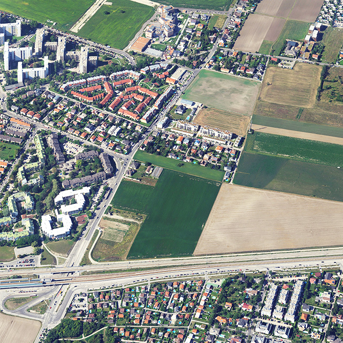
Location Vienna, Heidjöchl
Population 1,9 MIO
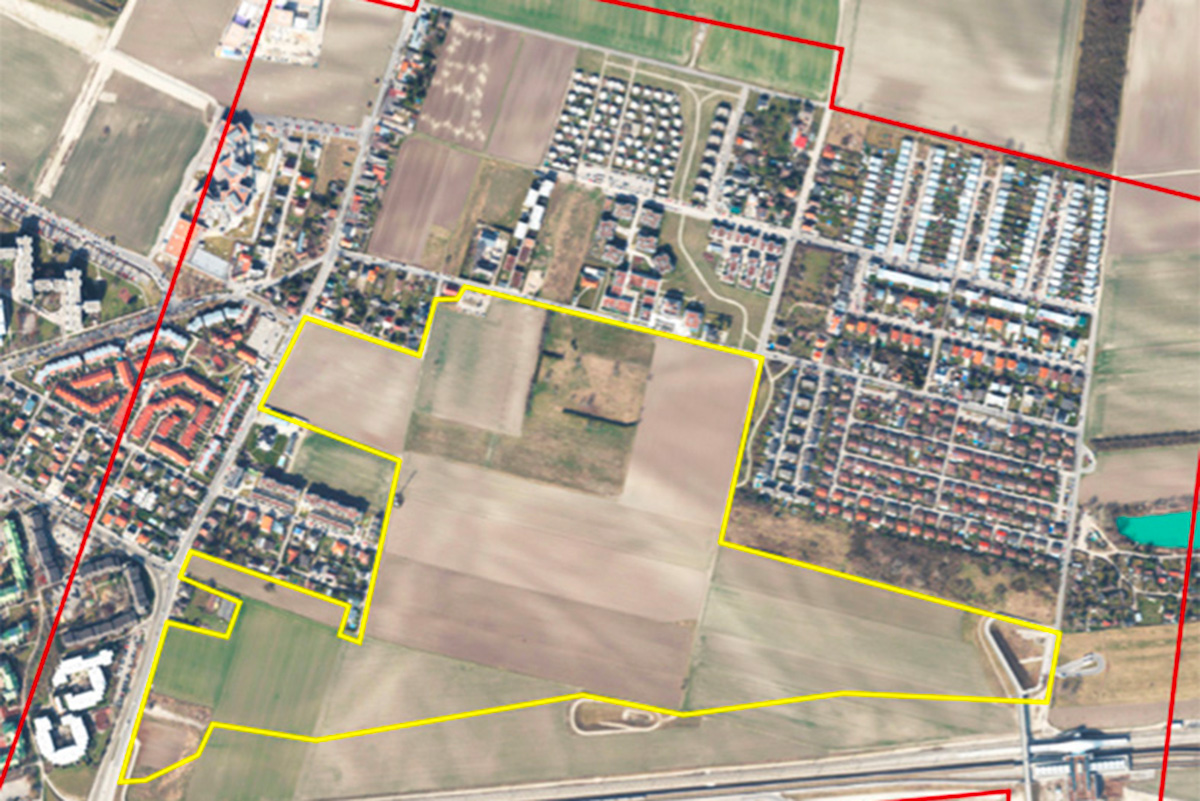
Reflection site 70 ha - Project site 35 ha
Site proposed by City of Vienna
Actors involved City of Vienna,Wohnfonds Wien
Owner(s) of the site Several housing associations & City of Vienna
Commission after competition It is intended to commission the winning team with a process lasting about on year for the creation of an urban planning concept immediately following the competition.
Information complémentaire
Inhabited milieu's challenges
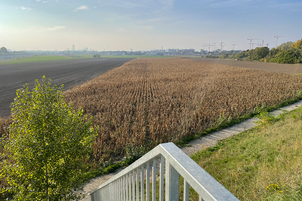
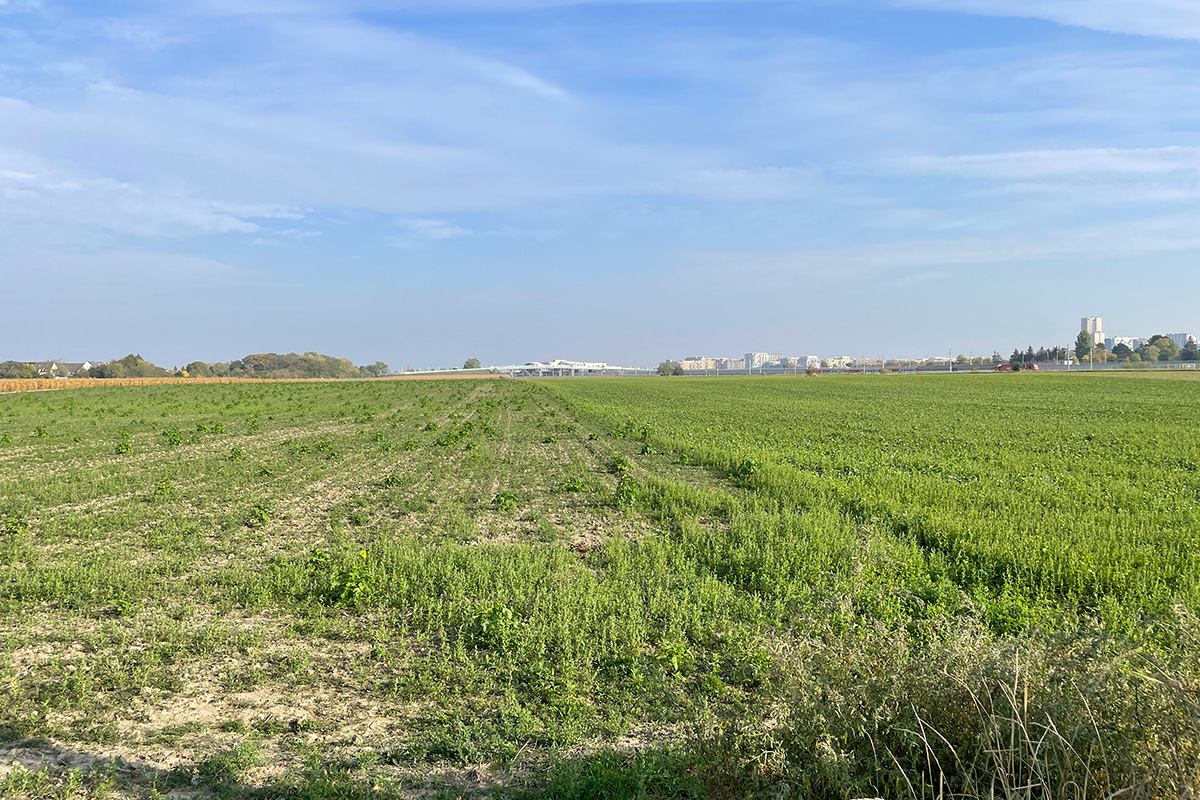
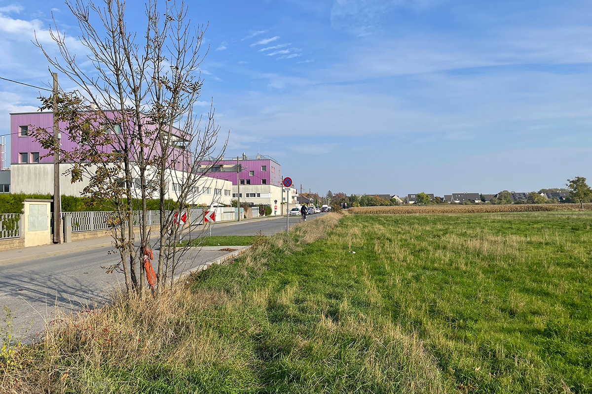
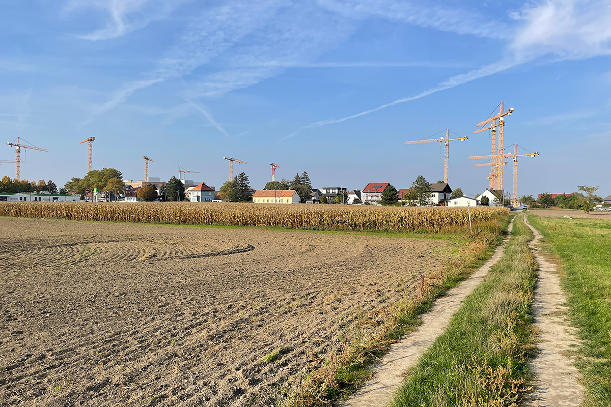
How to think about new, large-scale developments in the present era? Vienna is growing, and fast! The city is currently one of the fastest growing metropolises in the German speaking region. In the next few years the city is expected to surpass the 2 million mark, which causes an increasing demand for housing. Over the past decade, Vienna has made considerable efforts to expand its public infrastructure. Extensions of existing or new metro lines now quickly reach the fringes of the city. Densification along these corridors is a strategy that the city is pursuing. It’s in this context that we find the site «Am Heidjöchl». It is located along the new U2 underground line in Vienna’s 22nd district, Donaustadt. Donaustadt borders on the surrounding countryside and is still partially characterised by agriculture. It has a heterogeneous appearance, with carpets of single-family homes alternating with multi-storey terraced houses and interspersed with individual large blocks of flats. Several parts of Donaustadt are earmarked for new urban development. Famous for its size and in the immediate vicinity of Heidjöchl is «Seestadt Aspern», an ongoing mixed development project for around 40,000 people. Other smaller developments are also in the neighbourhood. Heidjöchl, a long-term strategic area, is the final piece in this comprehensive urban strategy. Local residents value the relaxed atmosphere on the outskirts with lots of green and open spaces and need to use the car more than an average Viennese. Therefore, the project must address existing requirements while proposing an alternative model inclusive and in tune with our planet, where harmful habits can be easily abandoned.
Questions to the competitors
Vienna’s climate guide and the knowledge gained from the developments around the site provided the framework for Heidjöchl. The aim is an urban paradigm shift that places sustainability at its very core. Around 11,000 people will live here in about 4,900 residential units. The basic parameters are already defined: two stops of the underground line, a two-stop tram line, schools and kindergartens, affordable housing and workspace. Density can be increased near the public transport stops, while at the edges a reasonable fit with the existing neighbourhood is required. What is really important, however, is a holistic approach to social inclusion, the presence of green space and an urban foundation for resilient development. There are several questions that need to be addressed: Firstly, how to reconcile the existing with the emerging? Secondly, what can a dense but very green urban quarter look like in this well-connected location? Thirdly, how can the transition between private, semi-private, and public zones be managed, especially on a porous ground floor? Fourthly, how can nature become an integral part of the whole site and be connected to larger green corridors? Finally, how to work with the local climate and expected effects of climate change to ensure an urban fabric fit for future habitation and well-being, conceiving the planet as a shared habitat for humans, animals, and plants?

Questions à propos du site
1. Good afternoon. The webpage of the Wien location seems to be missing a couple of files. The folders (0)-New_Docs_after_Launch and (4)-Brief do not have anything inside. I'm guessing the first one is because the folder is just created to upload new content but I don't know about the Briefing one. Thanks for answering.
You are correct, the folder (0)-New_Docs_after_Launch is currently empty, as no further information has been requested. In case we upload further information, you will find it there. We will inform everybody registered.
The brief is free to download. The download link is part of the page describing the Vienna site. The brief should also be found in the folder (4)-Brief. I have been informed by the administrator that the document is there.
1. The overall site plan doesn´t fit on the layout in the scale of 1-2000. Is it possible to use a different scale in order to include the important connections to the context?
Please use the scale 1:2.500 for the overall site plan.
2. How can we understand the use of the ecological green belt close to Stadtstraße? Is there a bicycle path planned in this area or could we think of one?
The green belt north of Stadtstraße serves as a potential field for ecological compensation measures to mitigate the ecological and acoustic impacts of the Stadtstraße project (see plan AT-WIEN-SS-M6). An accompanying path is planned between Stadtstraße and the ecological compensation area (see plan AT-WIEN-SS-M5). This accompanying path can be used by pedestrians and cyclists.
As stated in the brief this compensation area is not part of the project site, fundamental changes of the plans for this area are not possible. A network of bicycle paths through the entire quarter (project site) should be planned connecting to the existing and planned structures in and around the project site.
3. Currently, there is only a pedestrian bridge crossing the metro and railway in the southeast part of the site. Is there going to be another bridge for the tram in the future? Why wasn't it integrated with the already existing one?
The map of the planned tram line, that includes the planned situation with the bridges, can be found in the attachment “AT-WIEN-SS-M3” and “AT-WIEN-SS-M3a”. A new bridge for the tram line (and busses) is going to be built right next to the existing pedestrian and bicycle bridge. The concept is intended to have connections wherever needed.
4. What are the ownership conditions of the adjacent properties? Does the City of Vienna still have adjacent land reserves? If so, where and in what size?
All the properties within the project site can be regarded as available for urban development, no consideration has to be given to the property ownership situation. The adjacent properties within the reflection site are already built-up or designated for other uses (e.g. green spaces) as stated in the brief. If the question aims at where are further urban development areas in the surroundings, so please refer to AT-WIEN-SS-M7 (all areas marked red). The areas north of Lackenjöchlgasse have been defined as “green reserve”, which means that they shall only be considered for urban development if special situations arise, like if the existing urban development areas cannot provide enough space for the growing city any more, a situation that is not foreseeable at the moment.
5. Three out of seven members of the local jury are provided by the city of Vienna. How is sufficient neutrality in this commission ensured, given the controversial development of a four lane road on the reflection site?
The decision to build a four-lane road (Stadtstraße) has been taken by the City of Vienna. The road is currently under construction. It is a non-negotiable infrastructural element and no concern of the jury.
6. Why is the Lobautunnel portrayed as a given in the brief, although the project was cancelled? Can up-to-date plan material be made available showing the planned course of the Stadtstrasse with its end point in the Seestadt Aspern?
On page 33 of the brief the so-called Stadtstraße (city road/ dual-carriage-way) is mentioned. It is stated that this road will connect the A23 south-eastern tangent highway with the S1 ring road in the future. The Stadtstraße is partially routed underground, with a tunnel immediately south-west of the project site (Hausfeldstraße corner Ostbahnbegleitstraße). This tunnel is already under construction and has nothing to do with the Lobau tunnel project under the danube river, which is located in a distance of more than 4km to the southeast of the project site.
Plan material showing the planned course of the Stadtstraße including the tunnel is available (AT-WIEN-SS-M5 and AT-WIEN-PS-M1) and the planned course of the Stadtstrasse is shown in the recently provided 3D-Data.
7. Is the required area for the kindergarten part of the education campus or the housing? Contradictory information is given in the brief.
It is planned to build an educational campus on the project site. This campus includes one kindergarten. In addition to this kindergarten, two more kindergartens are to be established in the project site, preferably integrated in buildings with a different use in the upper floors (e.g. housing). These two kindergartens are not mentioned in the point “ground area” in the box because of the planned integration in buildings mainly dedicated to housing or other uses. The gross floor area of those kindergartens should be 2,200m2 each (+1,500m2 open space).
It is very important to position these facilities strategically (see brief p. 40 and 41).
8. Can a 3D model of the volumes of the Seestadt Aspern Masterplan be provided?
In order to obtain a 3D model, you are required to complete a consent form. The team representative need to sign the form and send it via email to Europan Austria at office@europan.at. This procedure is in place to maintain the anonymity of the competition. We will retain the signed forms until the conclusion of the competition, at which point they will be handed over to the City of Vienna.
All participants who registered before June 6, 2023, have already been contacted via email. If you registered after that date, you can find the Declaration of Consent form in the "0-New_Docs_after_Launch" folder.
9. What are the required level of detail and the level of representation concerning the floor plans (regarding living units, public functions at the anchor points and specially the educational and care facilities)?
There should be schematic representations, in particular of the proposed functions (school, busy ground floor zone, kindergarten, living on the ground floor, etc.) integrated in the plans.
10. Do the 3,3 ha for educational campus include open and green spaces?
Yes, the ground area of 1.8 ha for the educational campus and the 1.5 ha for the federal school include open and green spaces. Despite that, the educational campus of the City of Vienna should be planned directly adjacent to the public park.
11. Are the ramps/hills and bridges for the future access to Stadtstaße and the tram line to the west of the Aspern Nord station subjects of design?
The ramp of the tram line west of Aspern Nord station is already planned and will be built until 2025 together with the tram line (AT-WIEN-SS-M3 and -M3a; “straßenbündiger Gleiskörper mit Busbenützung” means tracks will be integrated into a street that will also be used by buses). It means that the ramp itself cannot be changed. However, this ramp is intended to be flanked by buildings on the south-western side and to become a sloping inner-city street in the future (see section QS A10 in AT-WIEN-SS-M4). The urbanistic structure of these buildings, potentially facing to the street formed by the ramp, is subject of design. The projected ramp connecting to Seestadt (and Stadtstraße) on the project site is subject of design (blue arrow in AT-WIEN-PS-M1). Also this ramp is intended to be flanked by buildings and to become a sloping inner-city street. The pedestrian bridge that should be designed in connection to the green-belt west of Seestadt should also be subject of accessible design and thus can lead to the task of integrating a ramp into the cityscape (green arrow in AT-WIEN-PS-M1).
12. Is it possible to remodel the Meyrederbrücke or to change the ramp leading to the bridge, or to merge the bridge with the future tramway bridge?
See question 3 and 11.
13. What is the expected level of detail for the interventions in the Reflection Site (areas outside of the Project Site)? Are proposals for the implementation of new built structures being expected in the Reflection Site?
No proposals for the implementation of new built structures in the Reflection Site are expected with few exceptions mentioned in the brief. For example the design of a pedestrian bridge over the traffic-belt connecting to the green belt west of Seestadt.
14. Are there any plans available for the future buildings to the south of Aspern Nord station?
The planning process for this area is not yet at the level of design of the single building. Despite that, there is an urban development concept for this area (AT-WIEN-SS-S2 and provided 3D-Data).
15. Is the area to the south of Aspern Nord station also to be included in the design proposal of that focal point (since it is a part of the Reflection Site)?
No plans should be proposed for the area south of the Aspern Nord station; the existing Masterplan for that area should be considered. See questions 13 and 14.
16. Are the two retention basins (one is part of the Project Site - next to Mayrederbrücke) also subject of design?
Both retention basins serve to infiltrate rainwater from the traffic structures south of the project site and should be integrated into the concepts for the green spaces and green corridors. The functionality of the retention basins must be maintained in any case.
17. Where can we find the Climate Guidelines that Matthias Ratheiser was mentioning in the Q&Q call?
Climate-related targets are taken into account in the brief. Please consider the urban climate guidelines created by Weatherpark (AT-WIEN-SS-S1).
18. The southeastern border of the Reflection Site represented in the plans that are provided differs from the boarder drawn on Google Maps. (It concerns the northwestern corner of Seestadt.) We assume that the representation of the border in the plans is the right one?
Please refer to the border shown in the brief.
19. Can we propose another solution for the area to the north of the Aspern Nord station, instead of the planned P&R-garage?
Urbanistic concepts for the area of the northern access to the Aspern Nord station are welcome, including proposals for additional uses and solutions for a barrier-free access to the station. All proposed solutions should provide enough space for a P+R facility of the planned size (see AT-WIEN-SS-S3) with the planned access for cars from the eastern side. The green corridor shown in AT-WIEN-PS-M1 should be respected (see also question 16).
20. 3D Data request - Declaration of Consent
Important information especially for teams registered late
The requested 3D data (see question 13) is available.
Since the data is strictly confidential, a one-page Declaration of Consent (data use declaration) has been created, which will be signed by the the team representative only and returned to us, Europan Austria via mail: office@europan.at. This is to ensure the anonymity of the competition. The signed declaration of consent will then remain with us. After the conclusion of the competition, these signed documents will then be handed over to the City of Vienna.
The Declaration of Consent form can be found in the folder 0-New_Docs_after_Launch.
The 3D data includes, among other things, data of the mobility providers and the volume model of the Seestadt.
Le site est lié au thème suivant
PENSEZ TABULA NON-RASA! À travers le monde, certaines réserves naturelles sont des déserts - chauds ou froids ; elles abritent cependant toutes sortes d'animaux et de micro-organismes cachés dans les fissures, dans les crevasses et sous les rochers. Certains sites semblent vides, inoccupés ; ils ne le sont pourtant pas. Ils sont pleins de vie, cachée dans le sol ou dans l'air. Ils font partie d'un équilibre plus large de forces et de processus naturels. Sur ces sites, un grand nombre de nouveaux programmes est nécessaire. Il faut voir ces sites comme une chance de multiplier les formes de vie. Voir la demande de construction de nouveaux habitats comme une chance de concevoir un environnement global. Il faut penser tabula non-rasa !
Concevoir de nouveaux habitats comme milieu global
Documents spécifiques
Questions à propos du site
Pour pouvoir poser une question, vous devez être connecté (et, par conséquent, inscrit au concours).
Ve. 16 mai 2025
Date limite de soumission des questions
Ve. 30 mai 2025
Date limite de réponses aux questions
Avant de soumettre votre question, assurez-vous qu'elle n'apparaît pas déjà dans la FAQ.
Merci de poser vos questions sur les sites dans le menu Sites.
Merci de poser vos questions sur le règlement dans le menu Règlement.
Si votre question ne reçoit pas de réponse dans les 10 jours, merci de vérifier qu'elle ne figure pas dans la FAQ sous un autre intitulé ; sinon, contactez le secrétariat concerné par email (secrétariats nationaux pour les sites, secrétariat européen pour le règlement.)