Trondheim
The Synthetic Site Folder and Site Brief are available for free.
Please register and login to access the Complete Site Folder.
- Synthetic site folder EN
- Site on Google Maps
- Back to map
Data
Category Urban - architectural
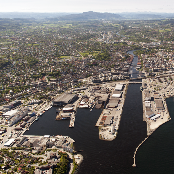
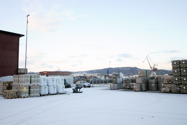
Location Nyhavna, Trondheim, Norway
Population 180,000 inhab.
Strategic site 41.9 ha - Project site 6 ha
Site proposed by Trondheim Havn (in collaboration with Trondheim Municipality)
Owner(s) of the site Trondheim Havn
Commision after competition Planning and building commission
Team representative architect - urban planner - landscape architect
More Information
How can the site contribute to the adaptable city?
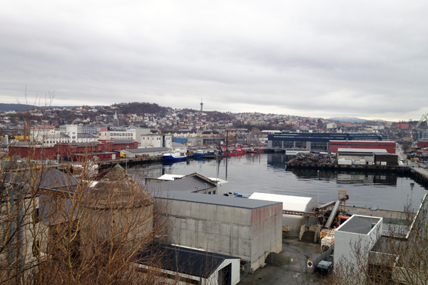
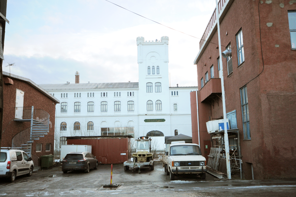
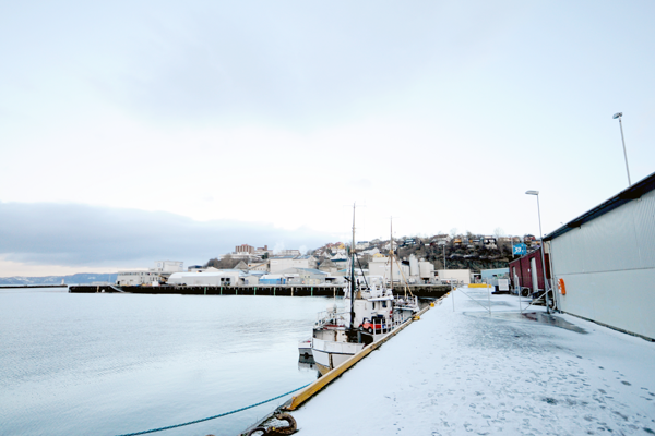
The city of Trondheim wants ideas for Strandveikaia, a site part of the greater Nyhavna harbour area. Distinctive waterfront architecture including WWII structures characterize the area and also provide a tremendous resource for a wide range of actors in culture, innovation and nightlife. A brewery on site, Ringnes, plans for a national centre for beer that can be the starting point for a new ecosystem of new urban life. How can the city create an urban space that acts as an engine for the transformation of the rest of the Nyhavna, adapting to sustainability and a growing Trondheim population?
City strategy
The Europan site is strategically important for Trondheim. Nyhavna sits next to “Midtbyen” the city’s urban core area. There is an ongoing planning process aimed at defining the municipality’s strategy for urban development of these harbour areas. This planning process has taken some time. The main concerns have been the long term planning of future harbor activities in the area in combination with the long term development of Trondheim city. The municipality and the harbor company have collaborated well during the planning process. General guidelines has now been established, and the master plan points at Strandveikaia as a local centre for the residential zone of the greater Nyhavna area.
Site definition
The Strandveikaia site is strategic since it contains buildings that the harbor company itself owns. These are also buildings with short term contracts, meaning they can be easily be part of a first phase in the development of Nyhavna. The brewery is currently reorganizing, moving out its soft drink production and focusing entirely on beer brewing. The brewery wants to build on this by creating a national centre for beer culture with a restaurant and spaces for micro brewing. The majority of the buildings on site are part of a protected cultural historical building district. Built during the war by the Germans (together with the bunkers and other defence systems), the Strandveikaia buildings contained changing rooms and warehouses. Current use is a mix of artist studios, cultural institutions and storage. There is a wish to keep the buildings and build new ones, creating a unique zone facilitating a wide range of activities.
Future of the site in relation to the site family and to Adaptability
A large potential can be realized by developing Strandveikaia. The existing buildings represent an important resource and new buildings can contribute to the creation of a unique area in the city, mixing old and new architecture with an array of programs. An important task will be to examine how the waterfront can be developed over time, considering different scales of interventions and temporary programs. The area is as a game board where several initiatives can be taken simultaneously. The competition should envision how current and new actors can become a part of the future of this area.
Questions on the site
The Brief states that buildings along Strandveien should not be taller than DORA I. Therefore, how tall is the DORA I building? Do we have to use this height as max. reference? If not, can we think of taller buildings as in the rest of the Nyhavna area (5-7 floors)?
The building named Dora I is around 22 meters tall (+ 24.5 meter above sea level). You should use this height as a maximum reference together with the guideline from the municipal master plan that says that the buildings at Strandveikaia should not exceed 5-7 floors.
The level of protection of the heritage to be kept hasn't been defined yet. Do all of the 5 buildings have the same level of building protection - regulation? What kind of interventions can be done (removing floors, making new windows, outer façades, etc.)?
The area of Strandveikaia is due for protection without many details. It is currently a political acceptance to consider the cultural heritage when developing the area. The Cultural Heritage Management Office shows openness towards how the buildings are to be preserved at Strandveikaia and states that the buildings are interesting structures for alterations, transformations and additions.
Related to the buildings on Strandveien. Will photos of the interior be made available in the future?
Interior and exterior images from the site visit is available in the folder 0-New_docs_after_launch with the following labels:
- Images from Strandveien 100: TRONDHEIM-NO-PS-P46 – P64
- Images from Strandveien 98b: TRONDHEIM-NO-PS-P65
- Images from Strandveien 98a: TRONDHEIM-NO-PS-P66 – P75
- Images from Strandveien 96a: TRONDHEIM-NO-PS-P76 – P92
The water area within the Project site will be free of the Port activity and is intended to be used for public uses. Does that mean that it will be clean and unpolluted, and consequently, available for sport activities or other uses that makes use of it?
Yes.
The Masterplan defines Strandveien as the main road, with 4 traffic lines in the near future. However it is also mentioned in the Brief that traffic can be re-routed South to the new National Beer Centre. Is this re-routing a possible situation or it is better to think of the road of a barrier and think of other ways to connect both areas?
We recommend you to show how both scenarios can be implemented in your proposal since this issue is undecided.
In the brief it's not clearly said how many dwellings we should located in the area. Is there a minimum/maximum of housing sqm that should be achieved?
The municipal master plan does not state an accurate number of dwellings planned for the Europan project site. It is up to each team it decide how many.
Is it possible to have any drawings of the other WW2 buildings within the red Study area at pag 17 of the brief?
Drawings of the requested buildings are available in the folder 0-New_docs_after_launch.
- Drawing of Dora I: TRONDHEIM-NO-SS-M2-1.jpg.
- Drawings of Fyringsbunkeren (Skippergata 10): TRONDHIEM-NO-SS-M3-1 - M3-5.pdf.
- Plan of Dora II (Skippergata 16): TRONDHIEM-NO-SS-M4-1.pdf
Should concrete architectural suggestions for the project site be submitted? Are concrete housing proposals expected?
The level of detail should underpin the concept of each project. The same goes for including housing. The Nyhavna area is planned as a new district of Trondheim with the Europan project site serving as a new local centre in this scenario.
Can we design areas with sea water linked with sea shore within the site project?
Yes, participants are free to suggest design solutions for the quay.
Can we modify the position of the vehicle road OHG1 moving it to the right west side of OF11 central recreational park, joining Maskinstgata to Strandveien south in front of Svartlamon, to avoid vehicle traffic between Dora 1 and OF11 park and also in front of building Strandveien 96a?
OHG1 should go along Dora I as suggested on the map on page 11 in the competition brief. However, participants are asked to show the two scenarios for the road; its current location along Strandveien and rerouted south of the National Beer Centre.
Is it possible to sail with recreational boats south of OBR3 bridge?
The depth of the basin is sufficient for both sailboats and motorized boats. The design of the bridge will determine whether or not it's possible to access the basin south of OBR3 by boat.
Is it possible to have piers for recreational boats south of OBR3 bridge?
There is not a great need for this function in the city of Trondheim at the moment, but there are no restrictions on proposing a marina or piers for recreational boats in the municipal master plan. The harbour authority and Trondheim municipality are looking for a creative use of the basin and welcome new ideas.
Can we design a car park building?
This is not asked for in the competition brief nor in the municipal plan.
Can we design parking areas along strandveien?
There are no restrictions on this in the municipal master plan, but the Harbour Authority and the municipality of Trondheim aim at breaking down the barrier of Strandveien to improve the connection between the Europan site and the future National Beer centre.
Is there a maximum or a minimum of volume to be built in addition to the existing heritage buildings to be kept and the kindergarten ?
The density of the site is subject to investigation by the participants. The municipal master plan does not state an exact number on this matter. It is important to note that the Europan project site will not be a profit-maximizing area.
Is it possible to provide the participants with the height lines ( information about the relief) of the site or do we consider the site as flat?
The elevation lines of the site are located in a layer called H_YDEKURVE in the .dxf-file named TRONDHEIM-NO-SS-M1-2.
Is document TRONDHIEM-NO-SS-M1-1 the only existing official material of the master plan? The brown area on it is vaguely defined. Maps on pages 10 and 11 of the brief (TRONDHEIM-NO-C-Pr) show a further detail. Could you provide the original sources of this data? Is there a more detailed programmatic zoning than the one in the first map on page 10?
The document TRONDHIEM-NO-SS-M1-1 is the official illustration of the master plan for Nyhavna. The original files of the diagrams on page 10-11 in the competition brief are available in the folder 0-New_docs_after_launch named TRONDHIEM-NO-SS-M1-4.pdf. The master plan indicates a mix of culture, commerce and housing, but competitors are at liberty to discuss programming freely.
Kindergarten: It is written on page 27 “Outdoor areas (about 25m2 per child, but this can be reduced) should be shared with other relevant users.” Is 25m2 the correct amount? What is it meant by “shared with other relevant users”?
25m2 outdoor area per child is the correct amount according to the regulations, but the participants of Europan are asked to look at the possibility to reduce this by exploring shared functions or alike. Who these other relevant users may be depends on the concept of the project.
Intervention in study area: To what extent is it possible to design and provide a vision for the study area (in between red and yellow boundaries in TRONDHEIM-NO-C-Pr-Correction01)? Is there any clear limit to it? To what extent can we implement/vary the master plan?
The Development in Strandveikaia will define the standard for the larger Nyhavna area, and in that sense affect the strategy for further development of the study area. However, the participants work should primarily be made on the project site level. Participants are not asked to make a new master plan for the study area but to look at overall connections in the area and how the projects site is connected to its surroundings.
Strandveien: According to brief and FAQ, Strandveien can either be maintained where it is expanding it into a 4 lanes road or rerouted south of the brewery. What is meant by south? South of the future National Beer Centre building or south of the Rignes plot (page 3 SITE_VISIT_PRESENTATION_Ringnes)? Could you provide a feasible alternative route?
Please see map named TRONDHIEM-NO-SS-M1-5.pdf in 0-New_docs_after_launch for the two possible routes that are to be considered.
Parks: On page 17 of the brief (TRONDHEIM-NO-C-Pr) it is stated that “the size of the bigger parks should be as indicated in the municipal plan“. Does it imply that, while their dimension must be maintained, their position in the project site and form can be reassessed?
The size (m2) of the parks should be as indicated in the master plan, but their dimensions / shape can be reassessed. The parks should be more or less located where they are indicated in the master plan but adjustments can be made in relation to this if argued for in the project proposal.
Is it available any quantitative data regarding occupants/users and surface usage of the existing buildings in the project site? At least concerning buildings 5, 6, 7 on map on page 16 of the brief. In brief: how much of the existing buildings is actually used?
This information is unfortunately not available.
Train tracks: Is there any information or indication in the master plan or from other sources regarding the currently dead-end train track next to Dora I? And what about the short currently unconnected track along Strandveien inside the project site? Is the only planned station of the area the one of Nedre Elvehavn already existing?
The train track next to Dora I are currently in use. The activity will be phased out when the freight terminal is removed from Brattøra in the future. The short, currently unconnected, track along Strandveien inside the project site is not in use and can be removed.
Can we change the location of park OF8?
The parks should be more or less located where they are indicated in the master plan but adjustments can be made in relation to this if argued for in the project proposal.
Is it compulsory to show the situation with and without the road in case we choose to integrate the existing road in our plan?
It is not compulsory to show both situations, but as this matter is not yet decided upon, it is recommended that the project proposals are robust enough to handle both possibilities.
It seems extremely relevant to provide drawings of the brewery (National Beer Centre).
The plans for the National Beer Centre are not made public, but the main entrance seems very likely to be the existing gate facing east.
Kindergarten: What are the rules that we should follow to design it? Shall we comply to any official regulation? To what extent?
Competitors should base the design on the guidelines given in the brief. Competitors are not expected to go into detail on the design of this function.
This site is connected to the following theme
How to use new inputs to change urban space? How to profit from new inputs to transform urban space and disperse the incoming positive dynamics to adjacent areas to create new urbanities? How to manage potential tensions between the local and translocal activities? These inputs are related either to new public transport network connections or to new programmatic developments. The scale of these incoming urban dynamics varies from the urban agglomeration to the whole world.
Questions on the site
You have to be connected –and therefore registered– to be able to ask a question.
Fr. 16 May 2025
Deadline for submitting questions
Fr. 30 May 2025
Deadline for answers
Before submitting a question, make sure it does not already appear in the FAQ.
Please ask questions on sites in the Sites section.
Please ask questions on rules in the Rules section.
If your question does not receive any answer in 10 days, check the FAQ to make sure the answer does not appear under another label or email the secretariat concerned by the question (national secretariat for the sites, European secretariat for the rules).