Celje (SI)
The Synthetic Site Folder and Site Brief are available for free.
Please register and login to access the Complete Site Folder.
- Synthetic site folder EN
- Site Brief EN
- Site on Google Maps
- Back to map
Data
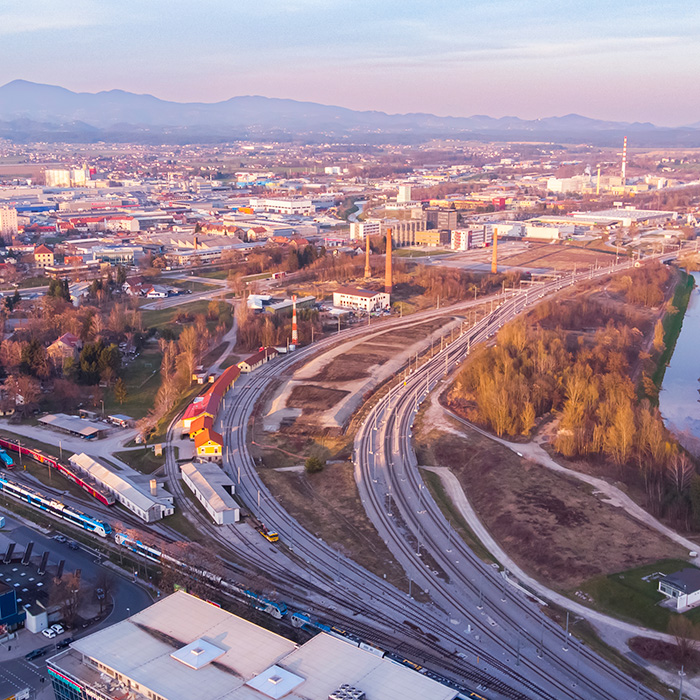
CELJE (SI)
Scales XL/L
Team representative Architect/landscape designer
Location Celje, City Municipality of Celje, Slovenian Styria region
Population 49.007 inhabitants
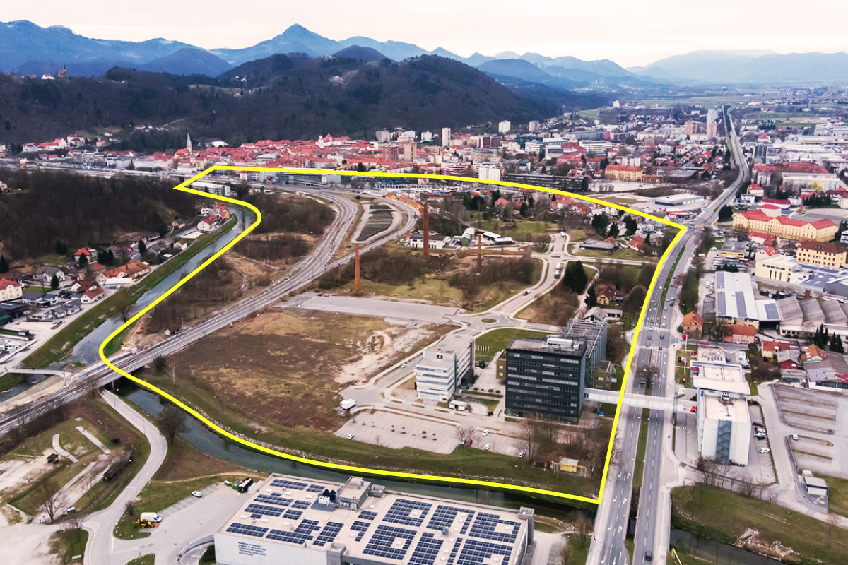
Reflection site 350 ha - Project site 31 ha
Site proposed by City Municipality of Celje
Actors involved City Municipality of Celje
Owner(s) of the site City Municipality of Celje
Commission after competition Preparing the further development of the idea and research as well as preparing the technical studies as a basis for the urban development plan.
More Information
Inhabited milieu's challenges
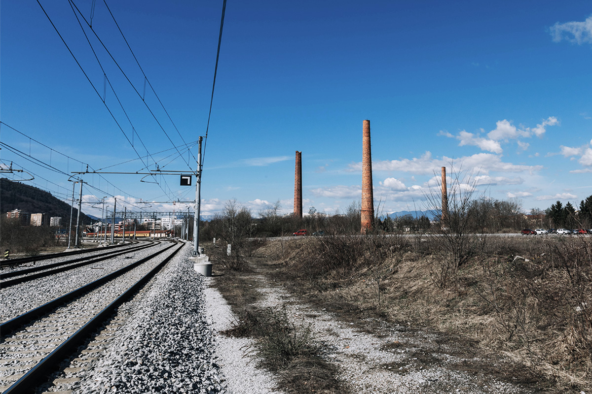
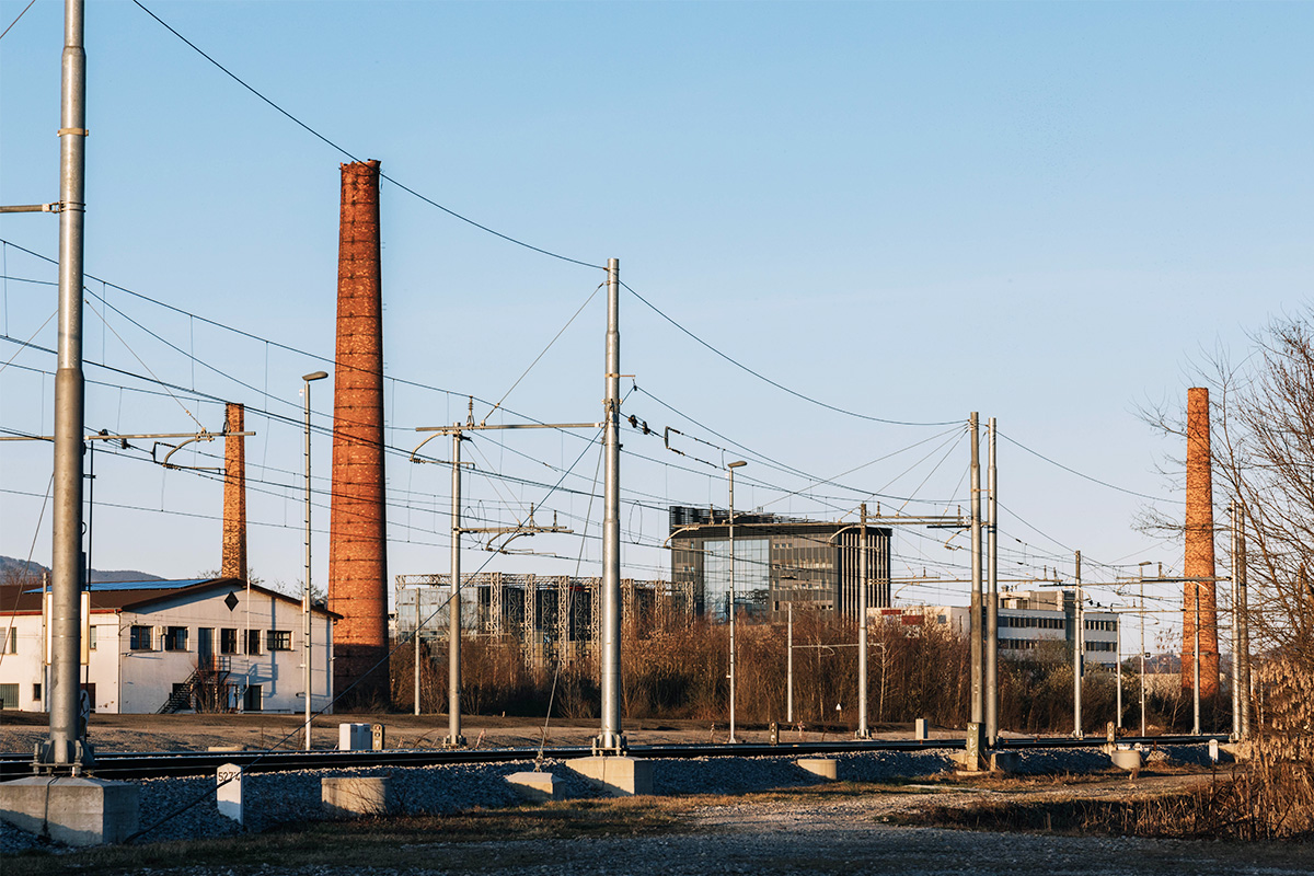
The ‘’Stara Cinkarna’’ (Zinc Smelting Plant) site in Celje is marked by a history of industrial production that has influenced the social, cultural, natural and health conditions of the city and its surroundings. The metallurgical and chemical industry activities that took place on the site for 120 years still have a major impact on the condition and use of the area today, as the soil is heavily contaminated with heavy metals and, in places, mineral oils. Over the last thirty years, the city has been trying to find a solution to prevent the spread of pollution, to reduce its extent or impact, and to manage the pollution. The pollution, the past activities and the associated negative impacts have excluded the site from the mental and actual space of the city, even though it is located in the very centre with excellent connections to the transport network. The site is a place of collective memory and a monument to the development of the city, but the burden of pollution has turned it into an alienated and undesirable place.
Celje wants to reverse the fortunes of a city with some of the worst air quality in the country and a city that is losing citizens to relocation, so targeted development of strategic locations is key. One of these is the ‘’Stara Cinkarna’’ site, which on the surface has exceptional advantages: proximity to the city centre, multi-modal connectivity, regional accessibility, good insolation, large surface area. The challenge of developing the site lies not only in the figurative sense of approaching the burden of history, but also in the literal sense of allowing development on contaminated land that must not be encroached upon or removed. The challenge is to encourage sustainable development of the site that will at the same time prevent further negative impacts of contamination on the immediate and wider surroundings, and to design development that sees the openness and connectedness of the site, rooted in its history, as an essential asset. The burden of space must therefore become its strength.
Questions to competitors
The character of the ‘’Stara Cinkarna’’ site is distinctly twofold: on the one hand it is open, well-connected, and green, while on the other hand it is almost untouchable, closed to development and polluted. The soil is just a thin layer over the industrial waste, the greenery is potentially hazardous, the water is undrinkable. It represents the future and the past of the city, both desirable and undesirable. It all depends on the next steps, which will see the development of the site as part of the development of the city as a whole. Steps that will confront the burden of pollution as the factor that has enabled the city to have the opportunity to set a different development path today, and that are able to tackle and overcome the limits of pollution. Detailed site investigations show the complexity and intensity of the pollution, whose heterogeneity makes it impossible to choose only one approach for the development of the area. Due to the volatility of the pollutants, interventions in the area must be as unobtrusive as possible, otherwise they would spread the pollution further into the wider area. Already widespread pollution means that the benefits of the site - greenery and watercourses - can be detrimental.
The main issues for the development of the site are how to take advantage of the openness, connectivity and centrality of the site as a strategic location for the development of the whole city and to re-evaluate its role in the region, the country and internationally. The answer to this question cannot be offered unless there are clear answers on how to contain, stabilise and nullify the impact of pollution on plants, animals and people in the immediate and wider surroundings. How to cope with more than 10 times the levels of heavy metals in the soil and what attitude should be established towards the vegetation that has grown on these inhospitable soils? All these answers will offer an opportunity to reflect on the creation of a new identity for the site and the city itself, based on the heritage of the past in all its multifacetedness and stimu- lating the orientation of society towards a future of solidarity and sustainability.
Questions on the site
Hello, I have trouble downloading the 2-Reflection Site and 3-Project Site subfloders (the other two, 1& 4, download fine) I have also tried downloading individual items in these floders after rebooting and refreshing the page: everytime i get message "504 Gateway Time-out". Could you please look into it from your side? Thank you
We kindly ask you to try downloading the files again as we are not experiencing any problems at the moment. If you are still unable to download the files, please contact us again!
Hi, I have tried again to download the subfolders: I 've managed to download the 3rd- Project Site, but I am still unable to download the 2nd-Reflection site subfolder (or any individual item in it). I am still getting message "504 Gateway Time-out". Is there any alternative way to receive the material? Thank you
We have checked with the administrator and have tried downloading all the files in the 2nd folder, but no problems have been detected. Please, try again using another browser and/or computer. We will try to find another solution if you are still unable to access the files.
Is there a map (DWG+PDF) available where all the existing trees are mapped and categorized in value, size and kind?
Unfortunately, no such survey has yet been carried out. On site 55 of the brief we have attached the data from diploma thesis, where an inventory of the flora in the area was carried out.
During the site visit the site expert spoke about organic pollution. What exactly is meant with organic pollution? Where on the site is this located?
The topic of organic pollutants is described in detail on page 61 of the competition brief. More data is also available in file SI-Celje-PS-D1, located in folder PS-d_additional documentation. Unfortunately, the document is only available in Slovene. The most illustrative diagrams of groundwater pollution are shown from page 19 onwards.
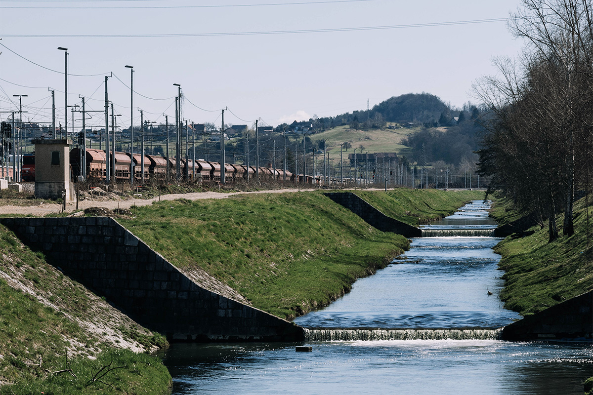
Are all the railroads still in use? And how high is the frequency of railroad traffic?
Railroads are in use throughout the whole day – for passenger and transit traffic.
what is the usage of the existing buildings, especially the buildings along the northern railroad (former station?)?
The buildings along the northern railway line are mainly used for storage and are owned by Slovenian Railways.
Building on plot number 1620/40 is used by Zelenice company, a public company, responsible for the maintenance of the city’s green spaces. Note - on page 46, the location of the Zelenice building is incorrectly labelled.
Is there any information and/or plans from the former masterplan that could be provided?
The former masterplan is not relevant to the development of the site. Regardless, the northern part of the plan is included in the folder 0-New_Docs_after_Launch.
Are the railroads in use 24/7? Or is it (partially) out of use during the night hours?
Only the three southern tracks are in active use. Two additional tracks, located to the north of it, provide a reserve in case of damage to the main tracks. The frequency of traffic is high, as this is the main slovenian railway track line.
There is a pilot project between the railroads about dealing with the soil pollution. Are there any plans /sections and information available?
We are in process of obtaining more information about this pilot project. We will upload additional information as soon as possible.
Why is the soil filling at the pilot project so high?
We are in process of obtaining more information about this pilot project. We will upload additional information as soon as possible.
Is the groundwater level changing during the seasons? How fast and high is it rising during heavy rainfalls? Are there any numbers available? What is the infiltration rate?
Under normal hydrological conditions, the general groundwater flow at the site is weak, in a northward direction towards the Voglajna river in the south. The direction of groundwater flow southwards at normal water level changes at high water level and diverges towards the two streams, the Voglajna and the Hudinja. In the competition area, the estimated groundwater level gradient is 3.5 permille. The advection and transport of pollutants is expected to reach velocities of around 0.2 m/day. The permeability coefficient of the gravel-sand layer is estimated at 10-4 m/s.
There’s more information about the state of both rivers in the document, uploaded to the folder 0-New_Docs_after_Launch.
Are there any floodplans available? Is the level of the river changing during the seasons and heavy rainfalls? Are there any numbers available? What is the current / average depth of the river?
Data about floodplans is available here: http://gis.arso.gov.si/atlasokolja/profile.aspx?id=Atlas_Okolja_AXL@Arso There’s more official data about the environment on this site. Available also in English.
Please refer also to documentation in the folder 0-New_Docs_after_Launch for additional maps of flooding (subfolder SI-CELJE-Waters-data). The source of images is given in the metadata of the files (see - properties/details//comments).
Depth of Voglajna river at the site varies from around 1,2 m to 2,5 m. Depth of Hudinja river in average (not at the site; a bit further upstream) depth is from 0,5 m to 1,7 m.
There’s more information about the state of both rivers available here:
https://www.arso.gov.si/vode/podatki/Povratne%20dobe%20Qvk%2cQnp.pdf
https://www.arso.gov.si/vode/podatki/arhiv/REKE_izpis%20podatkov%20za%202022%201M.xlsx
During the site visit they spoke about biodiversity. Are there any biotopes categorized, are there any protected species?
We believe there isn’t any categorization of bitopes or protected species at the site. For more in depth information about vegetation at the site please visit url: https://repozitorij.uni-lj.si/Dokument.php?id=128404&lang=slv The document is in Slovene, but can be machine (DeepL, Google Translate etc.) translated.
During the site visit they spoke about a tunnel which would build under the site. Are there plans and information available about this project? Does it effect the site at all?
No specific information of the project is currently available, therefore the project does not need to be taken into account.
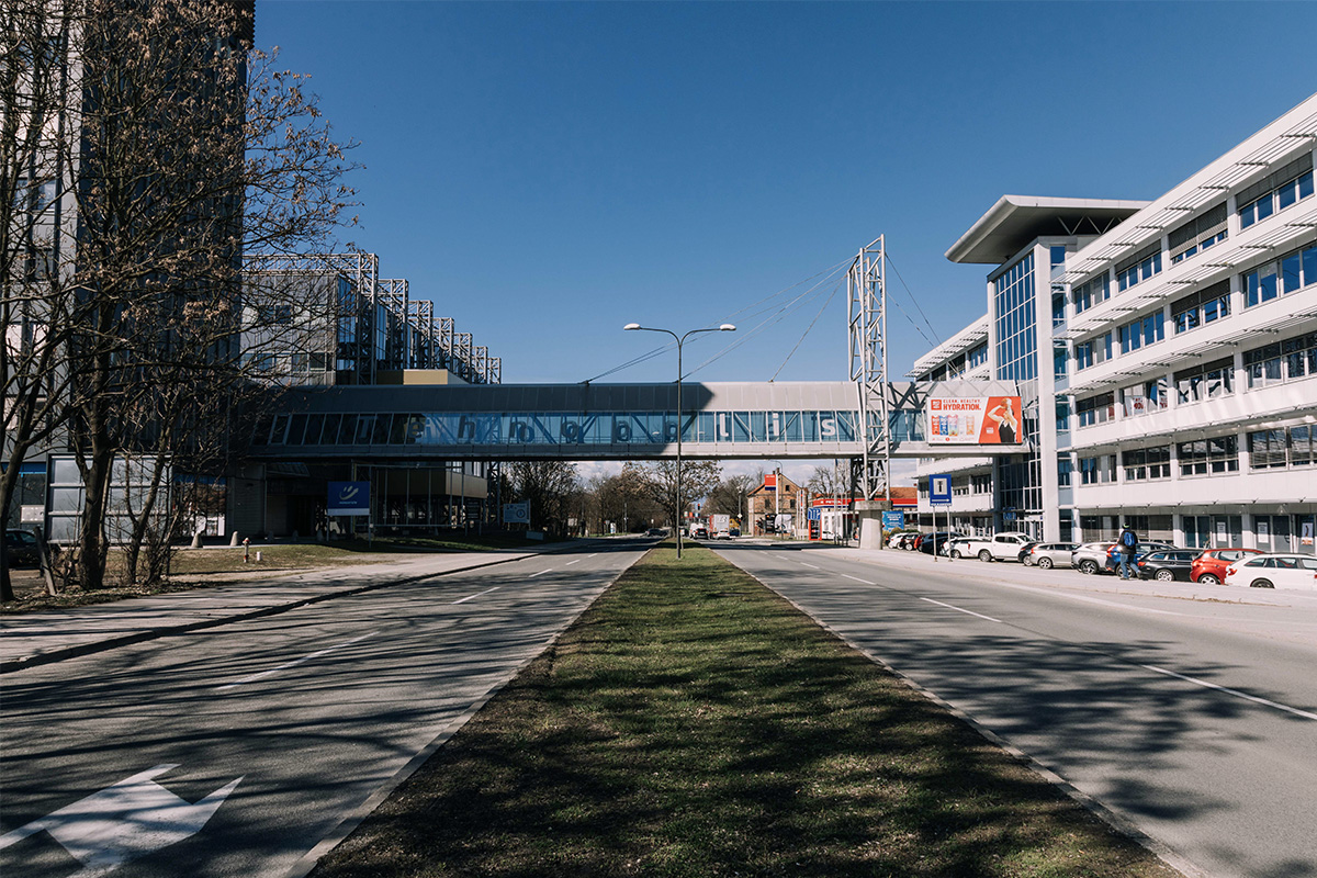
Is Tehnopolis connected by public bus to the city centre today?
No, Tehnopolis is not on the CELEBUS public bus route. Nearest stop is in front of the main bus station and is named Celeiapark.
Is the building of Historical Archives Celje also included in the project site?
Yes, the building is included in the project site, but it must not be demolished.
To the folder 0-New_Docs_After_Launch we have added plan of the site, previously named SI-Celje-PS-M1, but with an addition of outline of the project site (see yellow line).
Are there any plans for a new cycle route on the area?
Yes, we have added detailed plans of the whole route to folder 0-New_Docs_after_Launch.
Is there a climate function/analysis map of Celje (not the whole country of Slovenia) available?
Unfortunately, no such map is available specifically for Celje.
Is there any project or forecast to transform the current train tracks or the train station itself? Is there interest in investing in order to improve communication between the two areas wether it is by burying the tracks, increasing or improving underground passages or including an elevated walkaway?
The existing underpasses are between the Celeiapark building and the Historical Archives, the second one is 200m to the north, runs under both sections of the railway line and is accessible by vehicles. The technical studies envisaged an underpass at the bus station, but this has not been realised. The area needs to be considered holistically and over a longer time horizon (more than 20 years). As it is located in the immediate vicinity of the city and has a major impact on the development of the city centre and Celje as a whole, it is crucial to ensure better connectivity between the areas. It should be noted that the railway infrastructure, including the station, will remain as it is. However, there is a project to transform the current tracks. We are still gathering details of the project and hope we will get them by 16.6.
Although it could be a very approximate range, does the Municipality of Celje estimate an investment figure in the Project Site for the next ten or twenty years?
The estimate will be made on a per ha basis and will follow the framework of engineering and investment costs in similar environmental remediation cases in the European Union. Investiment planing will be done on the basis of the results of the competition and on the following development of the project. Although the budget is not yet determined for the project, there is enough interest for the area that we expect there will be also financial possiblities to develop the area further.
EDIT: Are the railroads in use 24/7? Or is it (partially) out of use during the night hours? Are all the railroads still in use? And how high is the frequency of railroad traffic?
Only the three southern tracks are in active use. Two additional tracks, located to the north of it, provide a reserve in case of damage to the main tracks.
We have added specific traffic frequency data to folder 0-New_Docs_After_Launch.
Is there any limitation to building heights? If yes, does it differ across the site?
No, at the moment there are no such limitation. It is expected that the proposals include building heights that are argumented either by build context or any other reason.
Is it possible to include residential use or secondary residential use (such as student accomodation, hotel, eldery homes etc.) as part of the program for the site?
Permanent residential use has to be avoided, although temporary use is possible (e.g. hotel).
What are the necessary requirements for parking spaces for the possible programs (congress centre, exhibition space, sports hall, etc,) ?
Since the location is close to public transport it’s sensible to limit the amount of parking spaces. The proposals are not obliged to follow the spatial planning act (since it’s changing). As a general rule the requirements are:
-
office buildings 1 PS/70 m2 GFA
-
congress halls, event spaces 1 PS/7 seats
-
retail buildings 1 PS/25 m2
-
museum, libraries 1 PS/80 m2 GFA
-
higher education 1 PS/30 m2 GFA
-
sports halls 1 PS/40 - 25 m2 GFA
-
industry 1 PS/60 m2 GFA
(PS - parking space; GFA - gross floor area).
Progressive approach to soft mobility and parking facilities is welcomed.
EDIT: There is a pilot project between the railroads about dealing with the soil pollution. Are there any plans /sections and information available? Why is the soil filling at the pilot project so high?
The project is ongoing and it is carried out to treat the excavated soil from the reconstruction of the railway line through the brownfield. Due to the contamination, the soil was classified as hazardous waste with the classification number 17-05-03* at the time of excavation. The project to deal with the contaminated soil was given to a company from Šentjur, which uses a patented technology to process the waste into a product called Stonetech. It is a stabilisation technique with simultaneous solidification (S/S method) and is applied on site. This means that the contaminants remain in the material but are not leachable and mobil. The waste is mixed with reagents in a mixing machine and the product must be used within two hours. The material is suitable for road construction, hardened surfaces designed for high compressive loads, etc. In addition to the installation of the material an additional precautionary measure was taken at the site of the track bed, namely the addition of a layer of foil between the installed material and the ground. The platform is intended for use by Slovenian Railways. The section of the mound is in essence homogeneous.
Is it possible to change the level (spot heights) of the railway?
The longitudinal sections are limited by the fact that the station is there. This makes it very difficult to move the railway up and down. Careful attention must also be paid to the bridging structures - the bridge over the Voglajna, the bridge over the Hudinja and the bridge over the Mariborska cesta. It is very difficult to raise or lower the level of the line.
Can the intermodal be placed out of our project site?
Yes, it’s up to the teams to propose best possible sollutions for mobility, use, design and phasing.
What is the maximum height we can build?
There are no restrictions. Sound and argumented sollutions are expected.
Can we remove some lanes of the railway?
Potential line shifts must not worsen the situation for passenger and freight traffic. Expert studies have been carried out in the area, which foresee the abandonment of the track, a new stop and a connecting triangle for the Savinja line.
Here is a textual summary of the document. Graphical material is also available in folder 0_New Docs. Due to the new conditions, the plan is not fully feasible, but can serve as a basis.
The relocation of the freight part of Celje station from the A side of Celje station to the location in Čret has changed the route of freight trains to and from the Savinjska valley. As a result, all freight trains formed at Celje freight station must first import at Celje passenger station, change locomotive side and proceed to Savinja line. The same applies in reverse. This means not only more work in preparing and dispatching trains and more energy consumption, but also more danger at Celje passenger station, as well as an increase in noise in the the city centre itself. Thus, several years ago, an initiative was launched to connect the Savinja line with the station Celje freight with a continuous arc in the area of LN Gaberje South.
In 2004, an off-grade crossing with Mariborska cesta was carried out, bounding one leg of the federal arc.
For the needs of the city of Celje, it is possible to relocate the service activities of the railway from the existing location at the to a new location on the A side of Celje Freight Station (Čret). The space is suitable as it allows for a connection to the existing station tracks.
Relocation of rail service activities to the Celje - freight station site is a prerequisite for the construction of the the southern part of the Gaberje South LN. The construction phases will follow the following order:
- relocation of railway service activities to the site next to Celje - tovorna station (Čret);
- construction of two road underpasses under the future railway tracks of the Celje - Velenje line; and the connecting track;
- construction of two tracks of the 'Southern Railway';
- construction and construction of the planned tracks on the Celje - Velenje line and the connecting track;
- construction of the south-western access to the Gaberje South LN;
- construction of the facilities foreseen by the Gaberje South LN.
This site is connected to the following theme
THINK TABULA NON-RASA! Some nature reserves around the world are deserts –hot or cold–, but they host all kinds of animals and microorganisms hiding in the cracks and crevices, under the rocks. Some of our sites look empty, vacant, but they are not. They are full of life: in the soil, in the air, in the breeze. They are part of a larger balance of natural forces and processes. On these sites, substantial new volumes of programme are required. Think of these sites as the opportunity to multiply the number of life forms, think of the request to build new habitats as an opportunity to design a holistic environment. Think tabula non-rasa!
Designing new habitats as a holistic environment
Specific documents
Questions on the site
You have to be connected –and therefore registered– to be able to ask a question.
Fr. 16 May 2025
Deadline for submitting questions
Fr. 30 May 2025
Deadline for answers
Before submitting a question, make sure it does not already appear in the FAQ.
Please ask questions on sites in the Sites section.
Please ask questions on rules in the Rules section.
If your question does not receive any answer in 10 days, check the FAQ to make sure the answer does not appear under another label or email the secretariat concerned by the question (national secretariat for the sites, European secretariat for the rules).