Madrid (ES)
The Synthetic Site Folder and Site Brief are available for free.
Please register and login to access the Complete Site Folder.
- Synthetic site folder EN | ES
- Site Brief EN | ES
- Site on Google Maps
- Back to map
Data
Madrid (ES)
Scales L/L
Team composition Architect mandatory
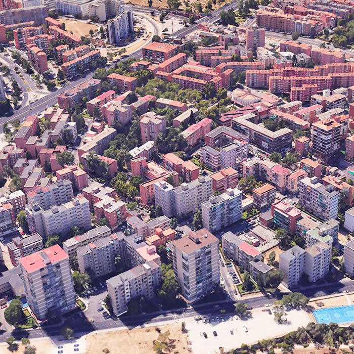
Location Colonia Casa de Campo, Madrid
Population 11,676 inhabitants
Reflection site 35,50 - Project site 35,50 ha
Site proposed by Madrid City Council
Actors involved Directorate for Urban Regeneration and Latina District
Owner(s) of the site Madrid City Council
Commission after competition
- Preliminary project for the urbanisation of the collective open spaces owned by the municipality, with the possibility of extending it to other open spaces.
- Development and implementation of the proposed participatory process to involve the population.
More Information
SITE / CONTEXT
Madrid, with more than three million inhabitants, has an economically and socially very diverse population. It is a complex city, in constant transformation, made up of very different urban fabrics, characteristic of the different periods in which they were built.
Madrid City Council is promoting a Strategic Neighbourhood Regeneration Plan for pre-1985 residential urban fabrics .
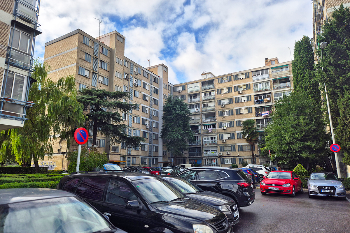
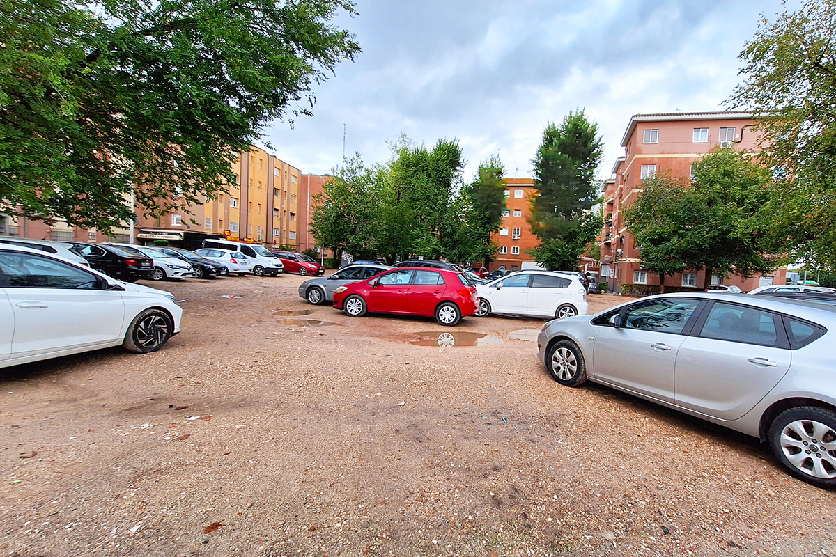
This Plan defines more than 400 neighbourhood units (UB) as territorial areas suitable for the diagnosis and urban regeneration project. The Action Plan is the instrument to implement the regeneration strategy in each neighbourhood unit, in order to transform them into healthy neighbourhoods. Almost half of these units are neighbourhoods built between the 1950s and 1980s to shelter the immigrant population. These peripheral residential estates are made up of large ‘superblocks’ in which different types of free-standing residential blocks have been arranged, forming an ensemble alien to the traditional notions of streets, plots, etc.
The open spaces, which barely make up a minimal road network, are characterised by the presence of mostly inter-block spaces for collective use, halfway between the public and the domestic. Poorly urbanised and lacking in accessibility, these collective spaces present biophysical conditions of opportunity compared to other more compact neighbourhood units.
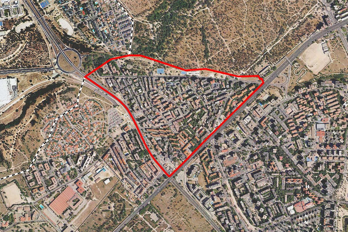
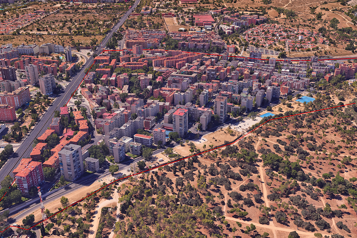
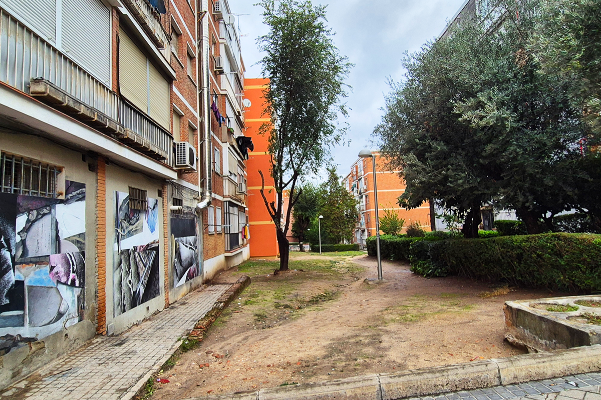
The Colonia Casa de Campo is one of these neighbourhood units of the open block city. It is both the reflection and project site.
Located to the west of the municipality, it is bordered to the north by areas of high environmental quality, either consolidated (Casa de Campo) or potential (Meaques stream). Its south-eastern and south-western limits are formed by important road infrastructures that separate it from other similar units.
In its road network, several renovation works are being carried out.
It has been declared a preferential area for urban regeneration due to its socio-economic conditions of vulnerability.
In order to characterise the colony, the average parameters of this type of neighbourhood units have been used, including socio-spatial indicators. The socio-economic index integrates data on household income and the real estate value of the buildings.
QUESTIONS TO COMPETITORS
The competition proposes a reflection on the urban regeneration of Colonia Casa de Campo.
The aim is to produce an Action Plan, a comprehensive proposal for urban regeneration that will include: a qualitative diagnosis, the design of a participatory process and a proposal for intervention in the open spaces. Its replicability to other similar neighbourhoods will be assessed.
How should this Action Plan be conceived to be a tool for urban regeneration?
How should this regeneration be oriented to transform the neighbourhood into a healthy one?
The projects on open spaces must improve their conditions of accessibility, safety, sustainability and coexistence. It is a challenge to rethink open spaces as catalysts for transformation towards a healthy neighbourhood. This proposal begins in the municipal collective spaces, which are immediately available, halfway between public and domestic, but can be extended to other open spaces and even built-up spaces.
What is the role of these collective spaces in the urban regeneration of the neighbourhood? How can these spaces improve sustainability and health?
How could they be managed by involving citizens?
Questions on the site
Is it possible to have a 3d (ifc or other format) of the intervention area?
It is possible to use the three-dimensional viewer of the geoportal in the following link: https://geoportal.madrid.es/IDEAM_WBGEOPORTAL/visor_3d.iam
And even download the model in this link: Modelo tridimensional de edificaciones de la cartografía base municipal. - Geoportal del Ayuntamiento de Madrid
Quite a bunch of the folders in the site folders are empty. Is this data gonna be uploaded at a later moment?
Could you please specify which folders you are referring to? We see them correctly
Is there an information about which collective spaces are in neighbourhood ownership? And what sort of ownership does that imply? Some sort of community of owners who convene regularly about issues of the shared property? ¿Existe información sobre qué espacios colectivos son propiedad del vecindario? ¿Y qué tipo de propiedad implica? ¿Algún tipo de comunidad de propietarios que se reúne periódicamente para tratar asuntos de la propiedad compartida?
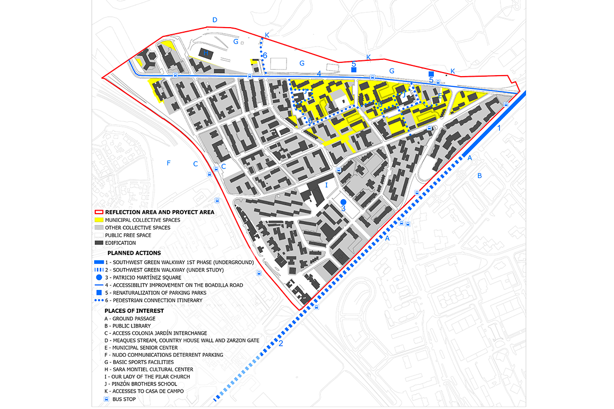
The initial project area is the municipally-owned public areas shown on the map (yellow).The project may be extended, exceptionally and justifiably, to other privately owned collective spaces identified on the map (grey), but considering that the execution of works in these spaces could be delayed. This map (see “New documents after launch”), drawn up by the Universidad Politécnica de Madrid, identifies three forms of ownership of these collective spaces:
- Per plot: a single Community is the owner of the collective spaces (dark grey on the plan).
- Jointly owned: several Communities are the owners of the collective spaces (plain green on the plan).
- Remaining original owner: the original developer remains the owner of the collective spaces (hatched green on the plan).
Governance of collective spaces:
- Private easements: collective spaces must provide access and views to the dwellings they serve.
- Public easements: many collective spaces have public rights of way.
- Use: the conditions of use of collective spaces are decided by the owner, by majority vote.
- Conservation: the City Council assumes the conservation of private collective spaces for public use (blue on this map). But not their refurbishment.
- Works: works are decided by the owner, by unanimity.
- Decisions: the communities of owners meet regularly.
- Other initiatives: Both the neighbourhood residents' association and the homeowners' associations submit requests and receive requests related to the collective spaces.
In the framework of the Regenera Madrid Plan, the necessary tools are being developed to regulate privately owned collective spaces, which will allow for future municipal works.
El ámbito inicial del proyecto son los espacios colectivos de propiedad municipal que se localizan en el mapa de la ficha (amarillo). El proyecto podrá extenderse, excepcional y justificadamente a otros espacios colectivos de titularidad privada que se identifican en ese mapa (gris), pero considerendo que la ejecución de obras en los mismos podría demorarse. Este plano, elaborado por por la Universidad Politécnica de Madrid, localiza tres formas de la propiedad de estos espacios colectivos:
- Por parcela: una única Comunidad es la propietaria de los espacios colectivos (gris oscuro en el plano).
- Resto mancomunado: varias Comunidades son las propietaria de los espacios colectivos (verde liso en el plano).
- Resto de propietario original: la promotora original continúa siendo la propietaria de los espacios colectivos (verde tramado en el plano).
Gobernanza de los espacios colectivos:
- Servidumbres privadas: los espacios colectivos deben proporcionar acceso y vistas a las viviendas a las que sirven.
- Servidumbres públicas: muchos espacios colectivos tienen servidumbre de paso público.
- Uso: las condiciones de uso de los espacios colectivos las decide el propietario, por mayoría.
- Conservación: el Ayuntamiento asume la conservación de los espacios colectivos privados de uso público (azul en este mapa). Pero no su reforma.
- Obras: las obras las decide el propietario, por unanimidad.
- Decisiones: las comunidades de propietarios se reúnen con regularidad.
- Otras iniciativas: Tanto la asociación de vecinos del barrio como las comunidades de propietarios presentan solicitudes y reciben requerimientos relacionados con los espacios colectivos.
En el marco del Plan Regenera Madrid, se están elaborando los instrumentos necesarios para regulazar los espacios colectivos de propiedad privada que permitirá en el futuro la ejcución de obras municipales.
Is there some information about the ownership of the houses? ¿Existe alguna información sobre la propiedad de las viviendas?
All the dwellings in the Casa de Campo housing state are private. The dwellings in each building are grouped into a Community of Owners, which is the owner of the common elements.The tenure status, expressed as number of rented households in relation to the total number of dwellings, of the state is 27,92%, compare to the district average of 20,92%, or the 20,80% average of the comparisonsample of similar open block regeneration units.
Todas las viviendas de la colonia Casa de Campo son de titularidad privada. Las viviendas de cada edificio se agrupan en una Comunidad de Propietarios, que es la propietaria de los elementos comunes. El régimen de tenencia, expresado en número de hogares en régimen de alquiler respecto del número de viviendas totales, de la colonia es de un 27,92%, frente al 20,92% de media del Distrito ó al 20,80% de media del conjunto de ámbitos de regeneración de bloque abierto.
Are the square at the exit of the colonia jardín metro station and the adjoining plot to the south municipal property, and can they form part of the proposed intervention? ¿son de propiedad municipal la plaza de salida del metro colonia jardín y la parcela colindante por el Sur? ¿pueden formar parte de la propuesta de intervención?
Yes, both areas are municipal property. The metro exit is the gateway to the neighbourhood for the vast majority of its inhabitants and treating this area as a unit, giving it importance, will be valued in the proposals.
Si, ambos ámbitos son de propiedad municipal. La salida del metro es la puerta del barrio para la gran mayoría de sus habitantes y tratar ese entorno de manera unitaria, dándole importancia, será valorado en las propuestas.
I understand that the yellow areas are the preferred areas for intervention, but during the visit some areas were identified (in grey on the map) that we found very attractive. can action be taken on them? Entiendo que las áreas amarillas son las preferentes en cuanto a actuaciones, pero en la visita se han localizado algunas zonas (en gris en el plano) que nos han parecido muy atractivas. ¿puede actuarse sobre ellas?
Proposals can certainly be made for the whole area. It is a question of finding strategies to improve the whole colony. It must be taken into account that these areas, shown in grey on the map, do not belong to the municipality. Prior to any action in these inter-block spaces, it will be necessary to take into account the interests of the owners and/or neighbours of the dwellings overlooking them, and it will probably be necessary to draw up a planning instrument that will be associated with a process of citizen participation. The proposed actions cannot be implemented in the foreseeable future.
Sin duda pueden hacerse propuestas sobre todo el ámbito. Se trata de encontrar estrategias para mejorar toda la colonia. Ha de tenerse en cuenta en esas zonas, representadas en gris en el plano, no son de propiedad municipal. Será necesario previamente a cualquier actuación en estos espacios interbloques, tener en cuenta los intereses de los propietarios y/o vecinos de las viviendas que dan a ellas, y probablemente será necesaria la redacción de un instrumento de planeamiento que llevará asociado un proceso de participación ciudadana. Las actuaciones propuestas no podrán realizarse en un plazo cercano.
Regarding the axis of the Boadilla road. It is clear from the visit that the opening of the colony to the country house is fundamental, but nevertheless the wall of the country house is not very permeable. is it possible to modify it? Sobre el eje de la carretera de Boadilla. Queda claro en la visita que la apertura de la colonia a la casa de campo es fundamental, pero sin embargo el muro de la casa de campo es muy poco permeable. ¿es posible modificarlo?
The wall of the country house is the boundary of the project area, but it is part of the Historic Site declared an Asset of Cultural Interest (BIC) in 2010, in accordance with the Historic Heritage Law of the Community of Madrid. The interventions proposed on this site and in its declared surroundings, including proposals on its enclosure, must be highly justified and must be approved by the Local Historical Heritage Commission in application of the intervention criteria contained in its declaration as a BIC, mainly related to the recovery of its historical layout and the traditional construction system corresponding to the period of each section.
El muro de la Casa de Campo es el límite del ámbito del proyecto, pero forma parte del Sitio Histórico declarado Bien de Interés Cultural (BIC) en 2010, de acuerdo con la Ley de Patrimonio Histórico de la Comunidad de Madrid. Las actuaciones que se propongan en ese sitio y en su entorno declarado, incluidas propuestas sobre su cerramiento, han de estar muy justificadas y han de ser aprobadas por la Comisión Local de Patrimonio Histórico en aplicación de los criterios de intervención que figuran en su declaración como BIC, relacionados principalmente con la recuperación de su trazado histórico y del sistema constructivo tradicional correspondiente a la época de cada tramo.
We have studied the presence of BiciMad in the area and there is only one station and it is far from the metro. can more be proposed? Hemos estudiado la presencia de BiciMad en el ámbito y hay solo una estación y alejada del metro. ¿pueden proponerse más?
Mobility is one of the issues that should be addressed in the diagnosis and urbanisation guidelines of the Action Plan to bring the neighbourhood closer to the healthy neighbourhood model. Both pedestrianisation proposals and new bicimad locations can be part of these guidelines.
La movilidad es uno de los temas que deben abordar el diagnóstico y las directrices de urbanización del Plan de Acción para acercar la colonia al modelo de barrio saludable. Tanto las propuestas de peatonalización como de nuevas ubicaciones de bicimad pueden formar parte de esas directrices.
Is it possible to propose to transform a road that is currently used by vehicular traffic into a pedestrian one? ¿Se puede proponer transformar una vía que actualmente es de tráfico rodado en una peatonal?
Mobility is one of the issues to be addressed in the diagnosis and urbanisation guidelines of the Action Plan in order to bring the neighbourhood closer to the healthy neighbourhood model. Proposals for pedestrianisation can form part of these guidelines, always within the framework of a comprehensive mobility proposal that considers the hierarchisation and modal specialisation of roads.
La movilidad es uno de los temas que deben abordar el diagnóstico y las directrices de urbanización del Plan de Acción para acercar la colonia al modelo de barrio saludable. Las propuestas de peatonalización pueden formar parte de esas directrices, siempre en el marco de una propuesta integral de movilidad que considere la jerarquización y especialización modal de los viarios.
This site is connected to the following theme
Re-sourcing from social dynamic How to transform urban areas and enclaves into open neighbourhoods? How to constitute the smallest urban entity of proximity, exchange and governance, consisting of humans and more than humans? Open urban neighbourhoods can be enablers of citizenship and accommodators of diverse temporalities of stay. They may be pivotal sites for initiating and implementing social and ecological changes, rippling through the rest of the city, thus being valuable for the European Green Transition.
Promoting open Neighbourhoods
Specific documents
Questions on the site
You have to be connected –and therefore registered– to be able to ask a question.
Fr. 16 May 2025
Deadline for submitting questions
Fr. 30 May 2025
Deadline for answers
Before submitting a question, make sure it does not already appear in the FAQ.
Please ask questions on sites in the Sites section.
Please ask questions on rules in the Rules section.
If your question does not receive any answer in 10 days, check the FAQ to make sure the answer does not appear under another label or email the secretariat concerned by the question (national secretariat for the sites, European secretariat for the rules).