Brignoles (FR)
The Synthetic Site Folder and Site Brief are available for free.
Please register and login to access the Complete Site Folder.
- Synthetic site folder EN | FR
- Site Brief EN | FR
- Site on Google Maps
- Back to map
Data
Brignoles (FR)
Scales XL/L
Team composition Architect mandatory
Location Brignoles, Var, Provence-Alpes-Côte d’Azur (13)
Population 17,846 inhabitants
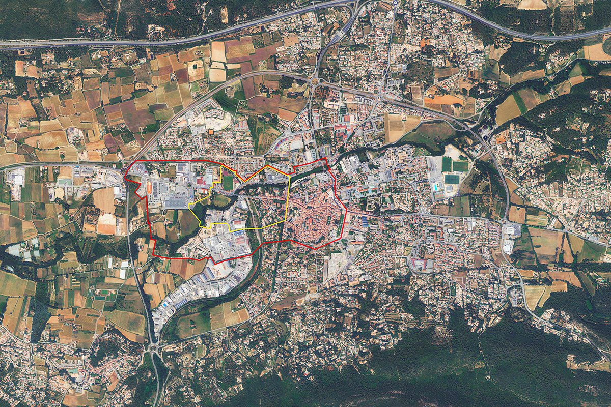
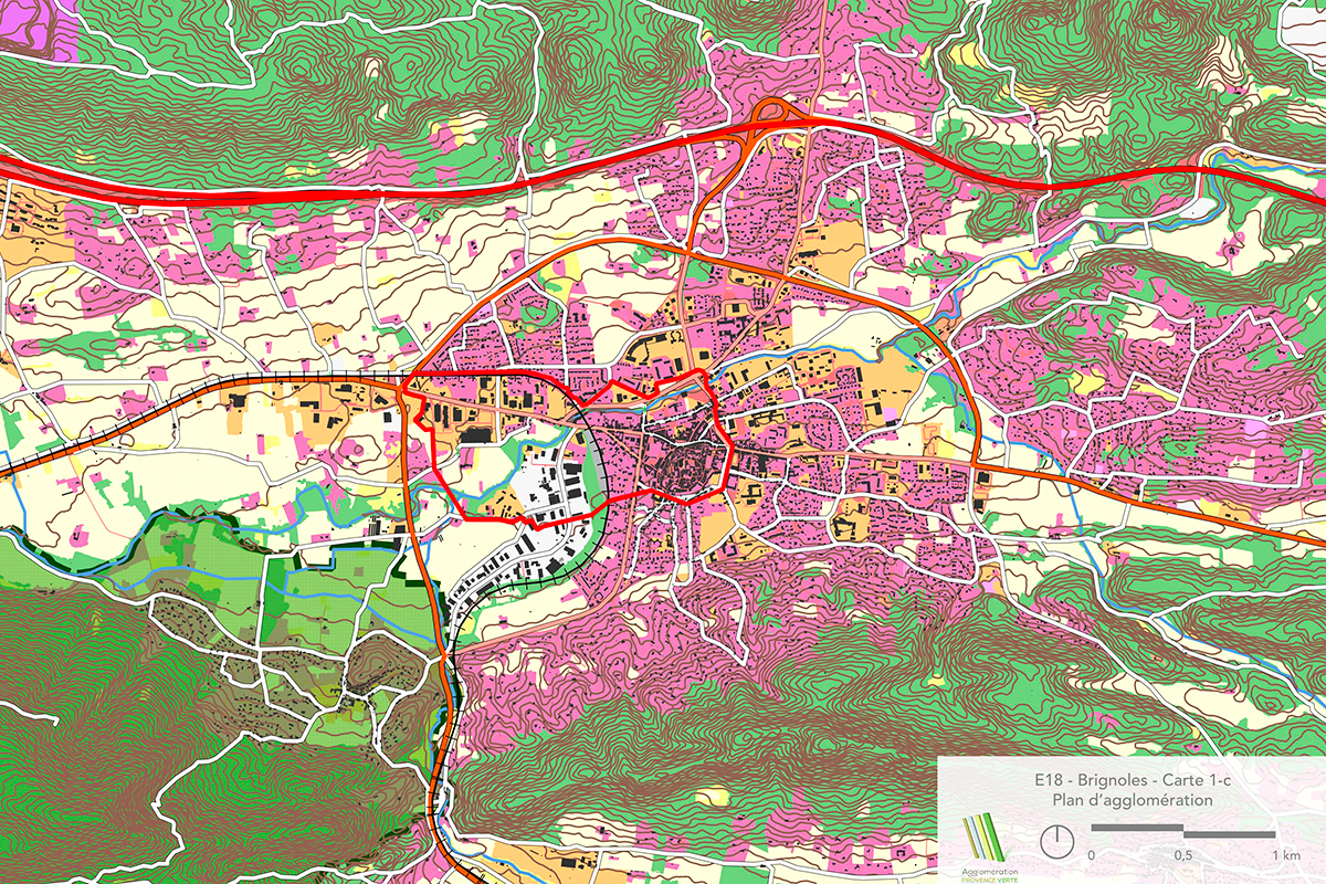
Reflection site 109.7 - Project site 27.9 ha
Site proposed by City of Brignoles and Communauté d’Agglomération Provence Verte
Actors involved City of Brignoles and Communauté d’Agglomération Provence Verte
Owner(s) of the site Public and private properties required expertise based on site challenges
Commission after competition Study and project missions to refine strategic proposals for the redevelopment of Brignoles’ western gateway (such as a master plan), feasibility studies for the project site, and architectural, urban, or landscape design and project management tasks.
More Information
SITE/CONTEXT
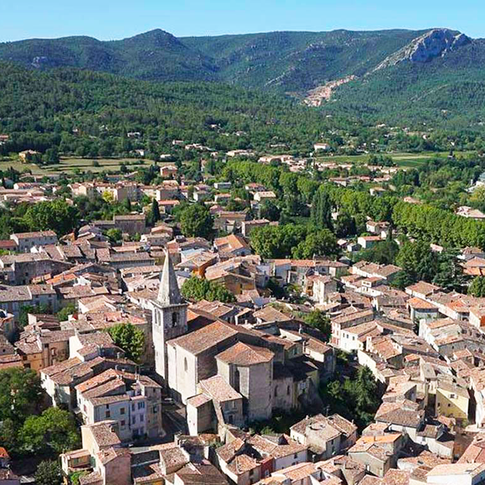
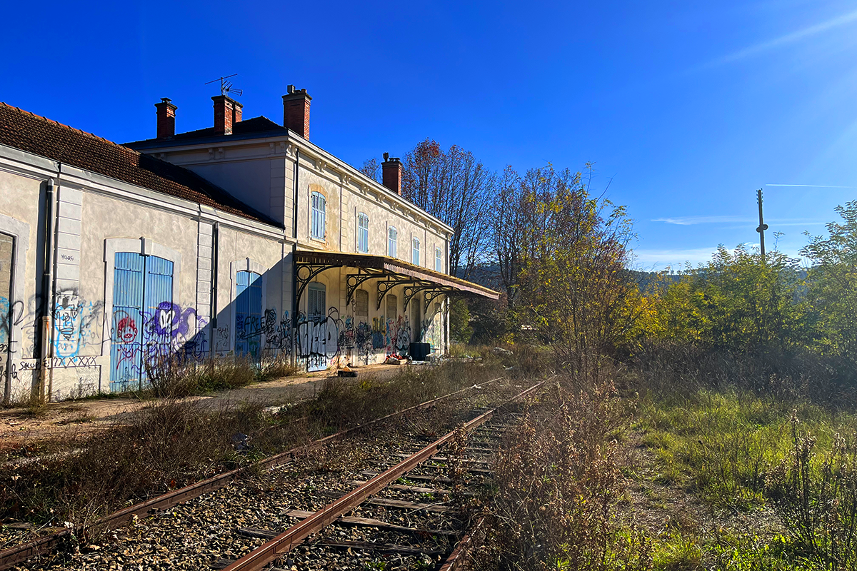
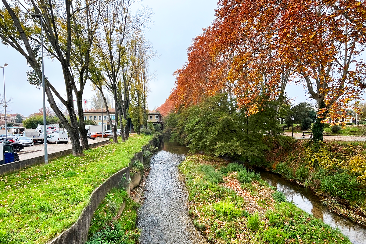
Brignoles stands at the confluence of several structuring forces shaping the cultural landscape of the Var region. The town has developed at the heart of a historic and dynamic agricultural plain, nestled between the Caramy River and the Sainte-Baume massif. Its strategic position—once a key transit point along international routes since antiquity—situates it at the center of a vast watershed, within a territory punctuated by a now-disused railway network. This site presents a unique opportunity to redefine the relationships between the region’s diverse resources.
The second half of the 20th century saw the rise of the automobile, reshaping mobility patterns. Highways, ring roads, and expressways gradually overshadowed the former Nationale 7—once the emblematic holiday route—along with the railway axis linking Brignoles
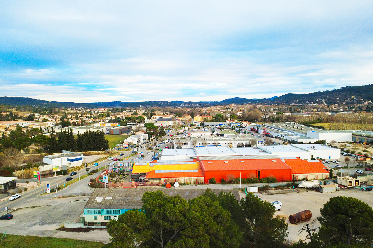
to Paris. The decline of bauxite mining gave way to new industrial zones, established on former market gardening lands surrounding the historic center. Initially dedicated to agricultural cooperatives serving the plain’s producers, these zones later diversified their economic activities. The Consacs area and
the Saint-Jean commercial district exemplify these transformations. Meanwhile, the Gare district, close to the town center, witnessed the decline of its railway infrastructure, evolving into a low-density residential area. Over time, the region’s hydrographic network, increasingly constrained by sprawling urbanization,
has struggled to absorb the Mediterranean climate’s episodic floods.
The project site brings together several distinct urban entities west of the historic center, which has been designated as a Remarkable Heritage Site. These single-purpose urban fabrics follow one another, characterized by architectural and functional discontinuities. The predominance of the automobile has rendered the city less accessible and inclusive, while extensive mineralized surfaces and unremarkable architectural forms have limited the presence of nature within the urban environment.
The municipality and the wider metropolitan area seek to clarify and enhance the western gateway to Brignoles, reestablishing connections between the peripheral neighborhoods along the former Nationale 7 and the town center, a designated priority district. The redevelopment of Brignoles’ architectural heritage, acquired by public authorities, could accommodate new public services, creating urban landmarks and a coherent programmatic dynamic. This transformation would not only enhance the western entrance to the town but also encourage greater engagement with the historic center. Through this approach, Brignoles aspires to reclaim its historical character, highlighting its architectural legacy while reinforcing its identity for both residents and visitors alike.
QUESTIONS TO THE COMPETITORS
What imaginary should the western gateway to Brignoles embody to create a holistic, accessible, and inclusive transition between the historic town and its periphery?** How can infrastructure be reimagined to reinforce its urban character? In what ways can the agricultural landscapes of Provence Verte and Brignoles’ history as a hub of trade and cultural exchange inform this vision?
Articulate, connect, link. What long-term vision can be proposed for the town’s western gateway and its relationship with the former Nationale 7, as well as the surrounding urban, rural, and riverine spaces? How can calmer urban connections and new programs enhance the quality of life, foster inclusion, and strengthen Brignoles’ appeal?
Experiment and transform. How can certain areas be unlocked through the requalification of public space and the introduction of new programs? What thresholds should be created to reinforce connections? How can districts shaped by different historical layers be meaningfully linked? How can urban journeys toward the town center be enriched?
Reuse and enhance. How can landscape resources be integrated into the urban fabric to encourage interaction with residents? What potential for reuse can be envisioned for vacant or obsolete buildings to help structure the town’s entrance? What strategies could be implemented to weave agricultural plots into the surrounding urban fabric?
Questions on the site
Bonjour, Est-il possible d'avoir la liste des parcelles et bâtiments appartenant à la mairie ou à un organisme d'État au sein de la commune ? Merci !
A map showing “public” land holdings has been posted online in the “new docs after launch” folder.
Bonjour, pourriez vous nous communiquer les documents graphiques du projet portant sur les berges du Caramy présenté lors de la visite le 8 avril ? (idéalement dans des formats modifiables) Merci
The Syndicat Mixte de l'Argens provides several GIS layers containing the developments planned for Brignoles as part of action 45 of the PAPI.
https://www.syndicatargens.fr/
Bonjour, Lors de la visite, vous nous avez présenté votre projet d'aménagement et de gestion des berges du Caramy, pourriez vous nous envoyer les ressources liées (plans/ coupes en dwg notamment)?
see question below
Ensuite, Pourriez vous nous partager un plan de domanialité? (propriétaires foncier) Enfin vous aviez évoqué une charte pour l'encadrement de la publicité en secteur commercial, avez vous des éléments communicables sur ce sujet?
A map with the public properties has been added in the folder "new docs after launch"
The city of Brignoles approved its Local Advertising Regulations in 2023. They are available at this address:
Bonjour, Nous avons eu l’info qu’un projet de ferme maraîchère municipale est prévu ? Si oui, où serait-elle implantée et dans quels délais ? Merci par avance
A municipal/community market garden is planned for the plots of land registered as BD 314 to 321 + 758 +760.
No timetable has been set at this stage.
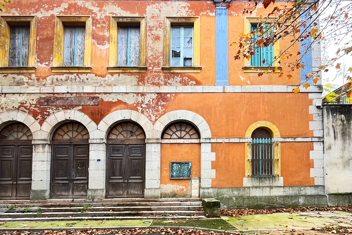
Bonjour, Nous avons entendu qu'il était envisagé d’installer un théâtre à la place de l’ancien palais de justice ? Ce projet est-il toujours d'actualité ? Si oui, quel serait le calendrier de réalisation ? Merci par avance
Today, the city is thinking about turning the courthouse building into a hotel.
Bonjour, Quel avenir est prévu pour l’ancien bâtiment du cinéma « La Boîte à Images » ? Y a-t-il un projet de reconversion ou de réhabilitation en cours ? Merci par avance
no known project by now.
Bonjour Des rumeurs évoquent une possible délocalisation de la foire Brignoles. Est-ce fondé ? Si oui, vers quel site serait-elle déplacée et pour quelles raisons ? Merci par avance
This possibility was considered at one point, but is no longer relevant.
Bonjour, Nous avons qu'il aurait un projet de crématorium est-il bien en cours ? Si oui, où sera-t-il situé et à quel horizon ?
The crematorium project is planned for plot AO 811, and the public contract for the public service delegation (design, construction, and operation) is currently under consultation.
It is scheduled to be operational by 2028.
Bonjour, Nous avons vu qu'un futur pôle multimodal est prévu; Où serait-il situé ? Quelles sont ses fonctions prévues et son calendrier ? Merci par avance
An initial location scenario projected the PEM on plot AW 196. This scenario was abandoned considering its potential impact on heavy traffic on Avenue des Berges. Other land surveys are underway and should enable suitable land to be found between the motorway roundabout and Brignoles town center.
The PEM must be able to accommodate a sales office for mobility operators, serve as a transit point for regional and local buses, have bicycle lockers, and be easily accessible on foot.
Bonjour, avez-vous les plans du palais de justice et du stade municipal Raoul Delpon à nous partager? Merci pour votre retour.
No, we don't have those plans.
Bonjour, Les sites du stade Raoul Delpon et l'ensemble des bâtiments de l'îlot du palais de justice sont identifiés comme des opportunités de projet. Existe-t-il des plans de ces différents bâtiments ? Si oui est-il possible de le communiquer aux candidats ?
All the documents we could gather are on the server.
Bonjour, La mairie a évoqué un projet hôtelier en cours sur l'îlot du palais de Justice. Peut-on avoir plus de précisions quant à son emprise au sein du bâti existant, sa programmation et sa temporalité ?
There is no additional information on this subject. This programmatic orientation is still in its infancy.
Bonjour, Existe-t-il des plans dwg du projet d'élargissement des berges du Caramy ? Si oui est-il possible de le communiquer aux candidats ?
The Syndicat Mixte de l'Argens provides several GIS layers containing the developments planned for Brignoles as part of action 45 of the PAPI.
Bonjour, Existe-t-il des plans de l'ancienne gare SNCF ? Si oui, est-il possible de les communiquer aux candidats ?
We couldn't collect plans from the train station.
Bonjour, Lors de la visite de site, la ville nous a dit que les rails devaient rester en place pour un usage éventuel en cas de guerre. Est-il possible d'avoir des précisions sur la législation à ce sujet ? Notamment sur l'emprise concernée par cette mesure et si des aménagements semi-permanents peuvent être autorisés.
The tracks belong to RFF. If the tracks are removed, then the city will be obliged, at its own expense, to restore them if the line is ever to be used again.
The city does not wish to bear this cost.
However, it is entirely possible to imagine devices that protect the existing rails / do not damage them.
Negotiations with RFF and SNCF do not seem to have been successful. This may be a challenge to be taken up after the competition by the winning teams who have begun to consider the development of the rail network.
This site is connected to the following theme
Re-sourcing from social dynamic A missing layer of urbanity is added on a territory with underlying complexities. In all these large sites, the question is how inhabit them, how to relate to them, how to add a human ecosystem while negotiating the pros and cons of the existing complexity. It may be to reconsider an urban interrupted development, to care wounds left or created by old or new infrastructures; to regenerate sub-standard housing or the damage left behind a brownfield, to reconsider a river or former agricultural fields.
Creating New Urban Relationships
Questions on the site
You have to be connected –and therefore registered– to be able to ask a question.
Fr. 16 May 2025
Deadline for submitting questions
Fr. 30 May 2025
Deadline for answers
Before submitting a question, make sure it does not already appear in the FAQ.
Please ask questions on sites in the Sites section.
Please ask questions on rules in the Rules section.
If your question does not receive any answer in 10 days, check the FAQ to make sure the answer does not appear under another label or email the secretariat concerned by the question (national secretariat for the sites, European secretariat for the rules).