Bernay Terres de Normandie (FR)
The Synthetic Site Folder and Site Brief are available for free.
Please register and login to access the Complete Site Folder.
- Synthetic site folder EN | FR
- Site Brief EN | FR
- Site on Google Maps
- Back to map
Data
BERNAY TERRES DE NORMANDIE (FR)
Scales XL/S
Team representative Architect, urbanist and landscape architect
Location Intercommunalité Bernay-Terres de Normandie, Eure (27)
Population 54 829 inhabitants
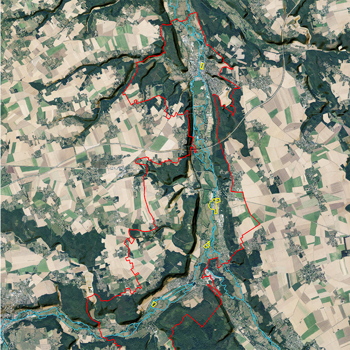
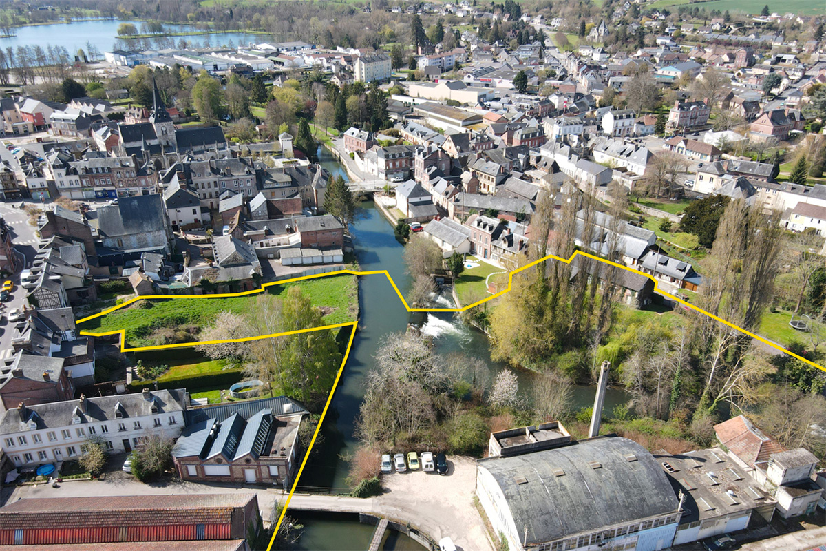
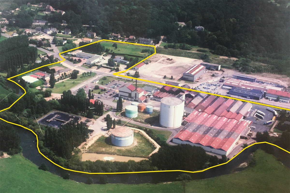
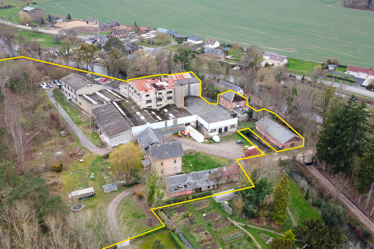
Reflection site 56 km2 - Project site Brionne : 2,7 ha; Nassandres-sur-Risle : 17ha; Serquigny : 3,7 ha; Fontaine l’Abbé : 2,6 ha
Site proposed by Intercommunality Bernay-Terres de Normandie, City of Brionne, Nassandres-sur-Risle, Serquigny, Fontaine l’Abbé
Actors involved Council of Architecture, Urbanism and Environment of Eure (CAUE27), Departmental Direction of Territories and Sea of Eure (DDTM27), Public Land Establishment of Normandie (EPFN), private owners of the sites, with the support of the National Agency of Territorial Cohesion.
Owner(s) of the site Cities and private owners
Commission after competition Study and project missions on one or more mutable sites. Operational follow-up may be initiated with partners.
More Information
Inhabited milieu's challenges
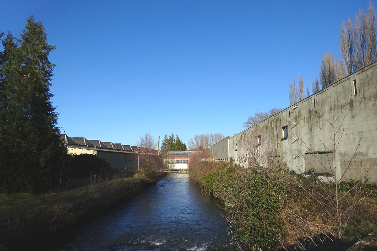
The Charentonne and Risle valleys (whose mouth is located in the Seine estuary) structure the territory of the Bernay-Terres de Normandie intercommunality. Their narrow alluvial plains, mainly occupied by floodable meadows and framed by steep, wooded hillsides, have also been the site of an urbanization focused on industrial production that exploited the energy of the waterways. The urban centers that punctuate these valleys are now experiencing contradictory and unsustainable dynamics:
- An industrial decline, leaving a legacy of unoccupied or underutilized wastelands, to be reintegrated into the territory.
- A residential decline, resulting in the peri-urbanization of the towns, which keeps the inhabitants away from employment and services.
The more general context of the climate transition and the evolution of European regulations on limiting the artificialization of land, or even its renaturation, requires a rethinking of land development in terms of sobriety and resi- lience.Thus, reinvesting wastelands is an opportunity to give back living spaces to the inhabitants, while contributing to the development and attractiveness of the territory.At the same time, and in rural areas in particular, this constitutes a major challenge.
The sites proposed for the competition have their own characteristics, but all of them border or are crossed by rivers.The Risle and Charentonne rivers, which structure the identity of the territory and are real living resources, link the town centers and the wastelands, giving the landscape and the environment a central place in the urban fabric. The projects submitted by the candidates will therefore contribute to revealing the important potential of attractiveness and development of these valleys by rehabilitating areas abandoned by production and by enhancing the living interfaces with the natural landscapes.
Questions to the competitors
The actors of this multi-site wish to draw up a coherent global strategy based on the green and blue framework of the valleys to imagine new ways of living in this territory. How can we let the rivers regain their position in the urban ecosystem in order to relearn how to live with water, its qualities and its risks? How can we make inhabitants rediscover the beauty and pleasures of water (hidden or privatized for a long time), how can we use it to balance the impacts of climate change, support the desire for nature and promote well-being in the city? How can we conserve the specific biodiversity that has developed in spaces abandoned by man and take advantage of it to renew the city?
It is also necessary to change the way we look at vacant spaces and to include their revitalization in the long history of the territory’s transformation, where the alternation of «productive» phases and times of « break « allows for collective reflection and experimentation of new uses and spatial forms. How can we reimagine the town centers of the valley floor based on these opportunities? What alternatives to suburbanization can we imagine for this terri- tory and with what qualities of living? How can we best develop the soil resource and preserve the ecosystemic and cultural services provided to the city, in order to make it more resilient to climate change and to the socio-economic upheavals that impact the territories?
Within a «circular» approach to land use development, it is also necessary to take into account the specificities of existing facilities.The sites proposed to the competition differ in terms of their size and period of building, the activities they host and the spatial qualities that result from them, their state of conservation, etc. How can we take advantage of what is already there to imagine articulations between the productive city and the living city? How can we take care of the built space, reinterpreting it to preserve the individual and collective memories that have been stratified in these places?
Questions on the site
Hello, Can you provide the source file for the "reflection site" map in vector format (dwg or other vector drawing)? The file in question is as follows: FR-BERNAY_TERRES_NORMANCIE-SS-M1 Thank you & have a nice day,
See New docs after launch in the complete site folder, new documents have been uploaded.
Could you please forward the biodiversity file mentioned during the site visit?
There is no exhaustive inventory of flora and fauna, but some elements
elements (produced by landscape design students as part of the
Vallées habitées" project) can be found in the file
FR-BERNAY_TERRES_NORMANDIE-PS1-A01.pdf added to the complete site folder.
Could you please send us plans and sections of the existing industrial wasteland sites?
Request in progress
Hello, how can I get back the documents mentioned during the site visit (precise inventory of natural species, etc.)? Thank you in advance. Best regards
See New docs after launch in the complete site folder, new docs have been uploaded.
Hello, Where can I find the answers to my questions? The site page doesn't seem to show the FAQ results...
See New docs after Launch in the complete site folder, new documents have been uploaded.
Is site n°4: FONTAINE-L'ABBÉ private or public? Are there any parts of site 4 to be demolished?
This is a privately-owned site that will be bought this year by the SCIC-SAS LES NOUVELLES COORDONNÉES (a cooperative society of collective interest).
The owner prefers to avoid demolition, since most of the buildings are in good condition (apart from the roofs, which will soon be redone). However, on the recommendation of the structural engineer, it is possible to remove all or part of a storey from the central building (known as "the wasteland") or to remove floor space.
Are there any documents/studies on the state of the rivers (Risle, Charentonne)? Pollution/fauna/flora/PPRI/PPRN + frequency of overflow/risk of flooding per project.
With regard to rivers, some data is available in the Schéma d'Aménagement et de Gestion des Eaux de la Risle et de la Charentonne (several documents can be downloaded here: https://www.gesteau.fr/sage/risle-et-charentonne )
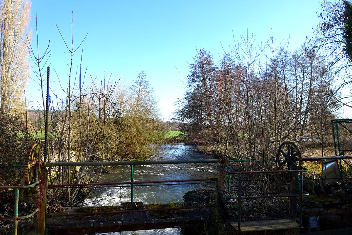
Is it possible to send us a territorial map or IGN data listing the mills in the valley?
The mills and hydraulic structures are listed in the Risle and Charentonne Water Development and Management Plan (https://www.gesteau.fr/sage/risle-et-charentonne)
Is it possible to send us the nature of the soil for each project?
Data not available
Which mill turbines are still in working order and/or can be reused?
The mills and hydraulic structures are listed in the Schéma d'Aménagement et de Gestion des Eaux de la Risle et de la Charentonne (https://www.gesteau.fr/sage/risle-et-charentonne). No mills or turbines are currently active on the 4 Europan project sites. On the Courcelles wasteland (Fontaine- l'Abbé), an active turbining right means that a hydroelectric micro-power station could be built.
Are there any Natura 2000 zones around the sites?
Two Natura 2000 sites (Risle-Guiel-Charentonne and Cavités de Beaumont le Roger), as well as several sensitive natural areas (ENS) and natural areas of ecological, faunistic and floristic interest (ZNIEFF). As for the Courcelles site (Fontaine- l'Abbé), plot 0097 is classified as "N" in the PLU* and is in the Natura 2000 zone, home to a protected dragonfly, the Agrion de Mercure.
*cf. the PLU at: https://www.geoportail-urbanisme.gouv.fr/map/#tile=1&lon=0.6949955700752618&lat=49.100001959524434&zoom=16.606666666666662&mlon=0.691575&mlat=49.090844
This site is connected to the following theme
IMAGINE A SECOND LIFE! A Second Life! is a metamorphosis of a situation. The challenge is to regenerate and to support spaces in need of transformation from a new perspective towards the pre-existences and the hidden treasures that are already there. A new revalorization of all kind of resources – natural, heritage, energy, flows, economy, social… It means to reconsider uses and new proximities linking ecological and social dynamics. How to be attentive and welcoming to differences and vulnerabilities nourished by inhabited milieus facing climate change?
Transforming neighbourhoods and buildings towards an inclusive milieu
Questions on the site
You have to be connected –and therefore registered– to be able to ask a question.
Fr. 16 May 2025
Deadline for submitting questions
Fr. 30 May 2025
Deadline for answers
Before submitting a question, make sure it does not already appear in the FAQ.
Please ask questions on sites in the Sites section.
Please ask questions on rules in the Rules section.
If your question does not receive any answer in 10 days, check the FAQ to make sure the answer does not appear under another label or email the secretariat concerned by the question (national secretariat for the sites, European secretariat for the rules).